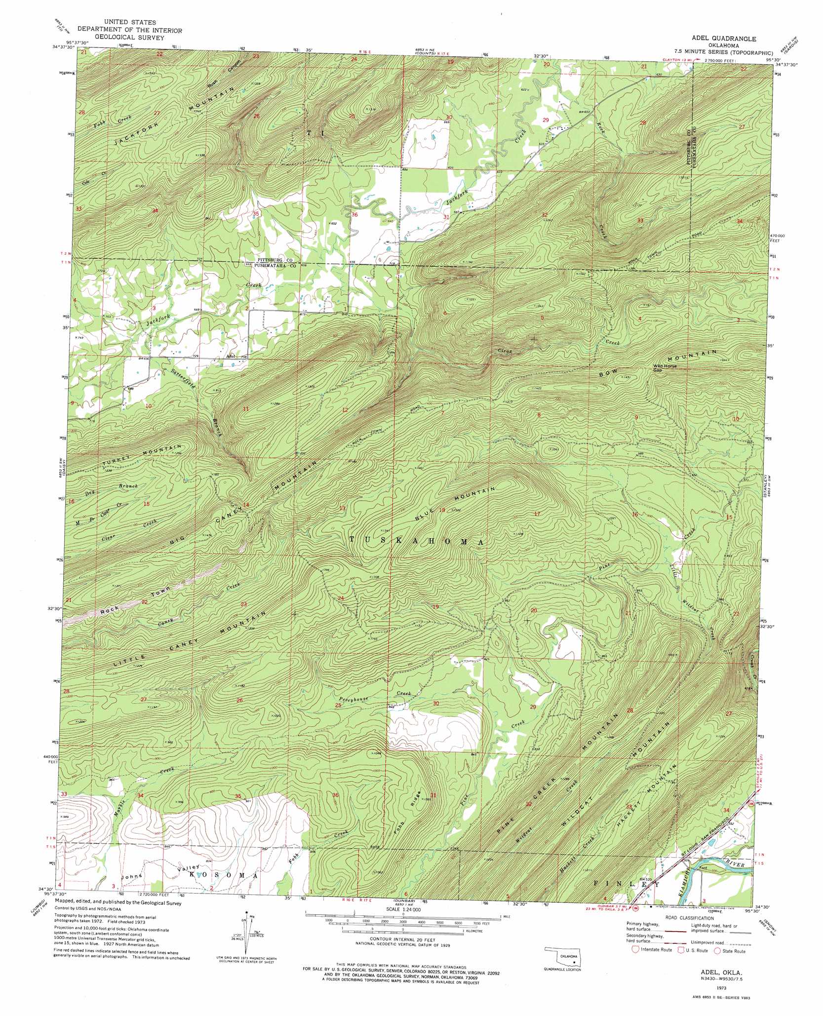
Adel Topo Map Oklahoma
To zoom in, hover over the map of Adel
USGS Topo Quad 34095e5 - 1:24,000 scale
| Topo Map Name: | Adel |
| USGS Topo Quad ID: | 34095e5 |
| Print Size: | ca. 21 1/4" wide x 27" high |
| Southeast Coordinates: | 34.5° N latitude / 95.5° W longitude |
| Map Center Coordinates: | 34.5625° N latitude / 95.5625° W longitude |
| U.S. State: | OK |
| Filename: | o34095e5.jpg |
| Download Map JPG Image: | Adel topo map 1:24,000 scale |
| Map Type: | Topographic |
| Topo Series: | 7.5´ |
| Map Scale: | 1:24,000 |
| Source of Map Images: | United States Geological Survey (USGS) |
| Alternate Map Versions: |
Adel OK 1973, updated 1975 Download PDF Buy paper map Adel OK 2010 Download PDF Buy paper map Adel OK 2012 Download PDF Buy paper map Adel OK 2016 Download PDF Buy paper map |
1:24,000 Topo Quads surrounding Adel
Savanna |
Hartshorne Sw |
Hartshorne |
Higgins |
Damon |
Pittsburg |
Ti |
Counts |
Sardis |
Yanush |
Redden |
Daisy |
Adel |
Stanley |
Clayton |
Lane Ne |
Jumbo |
Dunbar |
Snow |
Wildhorse Mountain |
Farris |
Moyers |
Kosoma |
Finley |
Cloudy |
> Back to 34095e1 at 1:100,000 scale
> Back to 34094a1 at 1:250,000 scale
> Back to U.S. Topo Maps home
Adel topo map: Gazetteer
Adel: Gaps
Wild Horse Gap elevation 411m 1348′Adel: Populated Places
Adel elevation 217m 711′Adel: Ridges
Fobb Ridge elevation 332m 1089′Rock Town elevation 346m 1135′
Adel: Streams
Clear Creek elevation 197m 646′Peveyhouse Creek elevation 239m 784′
Rock Creek elevation 189m 620′
Satterfield Branch elevation 207m 679′
Wildcat Creek elevation 271m 889′
Adel: Summits
Big Caney Mountain elevation 447m 1466′Blue Mountain elevation 458m 1502′
Bow Mountain elevation 470m 1541′
Hackett Mountain elevation 374m 1227′
Little Caney Mountain elevation 405m 1328′
Pine Creek Mountain elevation 445m 1459′
Turkey Mountain elevation 393m 1289′
Wildcat Mountain elevation 452m 1482′
Adel digital topo map on disk
Buy this Adel topo map showing relief, roads, GPS coordinates and other geographical features, as a high-resolution digital map file on DVD: