Fox Ne Topo Map Oklahoma
To zoom in, hover over the map of Fox Ne
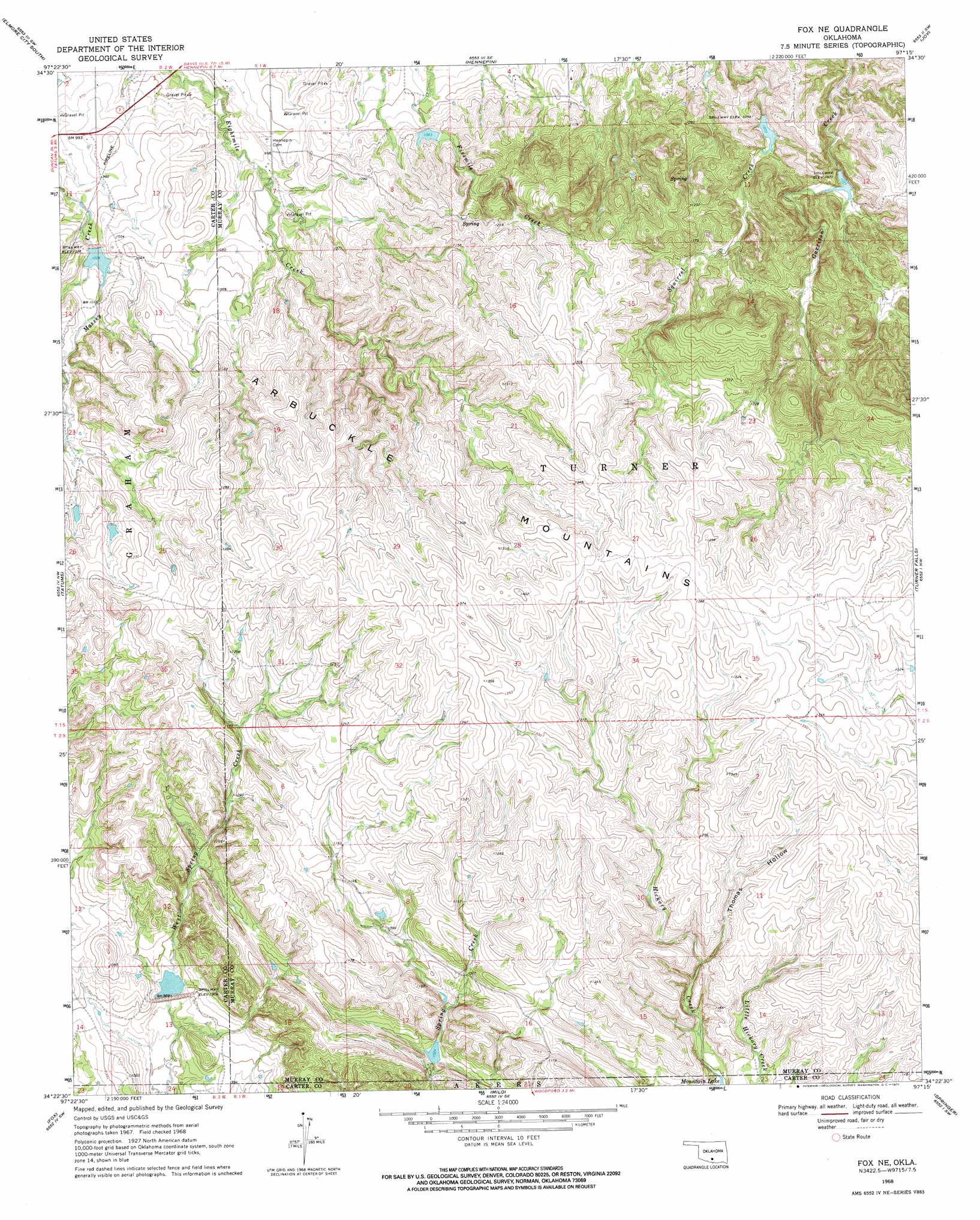
USGS Topo Quad 34097d3 - 1:24,000 scale
| Topo Map Name: | Fox Ne |
| USGS Topo Quad ID: | 34097d3 |
| Print Size: | ca. 21 1/4" wide x 27" high |
| Southeast Coordinates: | 34.375° N latitude / 97.25° W longitude |
| Map Center Coordinates: | 34.4375° N latitude / 97.3125° W longitude |
| U.S. State: | OK |
| Filename: | o34097d3.jpg |
| Download Map JPG Image: | Fox Ne topo map 1:24,000 scale |
| Map Type: | Topographic |
| Topo Series: | 7.5´ |
| Map Scale: | 1:24,000 |
| Source of Map Images: | United States Geological Survey (USGS) |
| Alternate Map Versions: |
Fox NE OK 1968, updated 1971 Download PDF Buy paper map Fox NE OK 2009 Download PDF Buy paper map Fox NE OK 2012 Download PDF Buy paper map Fox NE OK 2016 Download PDF Buy paper map |
1:24,000 Topo Quads surrounding Fox Ne
Purdy |
Elmore City North |
Elmore City Ne |
Pauls Valley |
Pauls Valley Ne |
Pernell |
Elmore City South |
Hennepin |
Joy |
Davis |
Ratliff City |
Tatums |
Fox Ne |
Turner Falls |
Dougherty |
Cottonwood Creek |
Fox |
Milo |
Springer |
Gene Autry |
Ringling |
Healdton |
Lone Grove |
Ardmore West |
Ardmore East |
> Back to 34097a1 at 1:100,000 scale
> Back to 34096a1 at 1:250,000 scale
> Back to U.S. Topo Maps home
Fox Ne topo map: Gazetteer
Fox Ne: Dams
Banks Humble Lake Number 1 Dam elevation 318m 1043′Caddo Creek Site 7 Dam elevation 308m 1010′
Wildhorse Creek Site 125 Dam elevation 305m 1000′
Wildhorse Creek Site 4 Dam elevation 312m 1023′
Wildhorse Creek Site 5 Dam elevation 331m 1085′
Wildhorse Creek Site 7 Dam elevation 312m 1023′
Wildhorse Creek Site 79 Dam elevation 298m 977′
Wildhorse Creek Site 9 Dam elevation 309m 1013′
Zelder Humble Lake Number 2 Dam elevation 312m 1023′
Fox Ne: Reservoirs
Banks Humble Lake Number 1 elevation 318m 1043′Caddo Creek Site 7 Reservoir elevation 308m 1010′
Wildhorse Creek Site 125 Reservoir elevation 305m 1000′
Wildhorse Creek Site 4 Reservoir elevation 312m 1023′
Wildhorse Creek Site 5 Reservoir elevation 331m 1085′
Wildhorse Creek Site 7 Reservoir elevation 312m 1023′
Wildhorse Creek Site 79 Reservoir elevation 298m 977′
Wildhorse Creek Site 9 Reservoir elevation 309m 1013′
Zelder Humble Lake Number 2 elevation 312m 1023′
Fox Ne: Streams
Thomas Creek elevation 345m 1131′Fox Ne: Valleys
Thomas Hollow elevation 339m 1112′Fox Ne digital topo map on disk
Buy this Fox Ne topo map showing relief, roads, GPS coordinates and other geographical features, as a high-resolution digital map file on DVD: