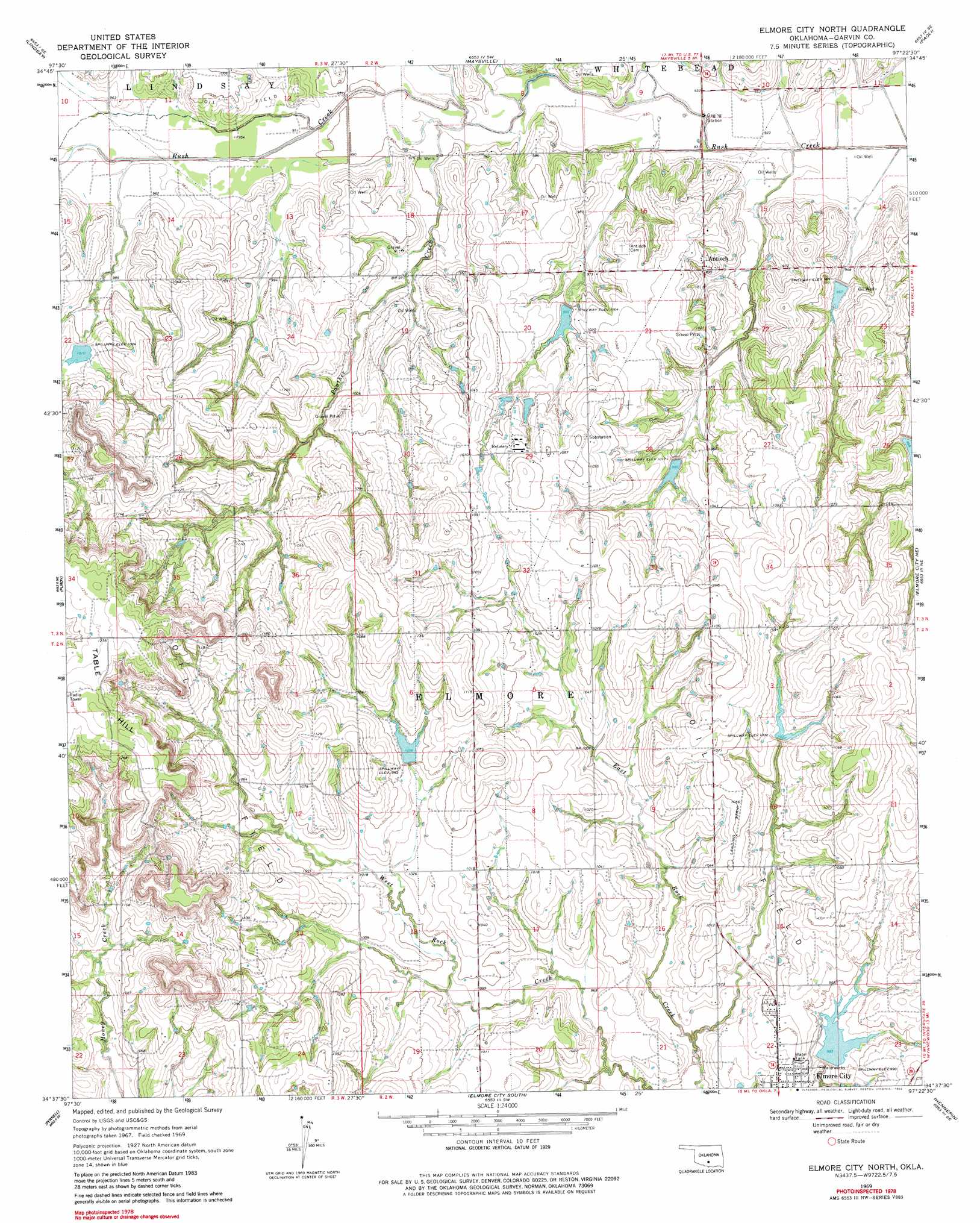
Elmore City North Topo Map Oklahoma
To zoom in, hover over the map of Elmore City North
USGS Topo Quad 34097f4 - 1:24,000 scale
| Topo Map Name: | Elmore City North |
| USGS Topo Quad ID: | 34097f4 |
| Print Size: | ca. 21 1/4" wide x 27" high |
| Southeast Coordinates: | 34.625° N latitude / 97.375° W longitude |
| Map Center Coordinates: | 34.6875° N latitude / 97.4375° W longitude |
| U.S. State: | OK |
| Filename: | o34097f4.jpg |
| Download Map JPG Image: | Elmore City North topo map 1:24,000 scale |
| Map Type: | Topographic |
| Topo Series: | 7.5´ |
| Map Scale: | 1:24,000 |
| Source of Map Images: | United States Geological Survey (USGS) |
| Alternate Map Versions: |
Elmore City North OK 1969, updated 1971 Download PDF Buy paper map Elmore City North OK 1969, updated 1982 Download PDF Buy paper map Elmore City North OK 2009 Download PDF Buy paper map Elmore City North OK 2013 Download PDF Buy paper map Elmore City North OK 2016 Download PDF Buy paper map |
1:24,000 Topo Quads surrounding Elmore City North
Bradley |
Criner |
Stealy |
Wayne |
Rosedale |
Lindsay Sw |
Lindsay |
Maysville |
Paoli |
Byars Sw |
Cox City |
Purdy |
Elmore City North |
Elmore City Ne |
Pauls Valley |
Lake Fuqua |
Pernell |
Elmore City South |
Hennepin |
Joy |
Velma |
Ratliff City |
Tatums |
Fox Ne |
Turner Falls |
> Back to 34097e1 at 1:100,000 scale
> Back to 34096a1 at 1:250,000 scale
> Back to U.S. Topo Maps home
Elmore City North topo map: Gazetteer
Elmore City North: Airports
McKey Airport elevation 321m 1053′Elmore City North: Dams
Hammers Gss Number 1 Dam elevation 318m 1043′Hill Gss Number 1 Dam elevation 310m 1017′
Oknoname 04908 Dam elevation 316m 1036′
Oknoname 04909 Dam elevation 317m 1040′
Oknoname 04910 Dam elevation 333m 1092′
Richardson Gss Number 1 Dam elevation 299m 980′
Rush Creek Site 106 Dam elevation 308m 1010′
Rush Creek Site 26 Dam elevation 327m 1072′
Rush Creek Site 32 Dam elevation 311m 1020′
Rush Creek Site 34 Dam elevation 298m 977′
Rush Creek Site 35 Dam elevation 306m 1003′
Rush Creek Site 36 Dam elevation 301m 987′
Rush Creek Site 39a Dam elevation 288m 944′
Rush Creek Site 47 Dam elevation 364m 1194′
Speaks Gss Number 1 Dam elevation 324m 1062′
Terry Gss Number 1 Dam elevation 317m 1040′
Wildhorse Creek Site 100 Dam elevation 317m 1040′
Wildhorse Creek Site 102 Dam elevation 321m 1053′
Wildhorse Creek Site 106 Dam elevation 305m 1000′
Wildhorse Creek Site 107 Dam elevation 300m 984′
Elmore City North: Populated Places
Antioch elevation 305m 1000′Elmore City North: Reservoirs
Hammers Gss Number 1 Reservoir elevation 318m 1043′Hill Gss Number 1 Reservoir elevation 310m 1017′
Oknoname 04708 Reservoir elevation 316m 1036′
Oknoname 04909 Reservoir elevation 317m 1040′
Oknoname 04910 Reservoir elevation 333m 1092′
Richardson Gss Number 1 Reservoir elevation 299m 980′
Rush Creek Site 106 Reservoir elevation 308m 1010′
Rush Creek Site 26 Reservoir elevation 327m 1072′
Rush Creek Site 32 Reservoir elevation 311m 1020′
Rush Creek Site 34 Reservoir elevation 298m 977′
Rush Creek Site 35 Reservoir elevation 306m 1003′
Rush Creek Site 36 Reservoir elevation 301m 987′
Rush Creek Site 39a Reservoir elevation 288m 944′
Rush Creek Site 47 Reservoir elevation 364m 1194′
Speaks Gss Number 1 Reservoir elevation 324m 1062′
Terry Gss Number 1 Reservoir elevation 317m 1040′
Wildhorse Creek Site 100 Reservoir elevation 317m 1040′
Wildhorse Creek Site 102 Reservoir elevation 321m 1053′
Wildhorse Creek Site 106 Reservoir elevation 305m 1000′
Wildhorse Creek Site 107 Reservoir elevation 300m 984′
Elmore City North: Streams
Panther Creek elevation 287m 941′Elmore City North: Summits
Table Hill elevation 394m 1292′Elmore City North digital topo map on disk
Buy this Elmore City North topo map showing relief, roads, GPS coordinates and other geographical features, as a high-resolution digital map file on DVD: