Paoli Topo Map Oklahoma
To zoom in, hover over the map of Paoli
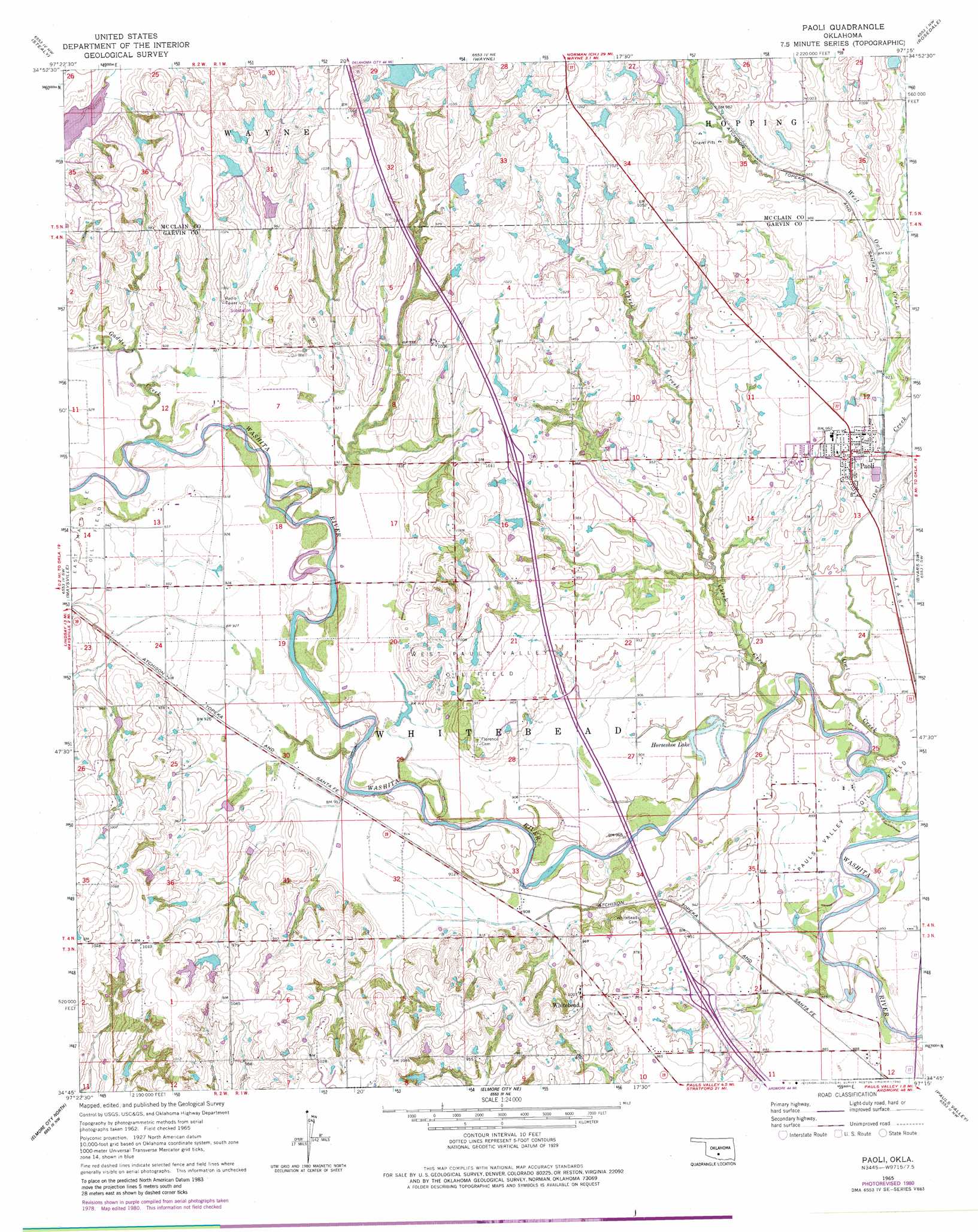
USGS Topo Quad 34097g3 - 1:24,000 scale
| Topo Map Name: | Paoli |
| USGS Topo Quad ID: | 34097g3 |
| Print Size: | ca. 21 1/4" wide x 27" high |
| Southeast Coordinates: | 34.75° N latitude / 97.25° W longitude |
| Map Center Coordinates: | 34.8125° N latitude / 97.3125° W longitude |
| U.S. State: | OK |
| Filename: | o34097g3.jpg |
| Download Map JPG Image: | Paoli topo map 1:24,000 scale |
| Map Type: | Topographic |
| Topo Series: | 7.5´ |
| Map Scale: | 1:24,000 |
| Source of Map Images: | United States Geological Survey (USGS) |
| Alternate Map Versions: |
Paoli OK 1965, updated 1966 Download PDF Buy paper map Paoli OK 1965, updated 1980 Download PDF Buy paper map Paoli OK 2010 Download PDF Buy paper map Paoli OK 2012 Download PDF Buy paper map Paoli OK 2016 Download PDF Buy paper map |
1:24,000 Topo Quads surrounding Paoli
Cole |
Washington |
Purcell |
Eason |
Tribbey |
Criner |
Stealy |
Wayne |
Rosedale |
Wanette |
Lindsay |
Maysville |
Paoli |
Byars Sw |
Byars |
Purdy |
Elmore City North |
Elmore City Ne |
Pauls Valley |
Pauls Valley Ne |
Pernell |
Elmore City South |
Hennepin |
Joy |
Davis |
> Back to 34097e1 at 1:100,000 scale
> Back to 34096a1 at 1:250,000 scale
> Back to U.S. Topo Maps home
Paoli topo map: Gazetteer
Paoli: Dams
Finn Creek Site 20 Dam elevation 299m 980′Maysville Laterals Site L3 Dam elevation 295m 967′
Maysville Laterals Site L4 Dam elevation 287m 941′
Maysville Laterals Site L5 Dam elevation 286m 938′
Maysville Laterals Site L6 Dam elevation 289m 948′
Maysville Laterals Site L7 Dam elevation 287m 941′
Oknoname 04901 Dam elevation 299m 980′
Oknoname 04902 Dam elevation 289m 948′
Oknoname 04918 Dam elevation 305m 1000′
Oknoname 087045 Dam elevation 306m 1003′
Owl Creek Site 5 Dam elevation 303m 994′
Owl Creek Site 6 Dam elevation 299m 980′
Owl Creek Site 7 Dam elevation 293m 961′
Wayne Creek Site 1 Dam elevation 300m 984′
Wayne Creek Site 2 Dam elevation 293m 961′
Paoli: Lakes
Horseshoe Lake elevation 271m 889′Paoli: Oilfields
Pauls Valley Oil Field elevation 269m 882′West Pauls Valley Oil Field elevation 299m 980′
Paoli: Populated Places
Paoli elevation 290m 951′White Bead elevation 302m 990′
White Bead Hill (historical) elevation 291m 954′
Whitebead elevation 308m 1010′
Paoli: Reservoirs
Finn Creek Site 20 Reservoir elevation 299m 980′Maysville Laterals Site L3 Reservoir elevation 295m 967′
Maysville Laterals Site L4 Reservoir elevation 287m 941′
Maysville Laterals Site L5 Reservoir elevation 286m 938′
Maysville Laterals Site L6 Reservoir elevation 289m 948′
Maysville Laterals Site L7 Reservoir elevation 287m 941′
Oknoname 04901 Reservoir elevation 299m 980′
Oknoname 04902 Reservoir elevation 289m 948′
Oknoname 04918 Reservoir elevation 305m 1000′
Oknoname 087045 Reservoir elevation 306m 1003′
Owl Creek Site 5 Reservoir elevation 303m 994′
Owl Creek Site 6 Reservoir elevation 299m 980′
Owl Creek Site 7 Reservoir elevation 293m 961′
Wayne Creek Site 1 Reservoir elevation 300m 984′
Wayne Creek Site 2 Reservoir elevation 293m 961′
Paoli: Streams
Cheek Creek elevation 317m 1040′Gaddis Creek elevation 276m 905′
Owl Creek elevation 268m 879′
West Owl Creek elevation 276m 905′
Paoli digital topo map on disk
Buy this Paoli topo map showing relief, roads, GPS coordinates and other geographical features, as a high-resolution digital map file on DVD: