Lindsay Sw Topo Map Oklahoma
To zoom in, hover over the map of Lindsay Sw
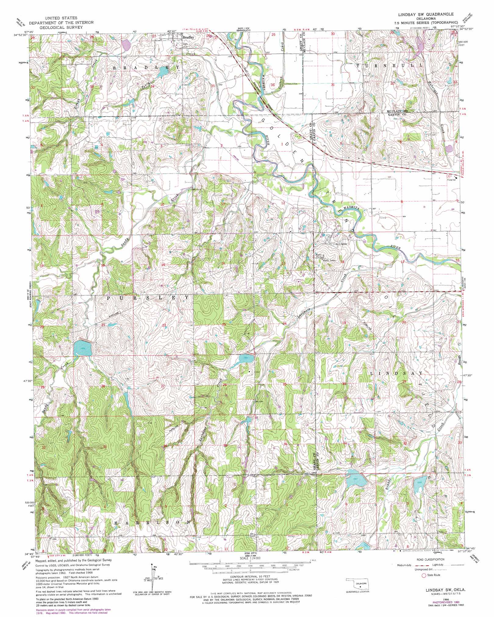
USGS Topo Quad 34097g6 - 1:24,000 scale
| Topo Map Name: | Lindsay Sw |
| USGS Topo Quad ID: | 34097g6 |
| Print Size: | ca. 21 1/4" wide x 27" high |
| Southeast Coordinates: | 34.75° N latitude / 97.625° W longitude |
| Map Center Coordinates: | 34.8125° N latitude / 97.6875° W longitude |
| U.S. State: | OK |
| Filename: | o34097g6.jpg |
| Download Map JPG Image: | Lindsay Sw topo map 1:24,000 scale |
| Map Type: | Topographic |
| Topo Series: | 7.5´ |
| Map Scale: | 1:24,000 |
| Source of Map Images: | United States Geological Survey (USGS) |
| Alternate Map Versions: |
Lindsay SW OK 1966, updated 1967 Download PDF Buy paper map Lindsay SW OK 1966, updated 1980 Download PDF Buy paper map Lindsay SW OK 1966, updated 1984 Download PDF Buy paper map Lindsay SW OK 2009 Download PDF Buy paper map Lindsay SW OK 2012 Download PDF Buy paper map Lindsay SW OK 2016 Download PDF Buy paper map |
1:24,000 Topo Quads surrounding Lindsay Sw
Chickasha |
Tabler |
Dibble |
Cole |
Washington |
East Ninnekah |
Alex |
Bradley |
Criner |
Stealy |
Rush Springs |
East Roaring Creek |
Lindsay Sw |
Lindsay |
Maysville |
Marlow |
Bray |
Cox City |
Purdy |
Elmore City North |
Duncan North |
Hope |
Lake Fuqua |
Pernell |
Elmore City South |
> Back to 34097e1 at 1:100,000 scale
> Back to 34096a1 at 1:250,000 scale
> Back to U.S. Topo Maps home
Lindsay Sw topo map: Gazetteer
Lindsay Sw: Airports
Mash Heliport elevation 321m 1053′Lindsay Sw: Dams
Bear Hybarger Site 2 Dam elevation 313m 1026′Bear Hybarger Site 3 Dam elevation 302m 990′
Bear Hybarger Site 4 Dam elevation 306m 1003′
Roaring Creek Site B-1 Dam elevation 315m 1033′
Round Creek Site 1 Dam elevation 313m 1026′
Round Creek Site 2 Dam elevation 331m 1085′
Round Creek Site 3 Dam elevation 338m 1108′
Round Creek Site 4 Dam elevation 333m 1092′
Round Creek Site 5 Dam elevation 321m 1053′
Round Creek Site 6 Dam elevation 329m 1079′
Round Creek Site 9 Dam elevation 319m 1046′
Lindsay Sw: Reservoirs
Bear Hybarger Site 2 Reservoir elevation 313m 1026′Bear Hybarger Site 3 Reservoir elevation 302m 990′
Bear Hybarger Site 4 Reservoir elevation 306m 1003′
Roaring Creek Site B-1 Reservoir elevation 315m 1033′
Round Creek Site 1 Reservoir elevation 313m 1026′
Round Creek Site 2 Reservoir elevation 331m 1085′
Round Creek Site 3 Reservoir elevation 338m 1108′
Round Creek Site 4 Reservoir elevation 333m 1092′
Round Creek Site 5 Reservoir elevation 321m 1053′
Round Creek Site 6 Reservoir elevation 329m 1079′
Round Creek Site 9 Reservoir elevation 319m 1046′
Lindsay Sw: Streams
Colbert Creek elevation 298m 977′Larimore Creek elevation 296m 971′
Sandy Creek elevation 298m 977′
Slough Creek elevation 298m 977′
Terry Creek elevation 299m 980′
Lindsay Sw digital topo map on disk
Buy this Lindsay Sw topo map showing relief, roads, GPS coordinates and other geographical features, as a high-resolution digital map file on DVD: