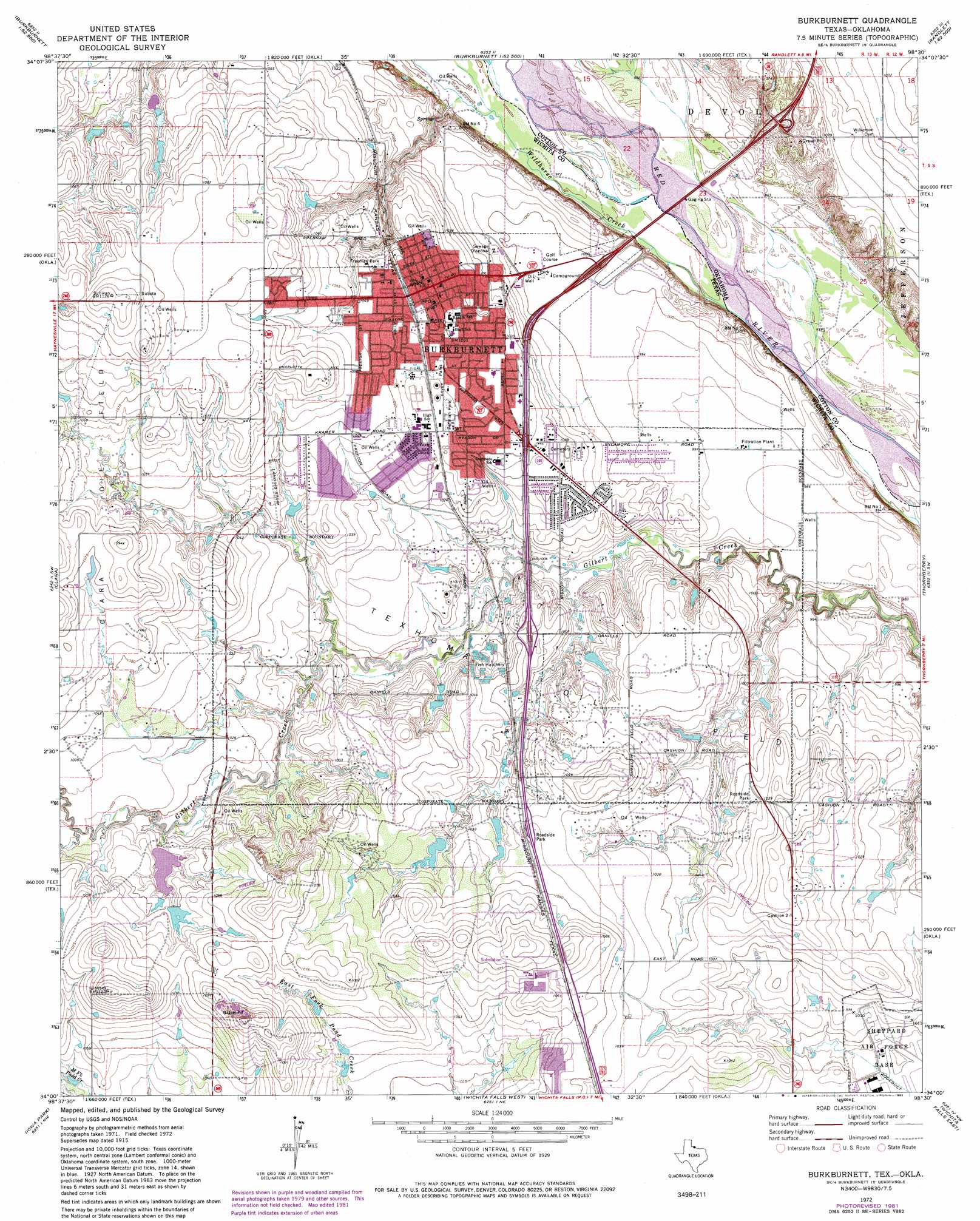
Burkburnett Topo Map Texas
To zoom in, hover over the map of Burkburnett
USGS Topo Quad 34098a5 - 1:24,000 scale
| Topo Map Name: | Burkburnett |
| USGS Topo Quad ID: | 34098a5 |
| Print Size: | ca. 21 1/4" wide x 27" high |
| Southeast Coordinates: | 34° N latitude / 98.5° W longitude |
| Map Center Coordinates: | 34.0625° N latitude / 98.5625° W longitude |
| U.S. States: | TX, OK |
| Filename: | o34098a5.jpg |
| Download Map JPG Image: | Burkburnett topo map 1:24,000 scale |
| Map Type: | Topographic |
| Topo Series: | 7.5´ |
| Map Scale: | 1:24,000 |
| Source of Map Images: | United States Geological Survey (USGS) |
| Alternate Map Versions: |
Burkburnett TX 1915, updated 1961 Download PDF Buy paper map Burkburnett TX 1972, updated 1975 Download PDF Buy paper map Burkburnett TX 1972, updated 1982 Download PDF Buy paper map Burkburnett TX 1972, updated 1983 Download PDF Buy paper map Burkburnett TX 2010 Download PDF Buy paper map Burkburnett TX 2012 Download PDF Buy paper map Burkburnett TX 2016 Download PDF Buy paper map |
1:24,000 Topo Quads surrounding Burkburnett
Hollister |
Chattanooga Sw |
Whites Lake |
Cookietown |
Walters |
Augar Creek |
Grandfield |
Devol |
Randlett |
Taylor |
Sunshine Hill |
Clara |
Burkburnett |
Thornberry |
Charlie |
Fowlkes |
Iowa Park |
Wichita Falls West |
Wichita Falls East |
Dean |
Mankins |
Holliday |
Lake Wichita |
Sloop Creek |
Jolly |
> Back to 34098a1 at 1:100,000 scale
> Back to 34098a1 at 1:250,000 scale
> Back to U.S. Topo Maps home
Burkburnett topo map: Gazetteer
Burkburnett: Dams
Barbour-Kitchell Lake Dam elevation 316m 1036′Crumpler Lake Dam elevation 314m 1030′
Preston Lake Dam elevation 315m 1033′
Burkburnett: Oilfields
Texhoma Oil Field elevation 313m 1026′Burkburnett: Parks
Bulldog Stadium elevation 320m 1049′Freeman Park elevation 319m 1046′
Permian Park elevation 316m 1036′
Burkburnett: Populated Places
Burkburnett elevation 323m 1059′Cashion Community elevation 303m 994′
Burkburnett: Reservoirs
Barbour-Kitchell Lake elevation 316m 1036′Crumpler Lake elevation 314m 1030′
Preston Lake elevation 315m 1033′
Burkburnett: Streams
Wildhorse Creek elevation 292m 958′Wildhorse Creek elevation 292m 958′
Burkburnett digital topo map on disk
Buy this Burkburnett topo map showing relief, roads, GPS coordinates and other geographical features, as a high-resolution digital map file on DVD: