Hollister Ne Topo Map Oklahoma
To zoom in, hover over the map of Hollister Ne
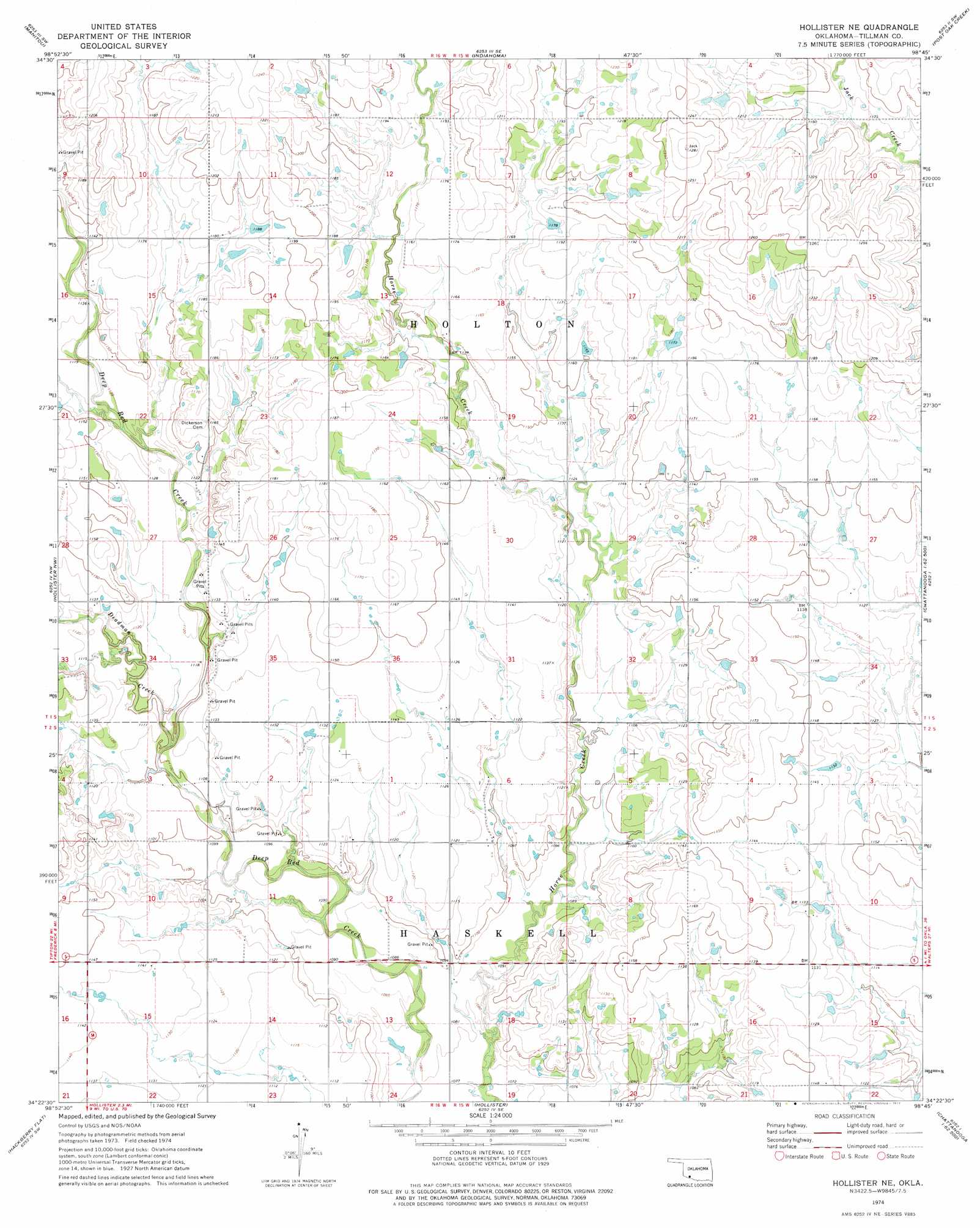
USGS Topo Quad 34098d7 - 1:24,000 scale
| Topo Map Name: | Hollister Ne |
| USGS Topo Quad ID: | 34098d7 |
| Print Size: | ca. 21 1/4" wide x 27" high |
| Southeast Coordinates: | 34.375° N latitude / 98.75° W longitude |
| Map Center Coordinates: | 34.4375° N latitude / 98.8125° W longitude |
| U.S. State: | OK |
| Filename: | o34098d7.jpg |
| Download Map JPG Image: | Hollister Ne topo map 1:24,000 scale |
| Map Type: | Topographic |
| Topo Series: | 7.5´ |
| Map Scale: | 1:24,000 |
| Source of Map Images: | United States Geological Survey (USGS) |
| Alternate Map Versions: |
Hollister NE OK 1974, updated 1977 Download PDF Buy paper map Hollister NE OK 2010 Download PDF Buy paper map Hollister NE OK 2012 Download PDF Buy paper map Hollister NE OK 2016 Download PDF Buy paper map |
1:24,000 Topo Quads surrounding Hollister Ne
Long Mountain |
Snyder |
Odetta |
Quanah Mountain |
Mount Scott |
Tipton Se |
Manitou |
Indiahoma |
Post Oak Creek |
Taupa |
Frederick |
Hollister Nw |
Hollister Ne |
Chattanooga |
Faxon |
Frederick Se |
Hackberry Flat |
Hollister |
Chattanooga Sw |
Whites Lake |
Davidson |
Cowboy Springs |
Augar Creek |
Grandfield |
Devol |
> Back to 34098a1 at 1:100,000 scale
> Back to 34098a1 at 1:250,000 scale
> Back to U.S. Topo Maps home
Hollister Ne topo map: Gazetteer
Hollister Ne: Dams
Oknoname 141012 Dam elevation 346m 1135′Oknoname 141013 Dam elevation 354m 1161′
Oknoname 141014 Dam elevation 360m 1181′
Oknoname 141016 Dam elevation 371m 1217′
Oknoname 141017 Dam elevation 358m 1174′
Oknoname 141018 Dam elevation 359m 1177′
Hollister Ne: Reservoirs
Oknoname 141012 Reservoir elevation 346m 1135′Oknoname 141013 Reservoir elevation 354m 1161′
Oknoname 141014 Reservoir elevation 360m 1181′
Oknoname 141016 Reservoir elevation 371m 1217′
Oknoname 141017 Reservoir elevation 358m 1174′
Oknoname 141018 Reservoir elevation 359m 1177′
Hollister Ne: Streams
Deadman Creek elevation 337m 1105′Hollister Ne digital topo map on disk
Buy this Hollister Ne topo map showing relief, roads, GPS coordinates and other geographical features, as a high-resolution digital map file on DVD: