Denton Topo Map Oklahoma
To zoom in, hover over the map of Denton
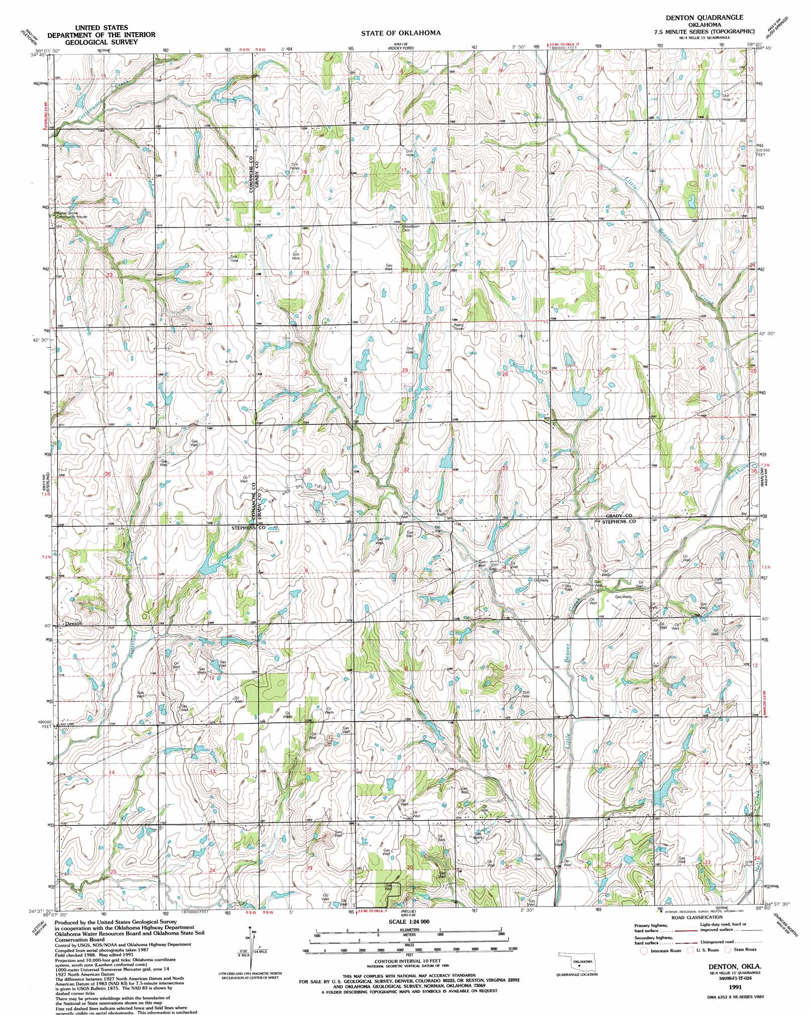
USGS Topo Quad 34098f1 - 1:24,000 scale
| Topo Map Name: | Denton |
| USGS Topo Quad ID: | 34098f1 |
| Print Size: | ca. 21 1/4" wide x 27" high |
| Southeast Coordinates: | 34.625° N latitude / 98° W longitude |
| Map Center Coordinates: | 34.6875° N latitude / 98.0625° W longitude |
| U.S. State: | OK |
| Filename: | o34098f1.jpg |
| Download Map JPG Image: | Denton topo map 1:24,000 scale |
| Map Type: | Topographic |
| Topo Series: | 7.5´ |
| Map Scale: | 1:24,000 |
| Source of Map Images: | United States Geological Survey (USGS) |
| Alternate Map Versions: |
Denton OK 1956, updated 1959 Download PDF Buy paper map Denton OK 1956, updated 1976 Download PDF Buy paper map Denton OK 1991, updated 1991 Download PDF Buy paper map Denton OK 2009 Download PDF Buy paper map Denton OK 2013 Download PDF Buy paper map Denton OK 2016 Download PDF Buy paper map |
1:24,000 Topo Quads surrounding Denton
Apache |
Cyril |
Laverty |
East Ninnekah |
Alex |
Elgin |
Fletcher |
Rocky Ford |
Rush Springs |
East Roaring Creek |
Arbuckle Hill |
Sterling |
Denton |
Marlow |
Bray |
Ninemile Creek |
Letitia |
Nellie |
Duncan North |
Hope |
Walters Ne |
Temple Nw |
Empire City |
Duncan South |
Harrisburg |
> Back to 34098e1 at 1:100,000 scale
> Back to 34098a1 at 1:250,000 scale
> Back to U.S. Topo Maps home
Denton topo map: Gazetteer
Denton: Dams
Oknoname 051048 Dam elevation 381m 1250′Oknoname 051058 Dam elevation 374m 1227′
Oknoname 051059 Dam elevation 381m 1250′
Oknoname 137002 Dam elevation 361m 1184′
Oknoname 137003 Dam elevation 371m 1217′
Oknoname 137004 Dam elevation 364m 1194′
Oknoname 137061 Dam elevation 361m 1184′
Oknoname 137062 Dam elevation 366m 1200′
Oknoname 137063 Dam elevation 366m 1200′
Oknoname 137064 Dam elevation 370m 1213′
Oknoname 137088 Dam elevation 367m 1204′
Richard Cox Dam elevation 382m 1253′
Denton: Populated Places
Denton elevation 371m 1217′Denton: Reservoirs
Oknoname 051048 Reservoir elevation 381m 1250′Oknoname 051058 Reservoir elevation 374m 1227′
Oknoname 051059 Reservoir elevation 381m 1250′
Oknoname 137002 Reservoir elevation 361m 1184′
Oknoname 137003 Reservoir elevation 371m 1217′
Oknoname 137004 Reservoir elevation 364m 1194′
Oknoname 137061 Reservoir elevation 361m 1184′
Oknoname 137062 Reservoir elevation 366m 1200′
Oknoname 137063 Reservoir elevation 366m 1200′
Oknoname 137064 Reservoir elevation 370m 1213′
Oknoname 137088 Reservoir elevation 367m 1204′
Richard Cox Reservoir elevation 382m 1253′
Denton: Streams
Buckhorn Creek elevation 356m 1167′Denton digital topo map on disk
Buy this Denton topo map showing relief, roads, GPS coordinates and other geographical features, as a high-resolution digital map file on DVD: