Fort Sill Topo Map Oklahoma
To zoom in, hover over the map of Fort Sill
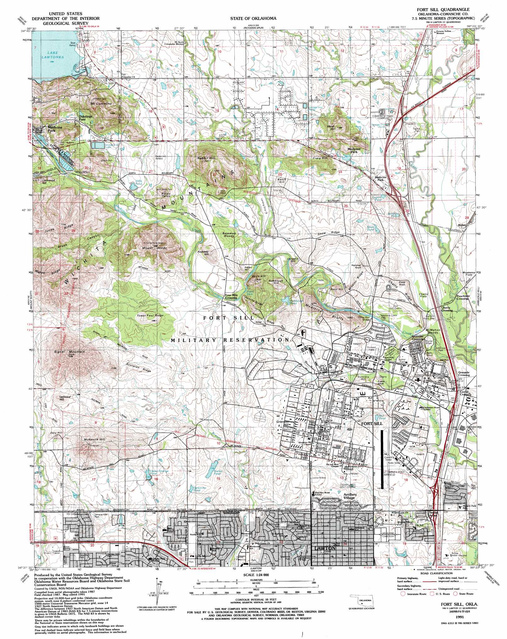
USGS Topo Quad 34098f4 - 1:24,000 scale
| Topo Map Name: | Fort Sill |
| USGS Topo Quad ID: | 34098f4 |
| Print Size: | ca. 21 1/4" wide x 27" high |
| Southeast Coordinates: | 34.625° N latitude / 98.375° W longitude |
| Map Center Coordinates: | 34.6875° N latitude / 98.4375° W longitude |
| U.S. State: | OK |
| Filename: | o34098f4.jpg |
| Download Map JPG Image: | Fort Sill topo map 1:24,000 scale |
| Map Type: | Topographic |
| Topo Series: | 7.5´ |
| Map Scale: | 1:24,000 |
| Source of Map Images: | United States Geological Survey (USGS) |
| Alternate Map Versions: |
Fort Sill OK 1949, updated 1953 Download PDF Buy paper map Fort Sill OK 1956, updated 1959 Download PDF Buy paper map Fort Sill OK 1956, updated 1971 Download PDF Buy paper map Fort Sill OK 1956, updated 1976 Download PDF Buy paper map Fort Sill OK 1991, updated 1991 Download PDF Buy paper map Fort Sill OK 2010 Download PDF Buy paper map Fort Sill OK 2012 Download PDF Buy paper map Fort Sill OK 2016 Download PDF Buy paper map |
1:24,000 Topo Quads surrounding Fort Sill
Bally Mountain |
Alden |
Boone |
Apache |
Cyril |
Saddle Mountain |
Meers |
Richards Spur |
Elgin |
Fletcher |
Quanah Mountain |
Mount Scott |
Fort Sill |
Arbuckle Hill |
Sterling |
Post Oak Creek |
Taupa |
Lawton |
Ninemile Creek |
Letitia |
Chattanooga |
Faxon |
Geronimo |
Walters Ne |
Temple Nw |
> Back to 34098e1 at 1:100,000 scale
> Back to 34098a1 at 1:250,000 scale
> Back to U.S. Topo Maps home
Fort Sill topo map: Gazetteer
Fort Sill: Airports
Henry Post Army Air Field elevation 360m 1181′Landing Strip Fifteen elevation 363m 1190′
Rabbit Hill Airfield elevation 391m 1282′
Fort Sill: Areas
Martha Songbird Wildlife Management Area elevation 344m 1128′Fort Sill: Bays
Heyls Hole elevation 360m 1181′Fort Sill: Bridges
Stevens Bridge elevation 336m 1102′White Wolf Bridge elevation 344m 1128′
Fort Sill: Cliffs
Medicine Bluffs elevation 406m 1332′Fort Sill: Flats
Bateman Woods elevation 370m 1213′Chatto Flats elevation 341m 1118′
McMahon Woods elevation 341m 1118′
Musketry Flats elevation 348m 1141′
Fort Sill: Lakes
Geronimo Pond elevation 347m 1138′Jump Pond elevation 355m 1164′
Legion Pond elevation 361m 1184′
Nineteen Seventy-six Pond elevation 381m 1250′
Owl Pond elevation 353m 1158′
Rocket Pond elevation 356m 1167′
Rumbough Pond elevation 358m 1174′
Snow Pond elevation 356m 1167′
Upper Strange Pond elevation 366m 1200′
Fort Sill: Parks
Ambrosia Park elevation 348m 1141′Butch Suttle Park elevation 356m 1167′
Butner Field elevation 345m 1131′
Charlie Ray Park elevation 345m 1131′
Estelle Jones Park elevation 362m 1187′
Fort Sill National Historic Site elevation 344m 1128′
Francis Curb Park elevation 346m 1135′
Francis Curt Park elevation 351m 1151′
Gray-Warr Park elevation 369m 1210′
Harold Park elevation 341m 1118′
Hunter Hills Park elevation 365m 1197′
Jack Laughter Park elevation 383m 1256′
James Arthur Manning State Fish Hatchery elevation 385m 1263′
Legion Park elevation 342m 1122′
M. Songbird Management Area elevation 344m 1128′
Medicine Creek Park elevation 345m 1131′
Panther Park elevation 345m 1131′
Prichard Field elevation 348m 1141′
Rucker Park elevation 342m 1122′
Stephens Park elevation 341m 1118′
Terrace Hills Park elevation 364m 1194′
Tiapiha Park elevation 348m 1141′
Fort Sill: Populated Places
Artillery Village elevation 364m 1194′Chatto Crossing elevation 341m 1118′
Corral Crossing elevation 341m 1118′
Duhringe Pass elevation 402m 1318′
Four Mile Crossing elevation 364m 1194′
Grenade Crossing elevation 342m 1122′
Peachtree Crossing elevation 339m 1112′
Ridley elevation 352m 1154′
Sneed Acres elevation 344m 1128′
Fort Sill: Ranges
Mount Cummins elevation 515m 1689′Fort Sill: Ridges
Apache Ridge elevation 393m 1289′Artillery Ridge elevation 383m 1256′
Chatto Ridge elevation 351m 1151′
Jones Ridge elevation 459m 1505′
March Ridge elevation 487m 1597′
Mission Ridge elevation 366m 1200′
Scorpion Ridge elevation 385m 1263′
Snow Ridge elevation 378m 1240′
Tower Four Ridge elevation 391m 1282′
Fort Sill: Streams
Beef Creek elevation 336m 1102′Deer Creek elevation 381m 1250′
Ketch Creek elevation 353m 1158′
Lime Creek elevation 346m 1135′
Medicine Creek elevation 336m 1102′
Rabbit Creek elevation 358m 1174′
Fort Sill: Summits
Andrews Hill elevation 403m 1322′Chrystie Hill elevation 368m 1207′
Corral Hill elevation 351m 1151′
Craig Hill elevation 411m 1348′
Daly Hill elevation 406m 1332′
Ennis Knob elevation 360m 1181′
Evans Knob elevation 351m 1151′
Grierson Hill elevation 376m 1233′
Gunnery Hill elevation 355m 1164′
Hand Hill elevation 380m 1246′
Heyls Hill elevation 403m 1322′
Hummel Knoll elevation 378m 1240′
Indian Hill elevation 387m 1269′
Ketch Hill elevation 385m 1263′
Ledward Hill elevation 413m 1354′
Lockwood Hill elevation 420m 1377′
McKenzie Hill elevation 449m 1473′
Mount Hinds elevation 476m 1561′
Mountain Cumming elevation 523m 1715′
Rabbit Hill elevation 498m 1633′
Rocky Twins elevation 428m 1404′
Rumbough Hill elevation 391m 1282′
Signal Mountain elevation 529m 1735′
Welsh Hill elevation 434m 1423′
Fort Sill: Valleys
Brush Canyon elevation 375m 1230′Fort Sill digital topo map on disk
Buy this Fort Sill topo map showing relief, roads, GPS coordinates and other geographical features, as a high-resolution digital map file on DVD: