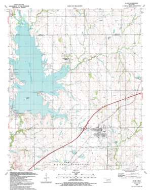
Elgin Topo Map Oklahoma
To zoom in, hover over the map of Elgin
USGS Topo Quad 34098g3 - 1:24,000 scale
| Topo Map Name: | Elgin |
| USGS Topo Quad ID: | 34098g3 |
| Print Size: | ca. 21 1/4" wide x 27" high |
| Southeast Coordinates: | 34.75° N latitude / 98.25° W longitude |
| Map Center Coordinates: | 34.8125° N latitude / 98.3125° W longitude |
| U.S. State: | OK |
| Filename: | o34098g3.jpg |
| Download Map JPG Image: | Elgin topo map 1:24,000 scale |
| Map Type: | Topographic |
| Topo Series: | 7.5´ |
| Map Scale: | 1:24,000 |
| Source of Map Images: | United States Geological Survey (USGS) |
| Alternate Map Versions: |
Elgin OK 1949, updated 1953 Download PDF Buy paper map Elgin OK 1956, updated 1959 Download PDF Buy paper map Elgin OK 1956, updated 1976 Download PDF Buy paper map Elgin OK 1956, updated 1983 Download PDF Buy paper map Elgin OK 1991, updated 1992 Download PDF Buy paper map Elgin OK 2010 Download PDF Buy paper map Elgin OK 2012 Download PDF Buy paper map Elgin OK 2016 Download PDF Buy paper map |
1:24,000 Topo Quads surrounding Elgin
> Back to 34098e1 at 1:100,000 scale
> Back to 34098a1 at 1:250,000 scale
> Back to U.S. Topo Maps home
Elgin topo map: Gazetteer
Elgin: Bays
Fulton Arm elevation 377m 1236′Goodin Arm elevation 377m 1236′
Hasenbach Arm elevation 377m 1236′
Mann Arm elevation 377m 1236′
Martin Arm elevation 377m 1236′
Schammahorn Slough elevation 377m 1236′
Elgin: Dams
Ellsworth Dam elevation 377m 1236′Oknoname 031001 Dam elevation 379m 1243′
Oknoname 031002 Dam elevation 389m 1276′
Oknoname 031007 Dam elevation 382m 1253′
Oknoname 031016 Dam elevation 377m 1236′
Elgin: Islands
Treasure Island elevation 378m 1240′Elgin: Lakes
Duck Pond elevation 384m 1259′Hunting Horse Pond elevation 379m 1243′
Love Pond elevation 386m 1266′
Northeast Corner Pond elevation 383m 1256′
Northeast Pond elevation 386m 1266′
Quannett Pond elevation 384m 1259′
Upper Frisco Pond elevation 389m 1276′
Elgin: Populated Places
Cove Acres elevation 379m 1243′Elgin elevation 394m 1292′
Lake Ellsworth Addition elevation 387m 1269′
Elgin: Reservoirs
Lake Ellsworth elevation 373m 1223′Menard Pond elevation 381m 1250′
O'Connell Pond elevation 384m 1259′
Oknoname 031001 Reservoir elevation 379m 1243′
Oknoname 031002 Reservoir elevation 389m 1276′
Oknoname 031007 Reservoir elevation 382m 1253′
Oknoname 031016 Reservoir elevation 377m 1236′
Rudd Pond elevation 375m 1230′
Elgin: Ridges
Frisco Ridge elevation 398m 1305′Elgin: Streams
Nunn Creek elevation 377m 1236′Rock Creek elevation 352m 1154′
Tony Creek elevation 378m 1240′
Elgin digital topo map on disk
Buy this Elgin topo map showing relief, roads, GPS coordinates and other geographical features, as a high-resolution digital map file on DVD:


