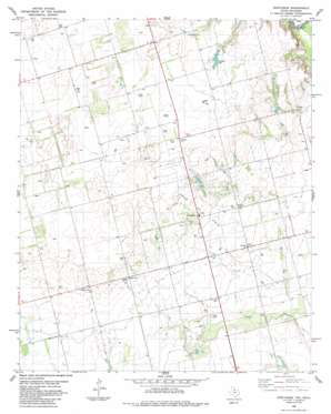
Northside Topo Map Texas
To zoom in, hover over the map of Northside
USGS Topo Quad 34099c3 - 1:24,000 scale
| Topo Map Name: | Northside |
| USGS Topo Quad ID: | 34099c3 |
| Print Size: | ca. 21 1/4" wide x 27" high |
| Southeast Coordinates: | 34.25° N latitude / 99.25° W longitude |
| Map Center Coordinates: | 34.3125° N latitude / 99.3125° W longitude |
| U.S. States: | TX, OK |
| Filename: | o34099c3.jpg |
| Download Map JPG Image: | Northside topo map 1:24,000 scale |
| Map Type: | Topographic |
| Topo Series: | 7.5´ |
| Map Scale: | 1:24,000 |
| Source of Map Images: | United States Geological Survey (USGS) |
| Alternate Map Versions: |
Northside TX 1985, updated 1985 Download PDF Buy paper map Northside TX 2010 Download PDF Buy paper map Northside TX 2012 Download PDF Buy paper map Northside TX 2016 Download PDF Buy paper map |
1:24,000 Topo Quads surrounding Northside
> Back to 34099a1 at 1:100,000 scale
> Back to 34098a1 at 1:250,000 scale
> Back to U.S. Topo Maps home
Northside topo map: Gazetteer
Northside: Dams
Hamilton Lake Dam elevation 399m 1309′Vernon Rod and Gun Club Lake Dam elevation 381m 1250′
Northside: Lakes
Hamilton Lake elevation 397m 1302′Northside: Oilfields
Fargo Oil Field elevation 407m 1335′Northside: Populated Places
Doans elevation 376m 1233′Fargo elevation 381m 1250′
Northside elevation 400m 1312′
White City elevation 414m 1358′
Northside: Reservoirs
Hamilton Lake elevation 399m 1309′Vernon Rod and Gun Club Lake elevation 381m 1250′
Northside: Springs
Doans Springs elevation 415m 1361′Northside digital topo map on disk
Buy this Northside topo map showing relief, roads, GPS coordinates and other geographical features, as a high-resolution digital map file on DVD:


