Lelia Lake Creek Topo Map Texas
To zoom in, hover over the map of Lelia Lake Creek
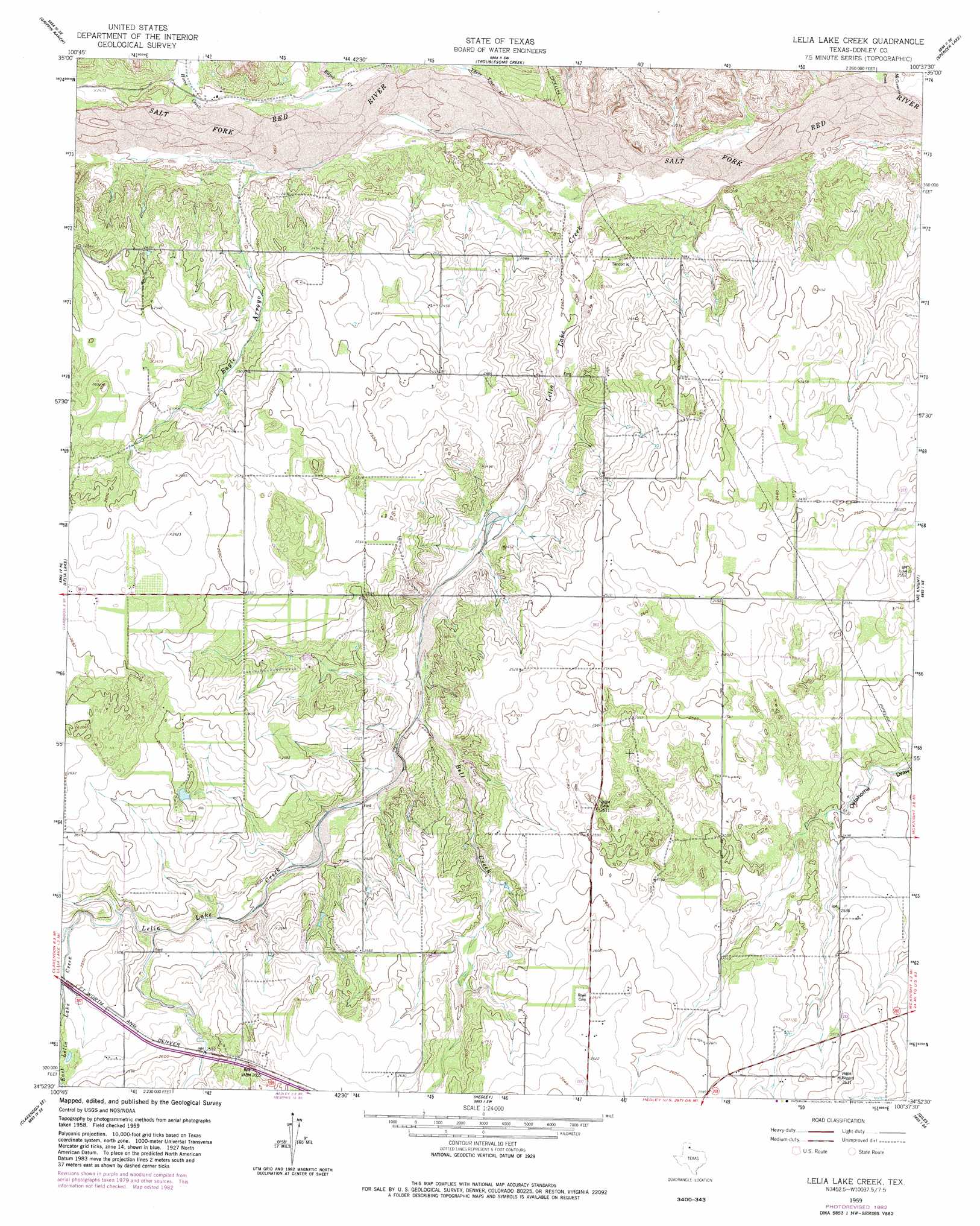
USGS Topo Quad 34100h6 - 1:24,000 scale
| Topo Map Name: | Lelia Lake Creek |
| USGS Topo Quad ID: | 34100h6 |
| Print Size: | ca. 21 1/4" wide x 27" high |
| Southeast Coordinates: | 34.875° N latitude / 100.625° W longitude |
| Map Center Coordinates: | 34.9375° N latitude / 100.6875° W longitude |
| U.S. State: | TX |
| Filename: | o34100h6.jpg |
| Download Map JPG Image: | Lelia Lake Creek topo map 1:24,000 scale |
| Map Type: | Topographic |
| Topo Series: | 7.5´ |
| Map Scale: | 1:24,000 |
| Source of Map Images: | United States Geological Survey (USGS) |
| Alternate Map Versions: |
Lelia Lake Creek TX 1959, updated 1960 Download PDF Buy paper map Lelia Lake Creek TX 2010 Download PDF Buy paper map Lelia Lake Creek TX 2012 Download PDF Buy paper map Lelia Lake Creek TX 2016 Download PDF Buy paper map |
1:24,000 Topo Quads surrounding Lelia Lake Creek
Jericho |
Rockledge |
Alanreed |
Mclean |
Ramsdell |
Roach Ranch |
Griffin Ranch |
Troublesome Creek |
Spencer Lake |
Abra |
Clarendon |
Lelia Lake |
Lelia Lake Creek |
Mcknight |
Quail |
Clarendon Sw |
Clarendon Se |
Hedley |
Giles |
Rolla Sw |
Brice |
Lesley |
Memphis Nw |
Memphis |
Estelline Nw |
> Back to 34100e1 at 1:100,000 scale
> Back to 34100a1 at 1:250,000 scale
> Back to U.S. Topo Maps home
Lelia Lake Creek topo map: Gazetteer
Lelia Lake Creek: Streams
Bell Creek elevation 744m 2440′East Lelia Lake Creek elevation 771m 2529′
Edgel Creek elevation 719m 2358′
Homes Creek elevation 727m 2385′
Lelia Lake Creek elevation 704m 2309′
McCormick Creek elevation 695m 2280′
Three Tree Creek elevation 713m 2339′
West Lelia Lake Creek elevation 771m 2529′
Lelia Lake Creek: Valleys
Eagle Arroyo elevation 726m 2381′Kilfoil Draw elevation 769m 2522′
Lelia Lake Creek digital topo map on disk
Buy this Lelia Lake Creek topo map showing relief, roads, GPS coordinates and other geographical features, as a high-resolution digital map file on DVD: