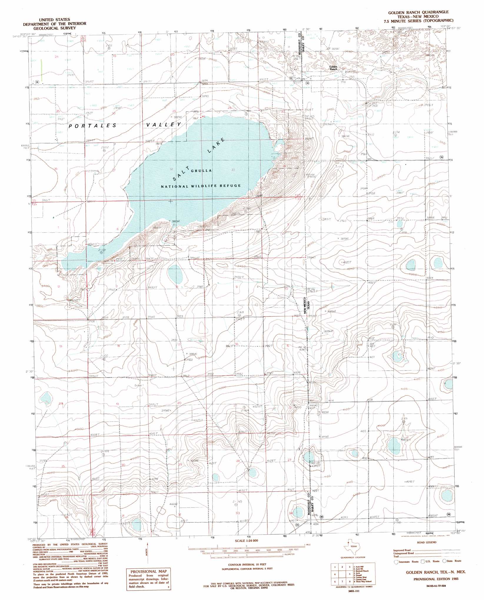
Golden Ranch Topo Map New Mexico
To zoom in, hover over the map of Golden Ranch
USGS Topo Quad 34103a1 - 1:24,000 scale
| Topo Map Name: | Golden Ranch |
| USGS Topo Quad ID: | 34103a1 |
| Print Size: | ca. 21 1/4" wide x 27" high |
| Southeast Coordinates: | 34° N latitude / 103° W longitude |
| Map Center Coordinates: | 34.0625° N latitude / 103.0625° W longitude |
| U.S. States: | NM, TX |
| Filename: | o34103a1.jpg |
| Download Map JPG Image: | Golden Ranch topo map 1:24,000 scale |
| Map Type: | Topographic |
| Topo Series: | 7.5´ |
| Map Scale: | 1:24,000 |
| Source of Map Images: | United States Geological Survey (USGS) |
| Alternate Map Versions: |
Golden Ranch TX 1985, updated 1985 Download PDF Buy paper map Golden Ranch TX 2010 Download PDF Buy paper map Golden Ranch TX 2012 Download PDF Buy paper map Golden Ranch TX 2016 Download PDF Buy paper map |
1:24,000 Topo Quads surrounding Golden Ranch
Oasis State Park |
Midway |
Pleasure Lake |
Lariat |
Progress |
Portales |
Arch Nw |
Arch Ne |
Birdwell Ranch |
Baileyboro Ne |
Portales Se |
Arch |
Golden Ranch |
Stegall |
Baileyboro |
Dora |
Causey West |
Causey East |
Three Way School |
Upper White Lake |
Pep |
Garrison |
Lingo |
Maple |
Enochs |
> Back to 34103a1 at 1:100,000 scale
> Back to 34102a1 at 1:250,000 scale
> Back to U.S. Topo Maps home
Golden Ranch topo map: Gazetteer
Golden Ranch: Lakes
Salt Lake elevation 1178m 3864′Golden Ranch: Parks
Grulla National Wildlife Refuge elevation 1179m 3868′Golden Ranch: Valleys
Portales Valley elevation 1187m 3894′Golden Ranch: Wells
10117 Water Well elevation 1194m 3917′10124 Water Well elevation 1192m 3910′
10125 Water Well elevation 1194m 3917′
10126 Water Well elevation 1194m 3917′
10127 Water Well elevation 1192m 3910′
10128 Water Well elevation 1189m 3900′
10963 Water Well elevation 1195m 3920′
10964 Water Well elevation 1195m 3920′
10965 Water Well elevation 1191m 3907′
10966 Water Well elevation 1192m 3910′
10967 Water Well elevation 1197m 3927′
10968 Water Well elevation 1183m 3881′
10969 Water Well elevation 1210m 3969′
11019 Water Well elevation 1188m 3897′
11026 Water Well elevation 1217m 3992′
11027 Water Well elevation 1198m 3930′
11028 Water Well elevation 1192m 3910′
11029 Water Well elevation 1200m 3937′
11030 Water Well elevation 1199m 3933′
11031 Water Well elevation 1206m 3956′
11032 Water Well elevation 1204m 3950′
11033 Water Well elevation 1214m 3982′
11034 Water Well elevation 1198m 3930′
11035 Water Well elevation 1197m 3927′
11613 Water Well elevation 1196m 3923′
11630 Water Well elevation 1194m 3917′
11720 Water Well elevation 1199m 3933′
11743 Water Well elevation 1200m 3937′
12196 Water Well elevation 1194m 3917′
12201 Water Well elevation 1183m 3881′
12211 Water Well elevation 1194m 3917′
12212 Water Well elevation 1188m 3897′
12239 Water Well elevation 1194m 3917′
12403 Water Well elevation 1194m 3917′
12412 Water Well elevation 1196m 3923′
12413 Water Well elevation 1191m 3907′
12514 Water Well elevation 1194m 3917′
12517 Water Well elevation 1192m 3910′
12680 Water Well elevation 1197m 3927′
12687 Water Well elevation 1188m 3897′
12698 Water Well elevation 1190m 3904′
P-3293-S-2 Water Well elevation 1188m 3897′
Golden Ranch digital topo map on disk
Buy this Golden Ranch topo map showing relief, roads, GPS coordinates and other geographical features, as a high-resolution digital map file on DVD: