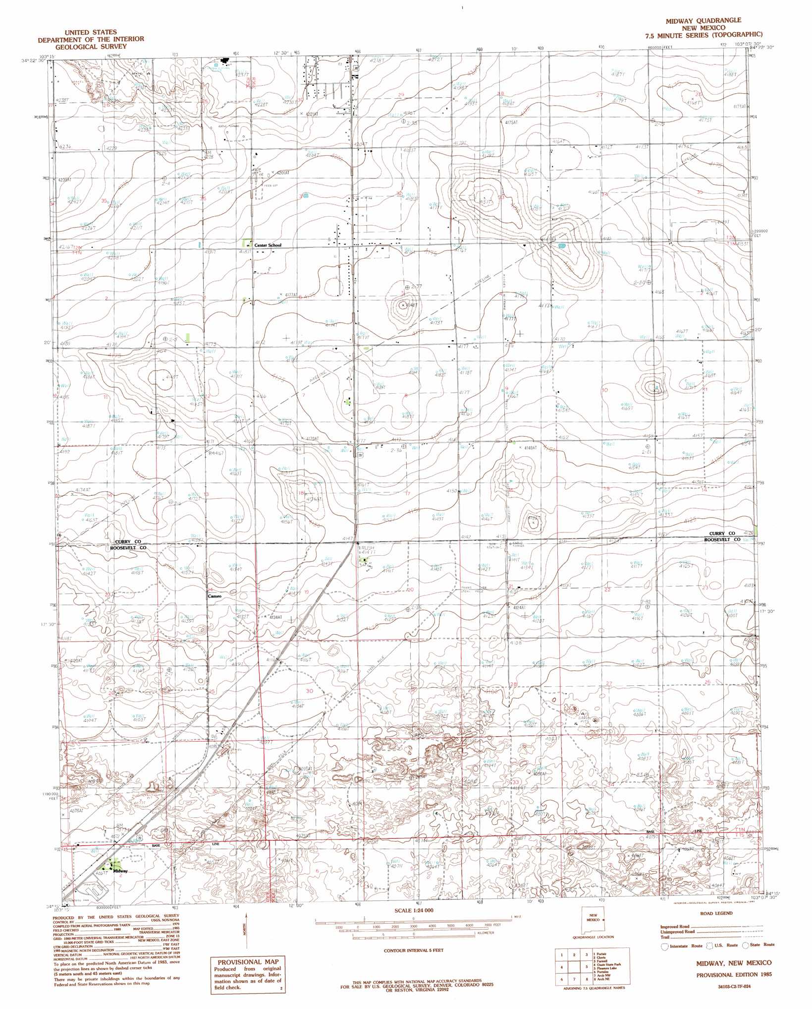
Midway Topo Map New Mexico
To zoom in, hover over the map of Midway
USGS Topo Quad 34103c2 - 1:24,000 scale
| Topo Map Name: | Midway |
| USGS Topo Quad ID: | 34103c2 |
| Print Size: | ca. 21 1/4" wide x 27" high |
| Southeast Coordinates: | 34.25° N latitude / 103.125° W longitude |
| Map Center Coordinates: | 34.3125° N latitude / 103.1875° W longitude |
| U.S. State: | NM |
| Filename: | o34103c2.jpg |
| Download Map JPG Image: | Midway topo map 1:24,000 scale |
| Map Type: | Topographic |
| Topo Series: | 7.5´ |
| Map Scale: | 1:24,000 |
| Source of Map Images: | United States Geological Survey (USGS) |
| Alternate Map Versions: |
Midway NM 1985, updated 1985 Download PDF Buy paper map Midway NM 2010 Download PDF Buy paper map Midway NM 2013 Download PDF Buy paper map Midway NM 2017 Download PDF Buy paper map |
1:24,000 Topo Quads surrounding Midway
Hammond Ranch Sw |
Garrett Ranch |
Ned Houk Park |
Pleasant Hill |
Bovina |
Saint Vrain |
Portair |
Clovis |
Farwell |
Oklahoma Lane |
Portair Sw |
Oasis State Park |
Midway |
Pleasure Lake |
Lariat |
Bethel |
Portales |
Arch Nw |
Arch Ne |
Birdwell Ranch |
Delphos |
Portales Se |
Arch |
Golden Ranch |
Stegall |
> Back to 34103a1 at 1:100,000 scale
> Back to 34102a1 at 1:250,000 scale
> Back to U.S. Topo Maps home
Midway topo map: Gazetteer
Midway: Parks
Eastern New Mexico State Park (historical) elevation 1239m 4064′Midway: Populated Places
Cameo elevation 1259m 4130′Midway elevation 1241m 4071′
Midway: Wells
10022 Water Well elevation 1266m 4153′10069 Water Well elevation 1240m 4068′
10807 Water Well elevation 1239m 4064′
10831 Water Well elevation 1242m 4074′
10833 Water Well elevation 1240m 4068′
11635 Water Well elevation 1260m 4133′
11696 Water Well elevation 1254m 4114′
11710 Water Well elevation 1254m 4114′
11711 Water Well elevation 1251m 4104′
11712 Water Well elevation 1244m 4081′
11730 Water Well elevation 1238m 4061′
12002 Water Well elevation 1249m 4097′
12167 Water Well elevation 1241m 4071′
12188 Water Well elevation 1240m 4068′
12241 Water Well elevation 1248m 4094′
12260 Water Well elevation 1244m 4081′
12385 Water Well elevation 1241m 4071′
12691 Water Well elevation 1251m 4104′
12710 Water Well elevation 1254m 4114′
CC-575 Water Well elevation 1274m 4179′
Midway digital topo map on disk
Buy this Midway topo map showing relief, roads, GPS coordinates and other geographical features, as a high-resolution digital map file on DVD: