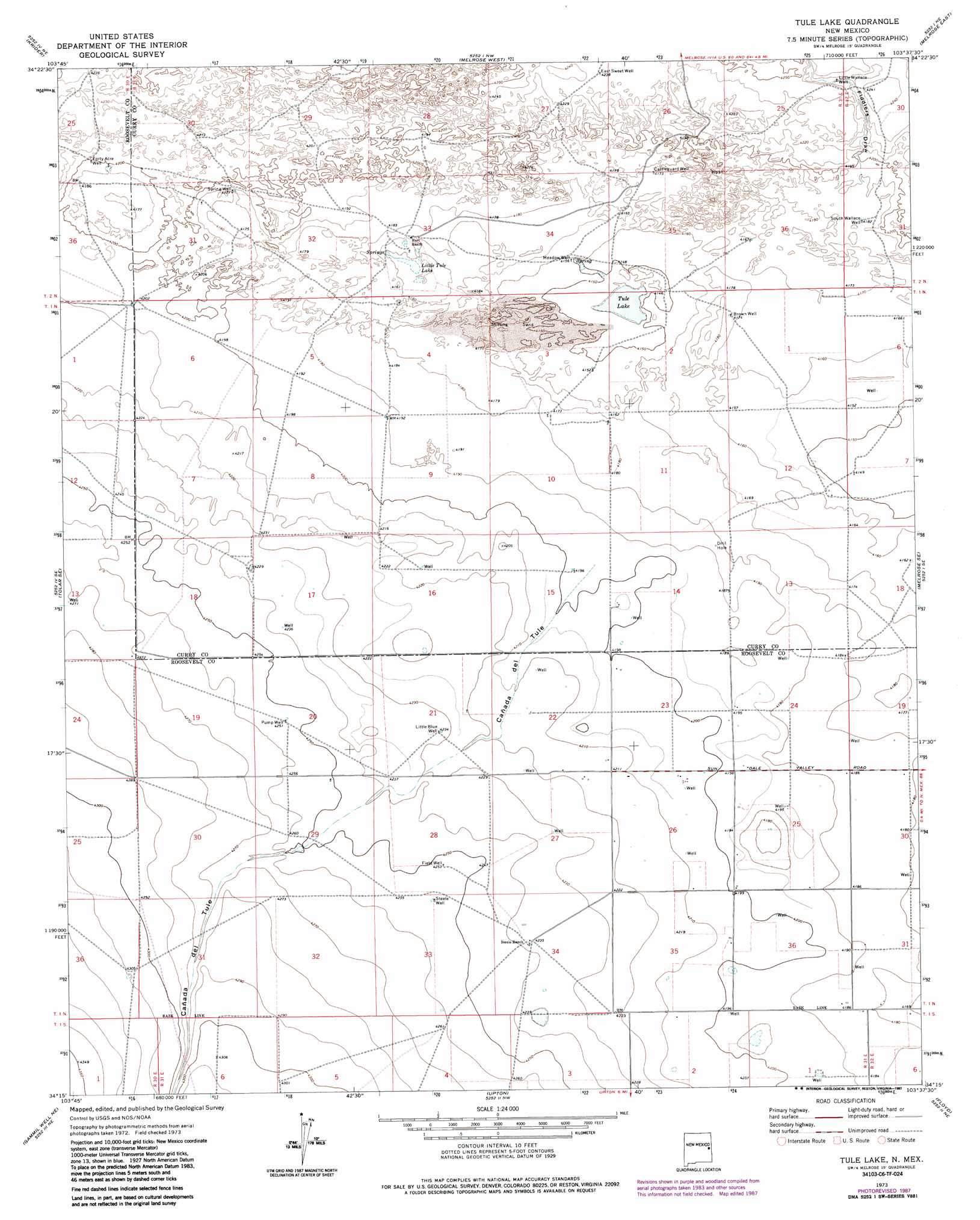
Tule Lake Topo Map New Mexico
To zoom in, hover over the map of Tule Lake
USGS Topo Quad 34103c6 - 1:24,000 scale
| Topo Map Name: | Tule Lake |
| USGS Topo Quad ID: | 34103c6 |
| Print Size: | ca. 21 1/4" wide x 27" high |
| Southeast Coordinates: | 34.25° N latitude / 103.625° W longitude |
| Map Center Coordinates: | 34.3125° N latitude / 103.6875° W longitude |
| U.S. State: | NM |
| Filename: | o34103c6.jpg |
| Download Map JPG Image: | Tule Lake topo map 1:24,000 scale |
| Map Type: | Topographic |
| Topo Series: | 7.5´ |
| Map Scale: | 1:24,000 |
| Source of Map Images: | United States Geological Survey (USGS) |
| Alternate Map Versions: |
Tule Lake NM 1973, updated 1975 Download PDF Buy paper map Tule Lake NM 1973, updated 1987 Download PDF Buy paper map Tule Lake NM 2010 Download PDF Buy paper map Tule Lake NM 2013 Download PDF Buy paper map Tule Lake NM 2017 Download PDF Buy paper map |
1:24,000 Topo Quads surrounding Tule Lake
Peach Canyon |
House Se |
Field Sw |
Field Se |
Hammond Ranch Sw |
Tolar |
Krider |
Melrose West |
Melrose East |
Saint Vrain |
Tolar Sw |
Tolar Se |
Tule Lake |
Melrose Se |
Portair Sw |
Gammil Well |
Gammil Well Ne |
Upton |
Floyd |
Bethel |
Rippee Ranch |
Gammil Well Se |
Lewiston Lake |
Floyd Se |
Delphos |
> Back to 34103a1 at 1:100,000 scale
> Back to 34102a1 at 1:250,000 scale
> Back to U.S. Topo Maps home
Tule Lake topo map: Gazetteer
Tule Lake: Lakes
Little Tule Lake elevation 1268m 4160′Tule Lake elevation 1260m 4133′
Tule Lake: Streams
Cañada del Tule elevation 1279m 4196′Tule Lake: Valleys
Fiddlers Draw elevation 1277m 4189′Tule Lake: Wells
05082 Water Well elevation 1296m 4251′05083 Water Well elevation 1298m 4258′
05084 Water Well elevation 1301m 4268′
05090 Water Well elevation 1308m 4291′
05095 Water Well elevation 1317m 4320′
06022 Water Well elevation 1303m 4274′
06027 Water Well elevation 1305m 4281′
10001 Water Well elevation 1274m 4179′
10002 Water Well elevation 1281m 4202′
10004 Water Well elevation 1292m 4238′
10005 Water Well elevation 1280m 4199′
10478 Water Well elevation 1279m 4196′
10479 Water Well elevation 1278m 4192′
10582 Water Well elevation 1278m 4192′
10589 Water Well elevation 1299m 4261′
10746 Water Well elevation 1278m 4192′
10747 Water Well elevation 1276m 4186′
10748 Water Well elevation 1278m 4192′
11626 Water Well elevation 1279m 4196′
11627 Water Well elevation 1285m 4215′
11643 Water Well elevation 1278m 4192′
12519 Water Well elevation 1301m 4268′
12658 Water Well elevation 1304m 4278′
12659 Water Well elevation 1310m 4297′
12699 Water Well elevation 1300m 4265′
12700 Water Well elevation 1299m 4261′
12701 Water Well elevation 1303m 4274′
Brown Well elevation 1273m 4176′
Cattleguard Well elevation 1274m 4179′
East Sweet Well elevation 1290m 4232′
Field Well elevation 1297m 4255′
Forty Acre Well elevation 1280m 4199′
Little Blue Well elevation 1291m 4235′
Little Wallace Well elevation 1289m 4229′
Meadow Well elevation 1265m 4150′
Pump Well elevation 1297m 4255′
South Wallace Well elevation 1276m 4186′
Steele Well elevation 1298m 4258′
Tule Lake digital topo map on disk
Buy this Tule Lake topo map showing relief, roads, GPS coordinates and other geographical features, as a high-resolution digital map file on DVD: