Clovis Topo Map New Mexico
To zoom in, hover over the map of Clovis
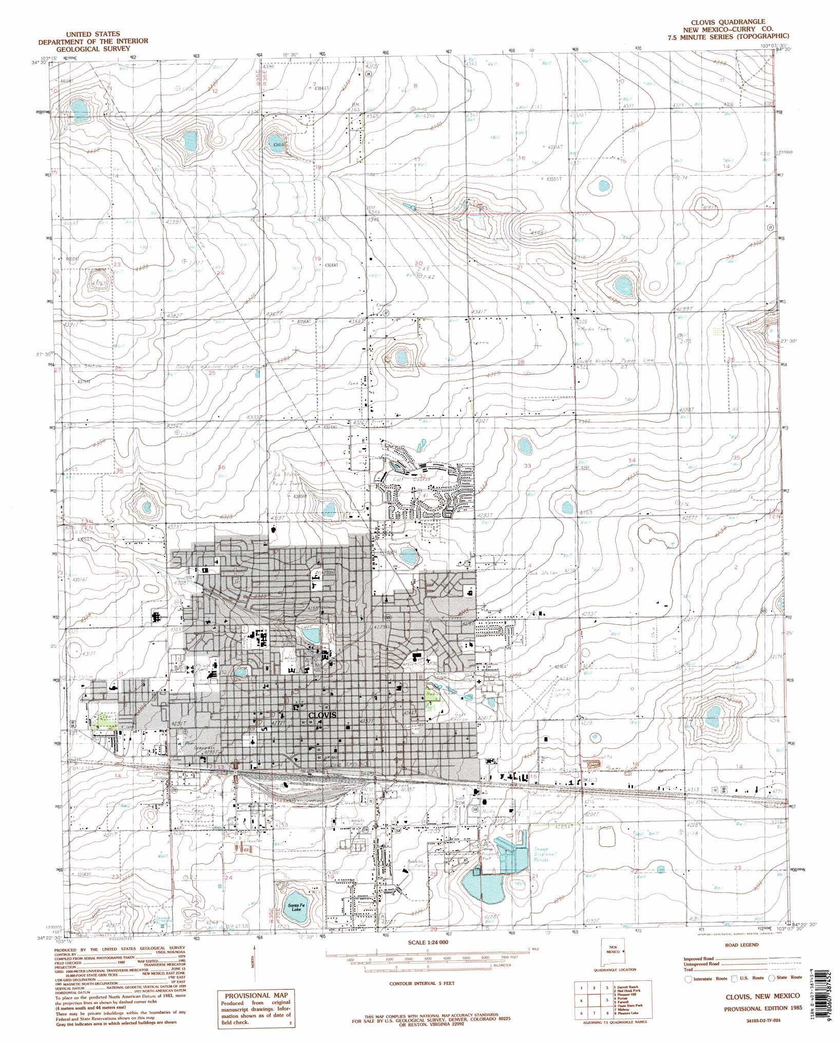
USGS Topo Quad 34103d2 - 1:24,000 scale
| Topo Map Name: | Clovis |
| USGS Topo Quad ID: | 34103d2 |
| Print Size: | ca. 21 1/4" wide x 27" high |
| Southeast Coordinates: | 34.375° N latitude / 103.125° W longitude |
| Map Center Coordinates: | 34.4375° N latitude / 103.1875° W longitude |
| U.S. State: | NM |
| Filename: | o34103d2.jpg |
| Download Map JPG Image: | Clovis topo map 1:24,000 scale |
| Map Type: | Topographic |
| Topo Series: | 7.5´ |
| Map Scale: | 1:24,000 |
| Source of Map Images: | United States Geological Survey (USGS) |
| Alternate Map Versions: |
Clovis NM 1985, updated 1985 Download PDF Buy paper map Clovis NM 2010 Download PDF Buy paper map Clovis NM 2013 Download PDF Buy paper map Clovis NM 2017 Download PDF Buy paper map |
1:24,000 Topo Quads surrounding Clovis
Hammond Ranch |
Smith Ranch |
Pleasant Hill Nw |
Pleasant Hill Ne |
Rhea |
Hammond Ranch Sw |
Garrett Ranch |
Ned Houk Park |
Pleasant Hill |
Bovina |
Saint Vrain |
Portair |
Clovis |
Farwell |
Oklahoma Lane |
Portair Sw |
Oasis State Park |
Midway |
Pleasure Lake |
Lariat |
Bethel |
Portales |
Arch Nw |
Arch Ne |
Birdwell Ranch |
> Back to 34103a1 at 1:100,000 scale
> Back to 34102a1 at 1:250,000 scale
> Back to U.S. Topo Maps home
Clovis topo map: Gazetteer
Clovis: Airports
Aero Tech Inc Airport elevation 1290m 4232′Clovis: Lakes
Santa Fe Lake elevation 1286m 4219′Clovis: Parks
Clovis Historical Marker elevation 1301m 4268′Hillcrest Park elevation 1295m 4248′
Potter Park elevation 1307m 4288′
Clovis: Populated Places
Clovis elevation 1301m 4268′Clovis: Post Offices
Clovis Post Office elevation 1301m 4268′Clovis: Reservoirs
Greene Lake elevation 1300m 4265′Clovis: Wells
10033 Water Well elevation 1296m 4251′10034 Water Well elevation 1292m 4238′
10035 Water Well elevation 1292m 4238′
10036 Water Well elevation 1284m 4212′
10037 Water Well elevation 1288m 4225′
10038 Water Well elevation 1281m 4202′
10060 Water Well elevation 1337m 4386′
10061 Water Well elevation 1323m 4340′
10062 Water Well elevation 1323m 4340′
10063 Water Well elevation 1316m 4317′
10064 Water Well elevation 1324m 4343′
10065 Water Well elevation 1323m 4340′
10066 Water Well elevation 1312m 4304′
10067 Water Well elevation 1327m 4353′
10068 Water Well elevation 1317m 4320′
10069 Water Well elevation 1300m 4265′
10086 Water Well elevation 1284m 4212′
10088 Water Well elevation 1289m 4229′
10109 Water Well elevation 1302m 4271′
10154 Water Well elevation 1323m 4340′
10158 Water Well elevation 1308m 4291′
10165 Water Well elevation 1289m 4229′
10437 Water Well elevation 1343m 4406′
10442 Water Well elevation 1332m 4370′
10443 Water Well elevation 1328m 4356′
10444 Water Well elevation 1315m 4314′
10445 Water Well elevation 1312m 4304′
10447 Water Well elevation 1327m 4353′
10448 Water Well elevation 1326m 4350′
10561 Water Well elevation 1298m 4258′
10564 Water Well elevation 1304m 4278′
10748 Water Well elevation 1334m 4376′
10749 Water Well elevation 1318m 4324′
10772 Water Well elevation 1283m 4209′
10937 Water Well elevation 1302m 4271′
10938 Water Well elevation 1311m 4301′
10939 Water Well elevation 1286m 4219′
10940 Water Well elevation 1289m 4229′
11329 Water Well elevation 1327m 4353′
CC-92 Water Well elevation 1304m 4278′
Clovis digital topo map on disk
Buy this Clovis topo map showing relief, roads, GPS coordinates and other geographical features, as a high-resolution digital map file on DVD: