Lovelady Draw Topo Map New Mexico
To zoom in, hover over the map of Lovelady Draw
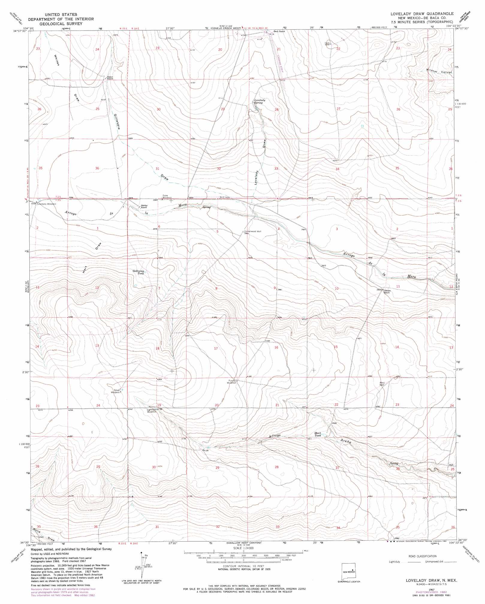
USGS Topo Quad 34104a4 - 1:24,000 scale
| Topo Map Name: | Lovelady Draw |
| USGS Topo Quad ID: | 34104a4 |
| Print Size: | ca. 21 1/4" wide x 27" high |
| Southeast Coordinates: | 34° N latitude / 104.375° W longitude |
| Map Center Coordinates: | 34.0625° N latitude / 104.4375° W longitude |
| U.S. State: | NM |
| Filename: | o34104a4.jpg |
| Download Map JPG Image: | Lovelady Draw topo map 1:24,000 scale |
| Map Type: | Topographic |
| Topo Series: | 7.5´ |
| Map Scale: | 1:24,000 |
| Source of Map Images: | United States Geological Survey (USGS) |
| Alternate Map Versions: |
Lovelady Draw NM 1967, updated 1971 Download PDF Buy paper map Lovelady Draw NM 1967, updated 1982 Download PDF Buy paper map Lovelady Draw NM 2010 Download PDF Buy paper map Lovelady Draw NM 2013 Download PDF Buy paper map Lovelady Draw NM 2017 Download PDF Buy paper map |
1:24,000 Topo Quads surrounding Lovelady Draw
El Morro Mesa |
Horney Ranch |
West Camp |
Alamo Ranch |
Bonner Lake |
The Old Dry Lake |
Dunlap Ne |
Conejo Creek West |
Conejo Creek East |
Eighteenmile Hill |
Devils Well |
Dunlap |
Lovelady Draw |
La Espia Peak |
Cooley Lake |
Mesa |
Dunlap Sill |
Swallow Nest Canyon |
Deering Place |
Hernandez Lake |
Mesa Sw |
Mesa Se |
Shannon Draw |
Cottonwood Draw |
Haystack Butte |
> Back to 34104a1 at 1:100,000 scale
> Back to 34104a1 at 1:250,000 scale
> Back to U.S. Topo Maps home
Lovelady Draw topo map: Gazetteer
Lovelady Draw: Reservoirs
Galloway Tank elevation 1239m 4064′Short Tank elevation 1220m 4002′
Lovelady Draw: Springs
Lovelady Spring elevation 1236m 4055′Lovelady Springs elevation 1255m 4117′
Lovelady Draw: Valleys
Gillespie Draw elevation 1196m 3923′Hart Draw elevation 1212m 3976′
Lovelady Draw elevation 1199m 3933′
Whites Draw elevation 1225m 4019′
Lovelady Draw: Wells
Cottonwood Well elevation 1202m 3943′Lovelady Draw digital topo map on disk
Buy this Lovelady Draw topo map showing relief, roads, GPS coordinates and other geographical features, as a high-resolution digital map file on DVD: