Camaleon Draw East Topo Map New Mexico
To zoom in, hover over the map of Camaleon Draw East
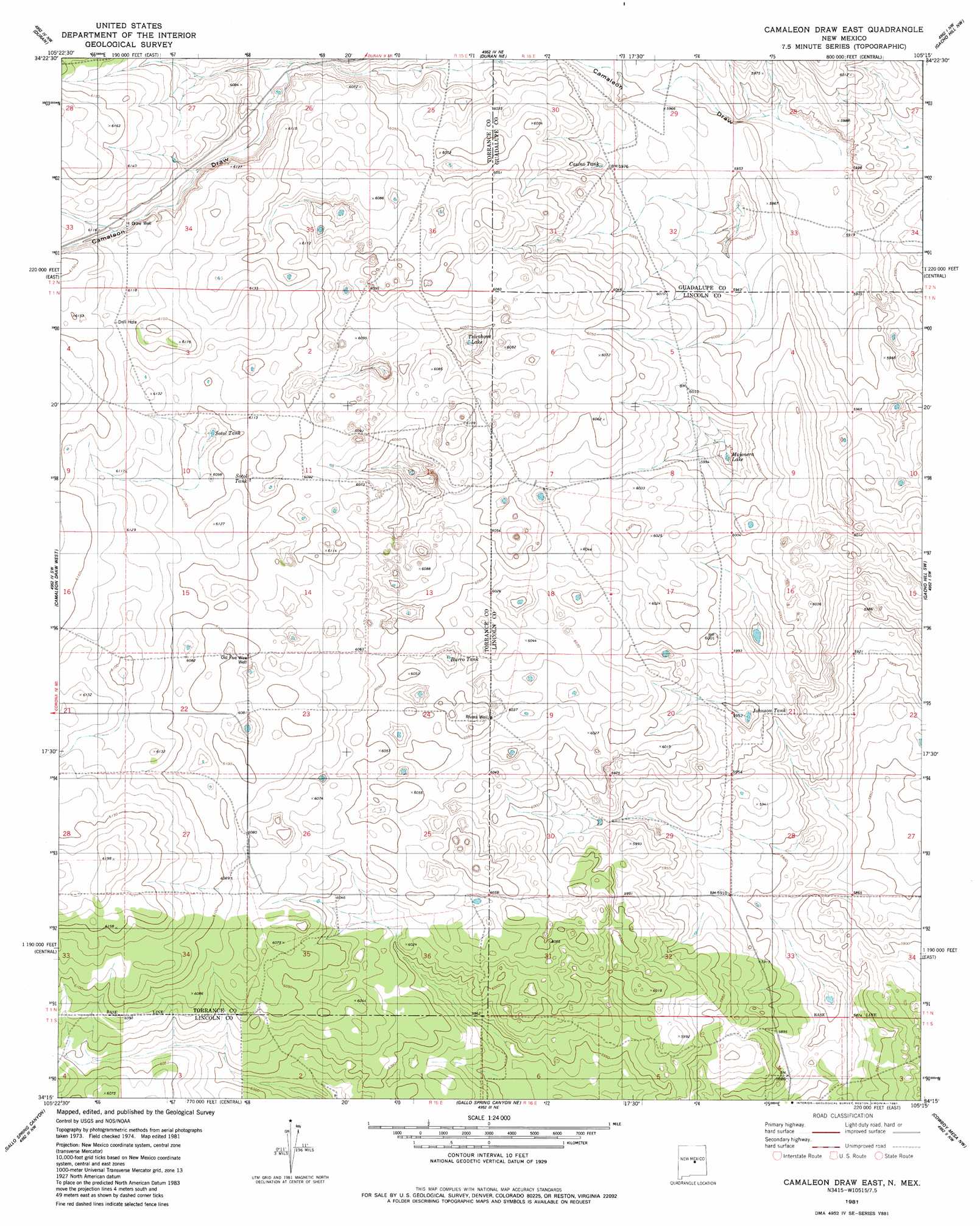
USGS Topo Quad 34105c3 - 1:24,000 scale
| Topo Map Name: | Camaleon Draw East |
| USGS Topo Quad ID: | 34105c3 |
| Print Size: | ca. 21 1/4" wide x 27" high |
| Southeast Coordinates: | 34.25° N latitude / 105.25° W longitude |
| Map Center Coordinates: | 34.3125° N latitude / 105.3125° W longitude |
| U.S. State: | NM |
| Filename: | o34105c3.jpg |
| Download Map JPG Image: | Camaleon Draw East topo map 1:24,000 scale |
| Map Type: | Topographic |
| Topo Series: | 7.5´ |
| Map Scale: | 1:24,000 |
| Source of Map Images: | United States Geological Survey (USGS) |
| Alternate Map Versions: |
Camaleon Draw East NM 1981, updated 1981 Download PDF Buy paper map Camaleon Draw East NM 2010 Download PDF Buy paper map Camaleon Draw East NM 2013 Download PDF Buy paper map Camaleon Draw East NM 2017 Download PDF Buy paper map |
1:24,000 Topo Quads surrounding Camaleon Draw East
Negra Se |
Dunlap Ranch |
Tejon |
Vaughn |
Long Draw |
Cedarvale Ne |
Duran |
Duran Ne |
Gacho Hill Nw |
Gacho Hill |
Corono North |
Camaleon Draw West |
Camaleon Draw East |
Gacho Hill Sw |
Gacho Hill Se |
Corona South |
Gallo Spring Canyon |
Gallo Spring Canyon Ne |
Cowboy Mesa Nw |
Cowboy Mesa Ne |
Pelan Hill |
Red Bluff Draw West |
Red Bluff Draw East |
Cowboy Mesa Sw |
Cowboy Mesa |
> Back to 34105a1 at 1:100,000 scale
> Back to 34104a1 at 1:250,000 scale
> Back to U.S. Topo Maps home
Camaleon Draw East topo map: Gazetteer
Camaleon Draw East: Lakes
Telephone Lake elevation 1832m 6010′Camaleon Draw East: Reservoirs
Burro Tank elevation 1832m 6010′Casino Tank elevation 1816m 5958′
Johnson Tank elevation 1809m 5935′
Jojonera Lake elevation 1811m 5941′
Sotol Tank elevation 1858m 6095′
Sotol Tank elevation 1851m 6072′
Camaleon Draw East: Wells
Draw Well elevation 1856m 6089′Old Five Wire Well elevation 1849m 6066′
Rivera Well elevation 1841m 6040′
Camaleon Draw East digital topo map on disk
Buy this Camaleon Draw East topo map showing relief, roads, GPS coordinates and other geographical features, as a high-resolution digital map file on DVD: