Chupadera Spring Topo Map New Mexico
To zoom in, hover over the map of Chupadera Spring
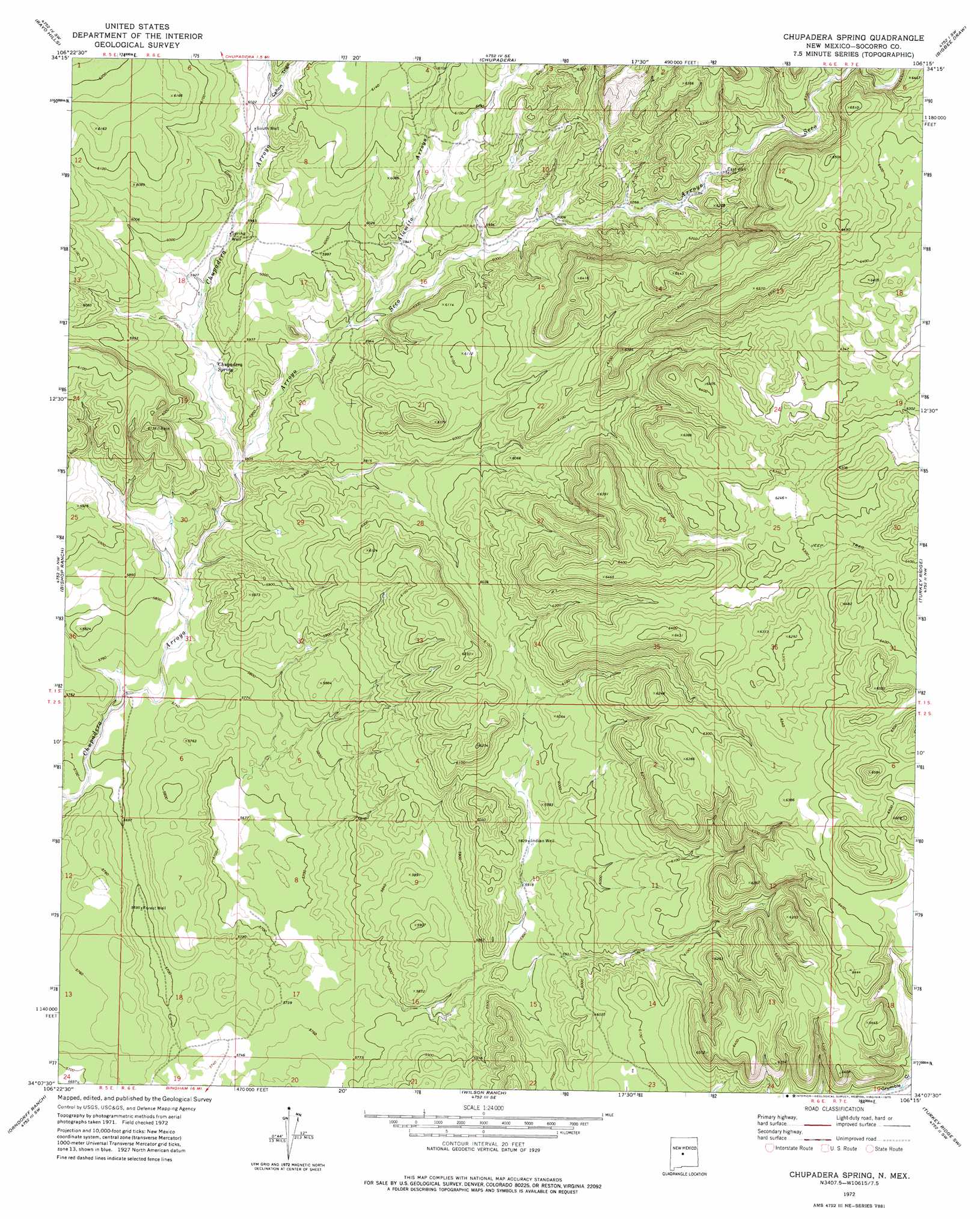
USGS Topo Quad 34106b3 - 1:24,000 scale
| Topo Map Name: | Chupadera Spring |
| USGS Topo Quad ID: | 34106b3 |
| Print Size: | ca. 21 1/4" wide x 27" high |
| Southeast Coordinates: | 34.125° N latitude / 106.25° W longitude |
| Map Center Coordinates: | 34.1875° N latitude / 106.3125° W longitude |
| U.S. State: | NM |
| Filename: | o34106b3.jpg |
| Download Map JPG Image: | Chupadera Spring topo map 1:24,000 scale |
| Map Type: | Topographic |
| Topo Series: | 7.5´ |
| Map Scale: | 1:24,000 |
| Source of Map Images: | United States Geological Survey (USGS) |
| Alternate Map Versions: |
Chupadera Spring NM 1972, updated 1975 Download PDF Buy paper map Chupadera Spring NM 2010 Download PDF Buy paper map Chupadera Spring NM 2013 Download PDF Buy paper map Chupadera Spring NM 2017 Download PDF Buy paper map |
1:24,000 Topo Quads surrounding Chupadera Spring
Becker |
Scholle |
Abo |
Mesa Draw |
Round Top |
Cerro Montoso |
Rayo Hills |
Chupadera |
Bigbee Draw |
Gran Quivira |
Sierra Larga North |
Bishop Ranch |
Chupadera Spring |
Turkey Ridge |
Turkey Ridge Ne |
Sierra Larga South |
Orndorff Ranch |
Wilson Ranch |
Turkey Ridge Sw |
Cat Mesa |
Prairie Spring |
Wrye Peak Nw |
Wrye Peak |
Cooper Canyon |
Lovelace Mesa |
> Back to 34106a1 at 1:100,000 scale
> Back to 34106a1 at 1:250,000 scale
> Back to U.S. Topo Maps home
Chupadera Spring topo map: Gazetteer
Chupadera Spring: Springs
Chupadera Spring elevation 1791m 5875′Chupadera Spring: Streams
Alamito Arroyo elevation 1798m 5898′Arroyo Seco elevation 1775m 5823′
Chupadera Spring: Valleys
Cañon Trigo elevation 1832m 6010′Chupadera Spring: Wells
East Well elevation 1877m 6158′Forest Well elevation 1736m 5695′
Indian Well elevation 1809m 5935′
North Well elevation 1963m 6440′
South Well elevation 1822m 5977′
Spring Well elevation 1811m 5941′
Chupadera Spring digital topo map on disk
Buy this Chupadera Spring topo map showing relief, roads, GPS coordinates and other geographical features, as a high-resolution digital map file on DVD: