Scholle Topo Map New Mexico
To zoom in, hover over the map of Scholle
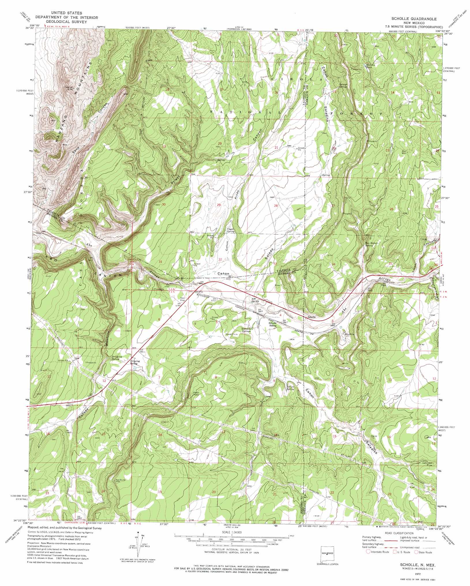
USGS Topo Quad 34106d4 - 1:24,000 scale
| Topo Map Name: | Scholle |
| USGS Topo Quad ID: | 34106d4 |
| Print Size: | ca. 21 1/4" wide x 27" high |
| Southeast Coordinates: | 34.375° N latitude / 106.375° W longitude |
| Map Center Coordinates: | 34.4375° N latitude / 106.4375° W longitude |
| U.S. State: | NM |
| Filename: | o34106d4.jpg |
| Download Map JPG Image: | Scholle topo map 1:24,000 scale |
| Map Type: | Topographic |
| Topo Series: | 7.5´ |
| Map Scale: | 1:24,000 |
| Source of Map Images: | United States Geological Survey (USGS) |
| Alternate Map Versions: |
Scholle NM 1972, updated 1975 Download PDF Buy paper map Scholle NM 1995, updated 1998 Download PDF Buy paper map Scholle NM 2011 Download PDF Buy paper map Scholle NM 2013 Download PDF Buy paper map Scholle NM 2017 Download PDF Buy paper map |
| FStopo: | US Forest Service topo Scholle is available: Download FStopo PDF Download FStopo TIF |
1:24,000 Topo Quads surrounding Scholle
Tome |
Tome Ne |
Capilla Peak |
Torreon |
Ewing |
Turn |
Tome Se |
Manzano Peak |
Punta De Agua |
Mountainair |
Black Butte |
Becker |
Scholle |
Abo |
Mesa Draw |
Becker Sw |
Cerro Montoso |
Rayo Hills |
Chupadera |
Bigbee Draw |
Sierra De La Cruz |
Sierra Larga North |
Bishop Ranch |
Chupadera Spring |
Turkey Ridge |
> Back to 34106a1 at 1:100,000 scale
> Back to 34106a1 at 1:250,000 scale
> Back to U.S. Topo Maps home
Scholle topo map: Gazetteer
Scholle: Mines
Abo Mine elevation 1792m 5879′Gabaldon Mine elevation 1874m 6148′
Jack Rabbit Claim elevation 1772m 5813′
Scholle Claim Group elevation 1812m 5944′
Scholle Plant Mine elevation 1816m 5958′
Scholle: Populated Places
Scholle elevation 1779m 5836′Scholle: Post Offices
Scholle Post Office (historical) elevation 1779m 5836′Scholle: Reservoirs
Mexican Tank elevation 1954m 6410′Scholle: Springs
Abo Spring elevation 1757m 5764′Bustamonte Spring elevation 1782m 5846′
Coyote Spring elevation 1764m 5787′
Dripping Spring elevation 1755m 5757′
Indian Spring elevation 1808m 5931′
Little Sand Spring elevation 1818m 5964′
Saladito Spring elevation 1786m 5859′
Saladito Springs elevation 1774m 5820′
San Rafael Spring elevation 1817m 5961′
Spencer Spring elevation 1871m 6138′
Vega Spring elevation 1801m 5908′
Scholle: Summits
Red Butte elevation 1924m 6312′Scholle: Valleys
Cañada Montosa elevation 1701m 5580′Cañon Arado elevation 1748m 5734′
Canon Espinoso elevation 1811m 5941′
Cañon Latigo elevation 1810m 5938′
Cañon Saladito elevation 1804m 5918′
Cañon Saladito elevation 1756m 5761′
Cañon Salado elevation 1737m 5698′
Priest Canyon elevation 1694m 5557′
Sand Canyon elevation 1661m 5449′
Scholle: Wells
Abo Well elevation 1901m 6236′Contrers 2 Water Well elevation 1838m 6030′
RG 34050 Water Well elevation 1780m 5839′
Saladito Well elevation 1787m 5862′
Scholle digital topo map on disk
Buy this Scholle topo map showing relief, roads, GPS coordinates and other geographical features, as a high-resolution digital map file on DVD: