Mount Washington Topo Map New Mexico
To zoom in, hover over the map of Mount Washington
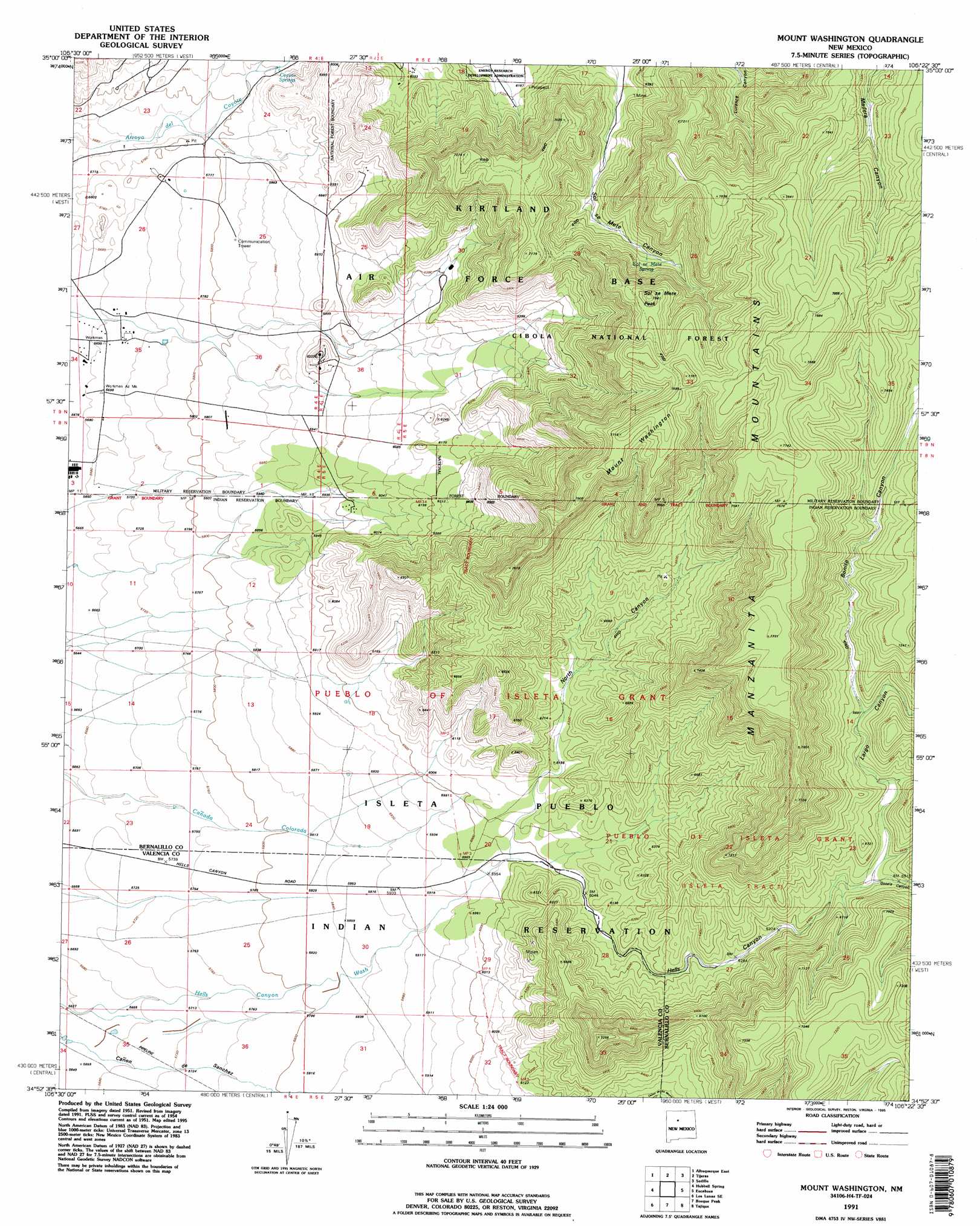
USGS Topo Quad 34106h4 - 1:24,000 scale
| Topo Map Name: | Mount Washington |
| USGS Topo Quad ID: | 34106h4 |
| Print Size: | ca. 21 1/4" wide x 27" high |
| Southeast Coordinates: | 34.875° N latitude / 106.375° W longitude |
| Map Center Coordinates: | 34.9375° N latitude / 106.4375° W longitude |
| U.S. State: | NM |
| Filename: | o34106h4.jpg |
| Download Map JPG Image: | Mount Washington topo map 1:24,000 scale |
| Map Type: | Topographic |
| Topo Series: | 7.5´ |
| Map Scale: | 1:24,000 |
| Source of Map Images: | United States Geological Survey (USGS) |
| Alternate Map Versions: |
Mount Washington NM 1954, updated 1955 Download PDF Buy paper map Mount Washington NM 1954, updated 1963 Download PDF Buy paper map Mount Washington NM 1954, updated 1969 Download PDF Buy paper map Mount Washington NM 1954, updated 1992 Download PDF Buy paper map Mount Washington NM 1964, updated 1966 Download PDF Buy paper map Mount Washington NM 1964, updated 1978 Download PDF Buy paper map Mount Washington NM 1991, updated 1995 Download PDF Buy paper map Mount Washington NM 1995, updated 1998 Download PDF Buy paper map Mount Washington NM 2011 Download PDF Buy paper map Mount Washington NM 2013 Download PDF Buy paper map Mount Washington NM 2017 Download PDF Buy paper map |
| FStopo: | US Forest Service topo Mount Washington is available: Download FStopo PDF Download FStopo TIF |
1:24,000 Topo Quads surrounding Mount Washington
Los Griegos |
Alameda |
Sandia Crest |
Sandia Park |
San Pedro |
Albuquerque West |
Albuquerque East |
Tijeras |
Sedillo |
Edgewood |
Isleta |
Hubbell Spring |
Mount Washington |
Escabosa |
Chilili |
Los Lunas |
Los Lunas Se |
Bosque Peak |
Tajique |
Milbourn Ranch |
Tome |
Tome Ne |
Capilla Peak |
Torreon |
Ewing |
> Back to 34106e1 at 1:100,000 scale
> Back to 34106a1 at 1:250,000 scale
> Back to U.S. Topo Maps home
Mount Washington topo map: Gazetteer
Mount Washington: Mines
Belvidere Group elevation 1883m 6177′Eighty-Five Prospect elevation 1925m 6315′
Galena King elevation 2134m 7001′
Hardinand Claim elevation 1857m 6092′
Isleta Quartz Mine elevation 1905m 6250′
Milagros Mine elevation 1839m 6033′
Moore Prospect elevation 1852m 6076′
Quail Lode elevation 1853m 6079′
River View Placer elevation 1797m 5895′
Mount Washington: Springs
Coyote Springs elevation 1784m 5853′Sol se Mete Spring elevation 2037m 6683′
Mount Washington: Summits
Mount Washington elevation 2347m 7700′Sol se Mete Peak elevation 2285m 7496′
Mount Washington: Valleys
Bonito Canyon elevation 2046m 6712′Gotera Canyon elevation 1975m 6479′
Hells Canyon elevation 1823m 5980′
Largo Canyon elevation 1975m 6479′
North Canyon elevation 1823m 5980′
Mount Washington: Wells
Isleta Well elevation 1772m 5813′Mount Washington digital topo map on disk
Buy this Mount Washington topo map showing relief, roads, GPS coordinates and other geographical features, as a high-resolution digital map file on DVD: