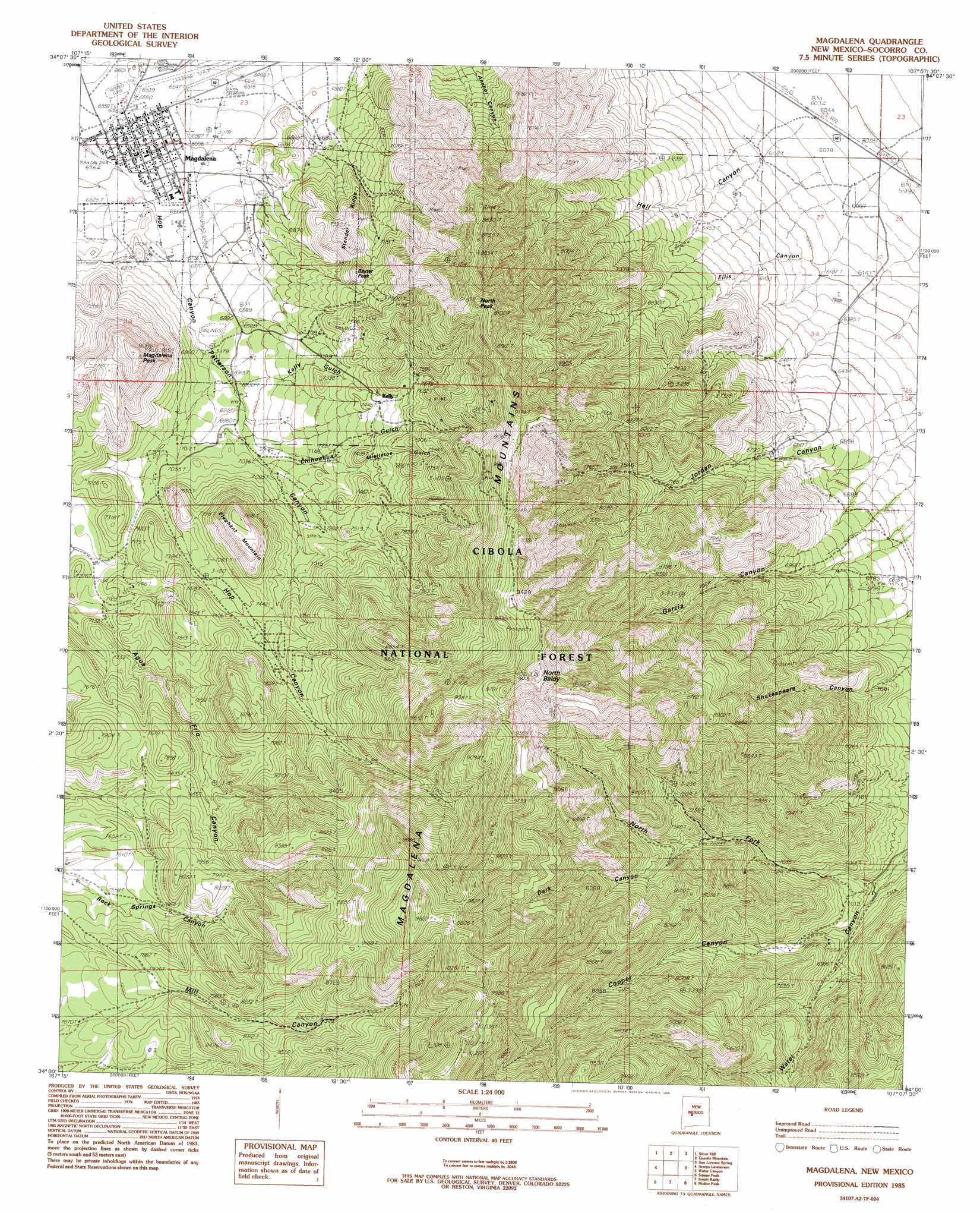
Magdalena Topo Map New Mexico
To zoom in, hover over the map of Magdalena
USGS Topo Quad 34107a2 - 1:24,000 scale
| Topo Map Name: | Magdalena |
| USGS Topo Quad ID: | 34107a2 |
| Print Size: | ca. 21 1/4" wide x 27" high |
| Southeast Coordinates: | 34° N latitude / 107.125° W longitude |
| Map Center Coordinates: | 34.0625° N latitude / 107.1875° W longitude |
| U.S. State: | NM |
| Filename: | o34107a2.jpg |
| Download Map JPG Image: | Magdalena topo map 1:24,000 scale |
| Map Type: | Topographic |
| Topo Series: | 7.5´ |
| Map Scale: | 1:24,000 |
| Source of Map Images: | United States Geological Survey (USGS) |
| Alternate Map Versions: |
Magdalena NM 1985, updated 1985 Download PDF Buy paper map Magdalena NM 1995, updated 1998 Download PDF Buy paper map Magdalena NM 1995, updated 1998 Download PDF Buy paper map Magdalena NM 2011 Download PDF Buy paper map Magdalena NM 2013 Download PDF Buy paper map Magdalena NM 2017 Download PDF Buy paper map |
| FStopo: | US Forest Service topo Magdalena is available: Download FStopo PDF Download FStopo TIF |
1:24,000 Topo Quads surrounding Magdalena
Indian Spring Canyon |
Mesa Cencerro |
Carbon Springs |
Silver Creek |
San Acacia |
Gallinas Peak |
Silver Hill |
Granite Mountain |
San Lorenzo Spring |
Lemitar |
Tres Montosas |
Arroyo Landavaso |
Magdalena |
Water Canyon |
Socorro |
Mount Withington |
Squaw Peak |
South Baldy |
Molino Peak |
Luis Lopez |
Grassy Lookout |
Tenmile Hill |
Puertecito Gap |
Cienega Ranch |
Indian Well Wilderness |
> Back to 34107a1 at 1:100,000 scale
> Back to 34106a1 at 1:250,000 scale
> Back to U.S. Topo Maps home
Magdalena topo map: Gazetteer
Magdalena: Mines
Ambrosia elevation 2637m 8651′Ambrosia Mine elevation 2579m 8461′
Anchor elevation 2156m 7073′
Anchor Mine elevation 2151m 7057′
Black Cloud and Mistletoe Mine elevation 2620m 8595′
Black Cloud Mine elevation 2631m 8631′
Buckeye Mine elevation 2120m 6955′
Cavalier elevation 2049m 6722′
Cavern and Grand Ledge Mine elevation 2667m 8750′
Cavern Tunnel elevation 2756m 9041′
Cimarron Tunnel elevation 2455m 8054′
Connelly elevation 2598m 8523′
Connelly Tunnel elevation 2644m 8674′
Contact Shaft elevation 2290m 7513′
Enterprise Tunnel elevation 2676m 8779′
Enterprise Tunnels elevation 2648m 8687′
Germany elevation 2395m 7857′
Germany Mines elevation 2476m 8123′
Grand Ledge Tunnel elevation 2890m 9481′
Grand Tower and Legal Tender elevation 2523m 8277′
Grand Tower Shaft elevation 2546m 8353′
Graphic and Martin Tunnels elevation 2312m 7585′
Graphic Shaft elevation 2287m 7503′
Graphic Waldo elevation 2227m 7306′
Greyhound Tunnel elevation 2345m 7693′
Hardscrabble elevation 2464m 8083′
Hardscrabble Mine elevation 2293m 7522′
Hermit Mine elevation 2379m 7805′
Ida Hill Tunnel elevation 2316m 7598′
Iron Mask elevation 2238m 7342′
Iron Mask Shaft elevation 2235m 7332′
Juanita Tunnel elevation 2353m 7719′
Kelly Mine elevation 2003m 6571′
Kelly Tunnel elevation 2351m 7713′
Key Mine elevation 2648m 8687′
Linchberg Mine elevation 2672m 8766′
Linchburg Mine elevation 2454m 8051′
Linchburg Tunnel elevation 2456m 8057′
Little Loella elevation 2559m 8395′
Manganese Queen elevation 2079m 6820′
Martin Tunnel elevation 2298m 7539′
Mistletoe Mine elevation 2620m 8595′
Mistletoe Tunnel elevation 2452m 8044′
Mitchell Tunnel elevation 2413m 7916′
Mockingbird Mine elevation 2140m 7020′
Morning Star elevation 2233m 7326′
Nitt elevation 2269m 7444′
Nitt Shaft elevation 2253m 7391′
Paschal Shaft elevation 2369m 7772′
Sampson elevation 2549m 8362′
Sleeper elevation 2438m 7998′
Sleeper Tunnel elevation 2401m 7877′
Smith Tunnel elevation 2480m 8136′
South Juanita elevation 2446m 8024′
South Juanita Shaft elevation 2453m 8047′
Stendel elevation 2369m 7772′
Stonewall elevation 2653m 8704′
Stonewall Tunnel elevation 2606m 8549′
Taylor Shaft elevation 2320m 7611′
Tip Top Mine elevation 2629m 8625′
Tip Top Tunnel elevation 2233m 7326′
Traylor Shaft elevation 2322m 7618′
Tri Bullion Mine elevation 2316m 7598′
Tri Bullon Shaft elevation 2329m 7641′
Unity Tunnel elevation 2487m 8159′
Vindicator Mine elevation 2126m 6975′
Vindicator Shaft elevation 2105m 6906′
Waldo Shaft elevation 2284m 7493′
Waldo Tunnel elevation 2240m 7349′
West Virginia Mine elevation 2126m 6975′
West Virginia Tunnel elevation 2726m 8943′
Woodland elevation 2795m 9169′
Woodland Mine elevation 2826m 9271′
Young America elevation 2605m 8546′
Young America Mine elevation 2601m 8533′
Magdalena: Parks
Magdalena Fault Historical Marker elevation 2003m 6571′Magdalena Historical Marker elevation 2003m 6571′
Magdalena: Populated Places
Kelly elevation 2271m 7450′Magdalena elevation 2003m 6571′
Magdalena: Post Offices
Kelly Post Office (historical) elevation 2271m 7450′Magdalena Post Office elevation 2003m 6571′
Magdalena: Ranges
Magdalena Mountains elevation 2966m 9730′Magdalena: Reservoirs
Earth Tank elevation 2274m 7460′Earth Tank elevation 1919m 6295′
Hell Canyon Tank elevation 1993m 6538′
Little Tank elevation 2008m 6587′
Quail Tank elevation 1903m 6243′
Rowden Tank elevation 2351m 7713′
Magdalena: Ridges
Stendel Ridge elevation 2132m 6994′Magdalena: Springs
Agua Fria Spring elevation 2526m 8287′Aqua Fria Spring elevation 2536m 8320′
Cabin Spring elevation 2367m 7765′
Elephant Spring elevation 2219m 7280′
Garcia Canyon Spring elevation 2240m 7349′
Garcia Canyon Spring elevation 2357m 7732′
Hell Canyon Spring elevation 2277m 7470′
Magdalena Municipal Water Shed elevation 2462m 8077′
McDonald Spring elevation 2222m 7290′
Mill Canyon elevation 2692m 8832′
Oak Spring elevation 2369m 7772′
Pony Spring elevation 2255m 7398′
Pony Spring elevation 2266m 7434′
Rock Springs elevation 2485m 8152′
Shakespeare Spring elevation 2267m 7437′
Strozzi Su Spring elevation 2188m 7178′
TIp Top Spring elevation 1998m 6555′
Upper Garcia Canyon Spring elevation 2610m 8562′
Magdalena: Summits
Baxter Peak elevation 2317m 7601′Elephant Mountain elevation 2443m 8015′
Magdalena Peak elevation 2482m 8143′
North Baldy elevation 3003m 9852′
North Peak elevation 2763m 9064′
Tip Top Mountain elevation 2773m 9097′
Magdalena: Trails
Magdalena Stock Driveway Historic Site elevation 2003m 6571′Magdalena: Valleys
Chihuahua Gulch elevation 2161m 7089′Copper Canyon elevation 2094m 6870′
Dark Canyon elevation 2223m 7293′
Ellis Canyon elevation 1851m 6072′
Hell Canyon elevation 1822m 5977′
Hop Canyon elevation 2019m 6624′
Kelly Gulch elevation 2078m 6817′
Mistletoe Gulch elevation 2208m 7244′
North Fork Water Canyon elevation 2057m 6748′
Patterson Canyon elevation 2088m 6850′
Magdalena: Wells
Garcia Canyon Well elevation 2072m 6797′Hop Canyon Well elevation 2230m 7316′
M 12 Water Well elevation 1996m 6548′
RG 28100 Water Well elevation 2158m 7080′
RG 33524 Water Well elevation 2067m 6781′
RG 33603 Water Well elevation 2362m 7749′
RG 42197 Water Well elevation 2205m 7234′
RG 42224 Water Well elevation 2224m 7296′
SRF 14 Water Well elevation 1845m 6053′
SRF 2 Water Well elevation 2067m 6781′
Magdalena digital topo map on disk
Buy this Magdalena topo map showing relief, roads, GPS coordinates and other geographical features, as a high-resolution digital map file on DVD: