Arroyo Landavaso Topo Map New Mexico
To zoom in, hover over the map of Arroyo Landavaso
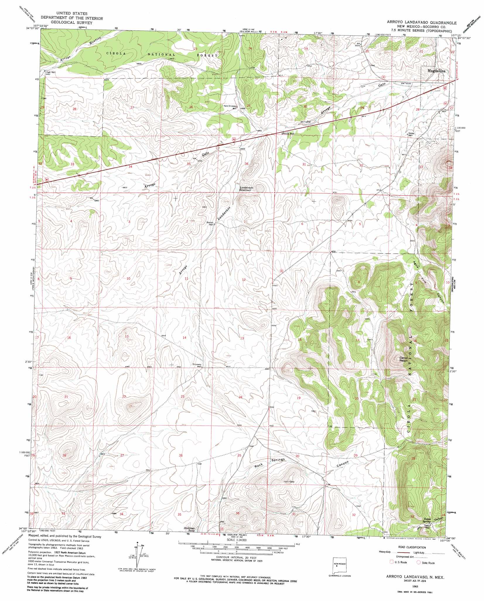
USGS Topo Quad 34107a3 - 1:24,000 scale
| Topo Map Name: | Arroyo Landavaso |
| USGS Topo Quad ID: | 34107a3 |
| Print Size: | ca. 21 1/4" wide x 27" high |
| Southeast Coordinates: | 34° N latitude / 107.25° W longitude |
| Map Center Coordinates: | 34.0625° N latitude / 107.3125° W longitude |
| U.S. State: | NM |
| Filename: | o34107a3.jpg |
| Download Map JPG Image: | Arroyo Landavaso topo map 1:24,000 scale |
| Map Type: | Topographic |
| Topo Series: | 7.5´ |
| Map Scale: | 1:24,000 |
| Source of Map Images: | United States Geological Survey (USGS) |
| Alternate Map Versions: |
Arroyo Landavaso NM 1963, updated 1967 Download PDF Buy paper map Arroyo Landavaso NM 1963, updated 1967 Download PDF Buy paper map Arroyo Landavaso NM 1995, updated 1998 Download PDF Buy paper map Arroyo Landavaso NM 2011 Download PDF Buy paper map Arroyo Landavaso NM 2013 Download PDF Buy paper map Arroyo Landavaso NM 2017 Download PDF Buy paper map |
| FStopo: | US Forest Service topo Arroyo Landavaso is available: Download FStopo PDF Download FStopo TIF |
1:24,000 Topo Quads surrounding Arroyo Landavaso
Indian Mesa |
Indian Spring Canyon |
Mesa Cencerro |
Carbon Springs |
Silver Creek |
Lion Mountain |
Gallinas Peak |
Silver Hill |
Granite Mountain |
San Lorenzo Spring |
Arrowhead Well |
Tres Montosas |
Arroyo Landavaso |
Magdalena |
Water Canyon |
Monica Saddle |
Mount Withington |
Squaw Peak |
South Baldy |
Molino Peak |
Bay Buck Peaks |
Grassy Lookout |
Tenmile Hill |
Puertecito Gap |
Cienega Ranch |
> Back to 34107a1 at 1:100,000 scale
> Back to 34106a1 at 1:250,000 scale
> Back to U.S. Topo Maps home
Arroyo Landavaso topo map: Gazetteer
Arroyo Landavaso: Airports
Magdalena Airport elevation 2038m 6686′Arroyo Landavaso: Arroyos
Arroyo Landavaso elevation 2029m 6656′Arroyo Landavaso: Reservoirs
Earth Tank Number One elevation 2172m 7125′Earth Tank Number Two elevation 2188m 7178′
Easy Tank elevation 2160m 7086′
Hale Tank elevation 2048m 6719′
Landavaso Reservoir elevation 2044m 6706′
North Tank elevation 2121m 6958′
Number Five Tank elevation 2120m 6955′
Number Four Tank elevation 2141m 7024′
Number One Tank elevation 2219m 7280′
Number Three Tank elevation 2241m 7352′
Number Two Tank elevation 2183m 7162′
Palome Tank elevation 2207m 7240′
SW Hale Tank elevation 2092m 6863′
Arroyo Landavaso: Springs
Texas Spring elevation 2307m 7568′Wet Weather Spring elevation 2284m 7493′
Arroyo Landavaso: Summits
Cerro Pelon elevation 2381m 7811′Arroyo Landavaso: Valleys
Agua Frio Canyon elevation 2104m 6902′Arroyo Landavaso: Wells
Boxcar Well elevation 2051m 6729′Deer Water Well elevation 2097m 6879′
Driveway Well elevation 2100m 6889′
Gosey Well elevation 2019m 6624′
Hale Driveway Well elevation 2039m 6689′
High Well elevation 2123m 6965′
Rabbe Well elevation 2026m 6646′
RG 30788 Water Well elevation 2128m 6981′
Texas Well elevation 2307m 7568′
Arroyo Landavaso digital topo map on disk
Buy this Arroyo Landavaso topo map showing relief, roads, GPS coordinates and other geographical features, as a high-resolution digital map file on DVD: