Mesa Cencerro Topo Map New Mexico
To zoom in, hover over the map of Mesa Cencerro
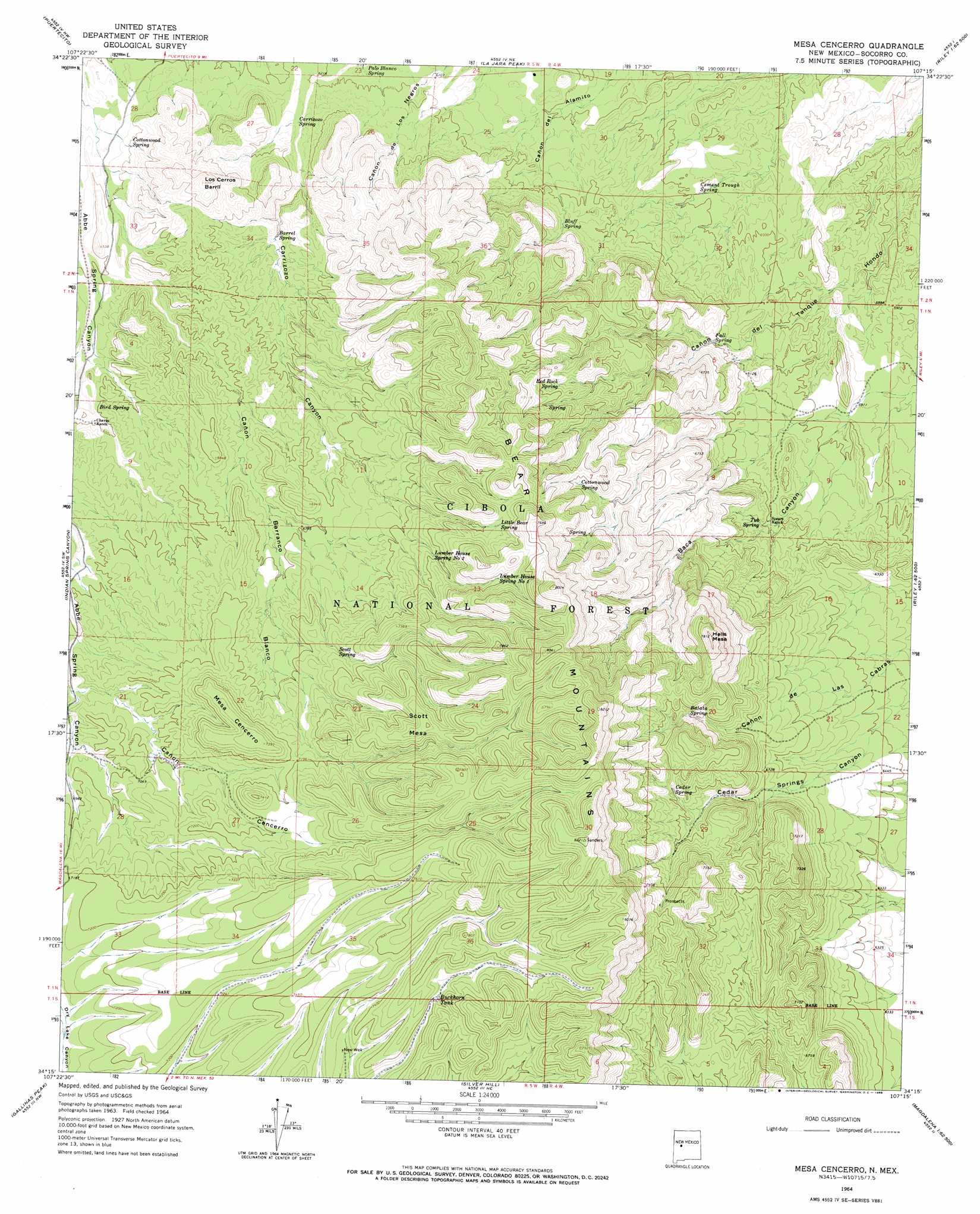
USGS Topo Quad 34107c3 - 1:24,000 scale
| Topo Map Name: | Mesa Cencerro |
| USGS Topo Quad ID: | 34107c3 |
| Print Size: | ca. 21 1/4" wide x 27" high |
| Southeast Coordinates: | 34.25° N latitude / 107.25° W longitude |
| Map Center Coordinates: | 34.3125° N latitude / 107.3125° W longitude |
| U.S. State: | NM |
| Filename: | o34107c3.jpg |
| Download Map JPG Image: | Mesa Cencerro topo map 1:24,000 scale |
| Map Type: | Topographic |
| Topo Series: | 7.5´ |
| Map Scale: | 1:24,000 |
| Source of Map Images: | United States Geological Survey (USGS) |
| Alternate Map Versions: |
Mesa Cencerro NM 1964, updated 1968 Download PDF Buy paper map Mesa Cencerro NM 1989, updated 1989 Download PDF Buy paper map Mesa Cencerro NM 1995, updated 1998 Download PDF Buy paper map Mesa Cencerro NM 2011 Download PDF Buy paper map Mesa Cencerro NM 2013 Download PDF Buy paper map Mesa Cencerro NM 2017 Download PDF Buy paper map |
| FStopo: | US Forest Service topo Mesa Cencerro is available: Download FStopo PDF Download FStopo TIF |
1:24,000 Topo Quads surrounding Mesa Cencerro
Pueblo Viejo Mesa |
Field Ranch |
Puerto De Los Cavadores |
Mesa Sarca |
Comanche Ranch |
Table Mountain |
Puertecito |
La Jara Peak |
Riley |
Ladron Peak |
Indian Mesa |
Indian Spring Canyon |
Mesa Cencerro |
Carbon Springs |
Silver Creek |
Lion Mountain |
Gallinas Peak |
Silver Hill |
Granite Mountain |
San Lorenzo Spring |
Arrowhead Well |
Tres Montosas |
Arroyo Landavaso |
Magdalena |
Water Canyon |
> Back to 34107a1 at 1:100,000 scale
> Back to 34106a1 at 1:250,000 scale
> Back to U.S. Topo Maps home
Mesa Cencerro topo map: Gazetteer
Mesa Cencerro: Reservoirs
Buckhorn Tank elevation 2261m 7417′New Tank elevation 2132m 6994′
Mesa Cencerro: Ridges
Bear Mountains elevation 2502m 8208′Mesa Cencerro: Springs
Baca Spring elevation 1896m 6220′Balata Spring elevation 2152m 7060′
Barrel Spring elevation 1963m 6440′
Bird Spring elevation 2015m 6610′
Bluff Spring elevation 1918m 6292′
Carrizozo Spring elevation 1907m 6256′
Cedar Spring elevation 2132m 6994′
Cement Trough Spring elevation 1816m 5958′
Cottonwood Spring elevation 2113m 6932′
Cottonwood Spring elevation 1953m 6407′
Deer Spring elevation 2197m 7208′
Dugout Spring elevation 2110m 6922′
Fall Spring elevation 1874m 6148′
Fenceline Spring elevation 2072m 6797′
Grapevine Spring elevation 2073m 6801′
Hidden Spring elevation 1891m 6204′
Little Bear Spring elevation 2221m 7286′
Lumber House Spring Number One elevation 2247m 7372′
Lumber House Spring Number Two elevation 2175m 7135′
Palo Blanco Spring elevation 1878m 6161′
Red Rock Spring elevation 2032m 6666′
Red Rock Spring elevation 1946m 6384′
Scott Spring elevation 2158m 7080′
Tub Spring elevation 1891m 6204′
Winter Spring elevation 2142m 7027′
Mesa Cencerro: Summits
Hells Mesa elevation 2366m 7762′Los Cerros Barril elevation 2122m 6961′
Mesa Cencerro elevation 2249m 7378′
Scott Mesa elevation 2319m 7608′
Mesa Cencerro: Valleys
Cañon Barranco Blanco elevation 1943m 6374′Canon Casa de Madera elevation 2049m 6722′
Scott Spring Canyon elevation 2081m 6827′
Mesa Cencerro: Wells
New Well elevation 2224m 7296′Mesa Cencerro digital topo map on disk
Buy this Mesa Cencerro topo map showing relief, roads, GPS coordinates and other geographical features, as a high-resolution digital map file on DVD: