Indian Mesa Topo Map New Mexico
To zoom in, hover over the map of Indian Mesa
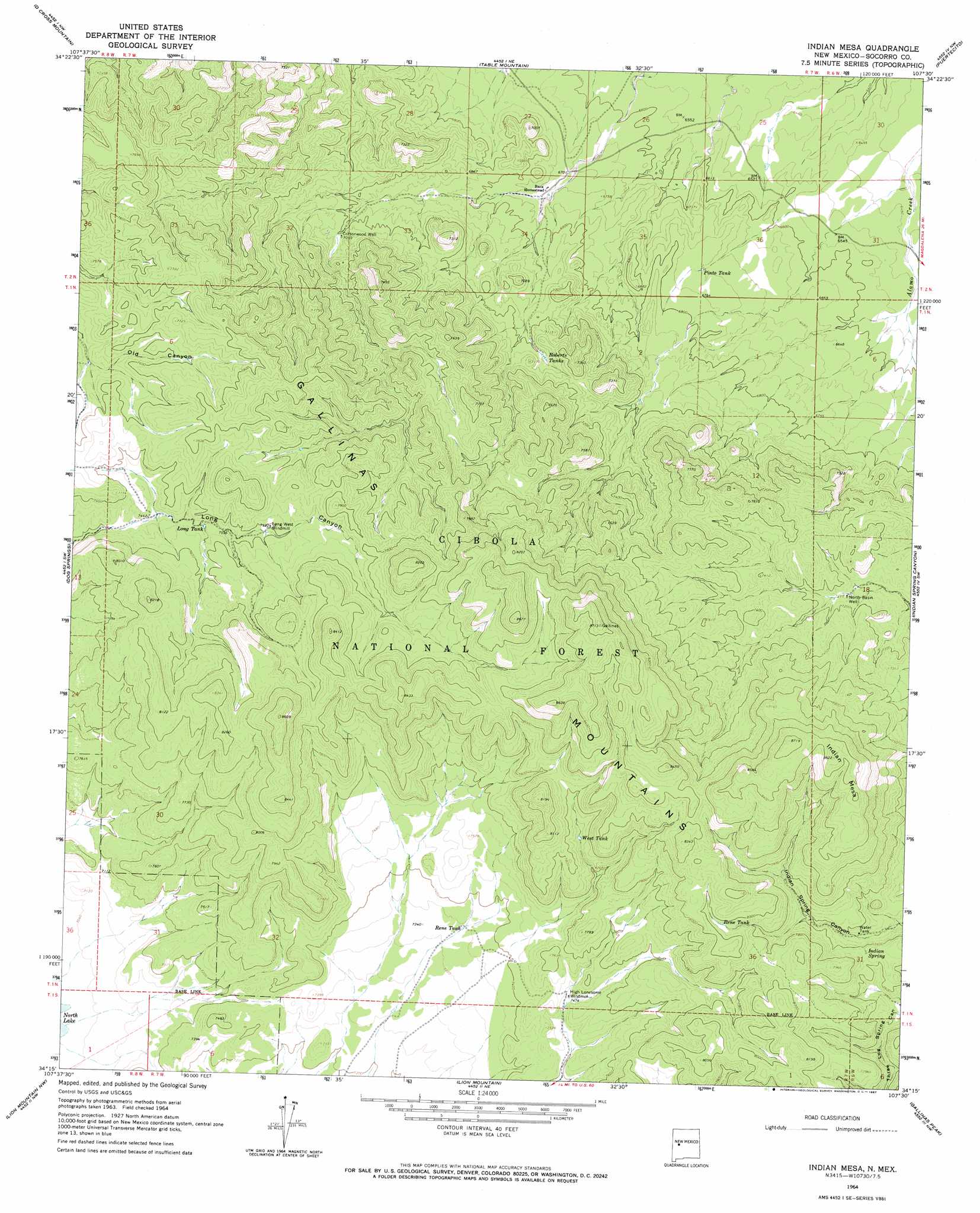
USGS Topo Quad 34107c5 - 1:24,000 scale
| Topo Map Name: | Indian Mesa |
| USGS Topo Quad ID: | 34107c5 |
| Print Size: | ca. 21 1/4" wide x 27" high |
| Southeast Coordinates: | 34.25° N latitude / 107.5° W longitude |
| Map Center Coordinates: | 34.3125° N latitude / 107.5625° W longitude |
| U.S. State: | NM |
| Filename: | o34107c5.jpg |
| Download Map JPG Image: | Indian Mesa topo map 1:24,000 scale |
| Map Type: | Topographic |
| Topo Series: | 7.5´ |
| Map Scale: | 1:24,000 |
| Source of Map Images: | United States Geological Survey (USGS) |
| Alternate Map Versions: |
Indian Mesa NM 1964, updated 1967 Download PDF Buy paper map Indian Mesa NM 1995, updated 1998 Download PDF Buy paper map Indian Mesa NM 2011 Download PDF Buy paper map Indian Mesa NM 2013 Download PDF Buy paper map Indian Mesa NM 2017 Download PDF Buy paper map |
| FStopo: | US Forest Service topo Indian Mesa is available: Download FStopo PDF Download FStopo TIF |
1:24,000 Topo Quads surrounding Indian Mesa
Wild Horse Canyon |
Wiley Mesa |
Pueblo Viejo Mesa |
Field Ranch |
Puerto De Los Cavadores |
Pasture Canyon |
D Cross Mountain |
Table Mountain |
Puertecito |
La Jara Peak |
Cal Ship Mesa |
Dog Springs |
Indian Mesa |
Indian Spring Canyon |
Mesa Cencerro |
Datil |
Lion Mountain Nw |
Lion Mountain |
Gallinas Peak |
Silver Hill |
Anderson Peak |
Augustine Well |
Arrowhead Well |
Tres Montosas |
Arroyo Landavaso |
> Back to 34107a1 at 1:100,000 scale
> Back to 34106a1 at 1:250,000 scale
> Back to U.S. Topo Maps home
Indian Mesa topo map: Gazetteer
Indian Mesa: Forests
Cibola National Forest elevation 2348m 7703′Indian Mesa: Reservoirs
Long Tank elevation 2290m 7513′Pinto Tank elevation 2050m 6725′
Rene Tank elevation 2423m 7949′
Rene Tank elevation 2239m 7345′
Roberts Tanks elevation 2153m 7063′
West Tank elevation 2344m 7690′
Indian Mesa: Springs
Indian Spring elevation 2337m 7667′Indian Mesa: Summits
Indian Mesa elevation 2600m 8530′Indian Mesa: Wells
Baca Homes Water Well elevation 2056m 6745′Baca Homestead Water Well elevation 2050m 6725′
Cottonwood Well elevation 2159m 7083′
North Basin Well elevation 2170m 7119′
Indian Mesa digital topo map on disk
Buy this Indian Mesa topo map showing relief, roads, GPS coordinates and other geographical features, as a high-resolution digital map file on DVD: