La Jara Peak Topo Map New Mexico
To zoom in, hover over the map of La Jara Peak
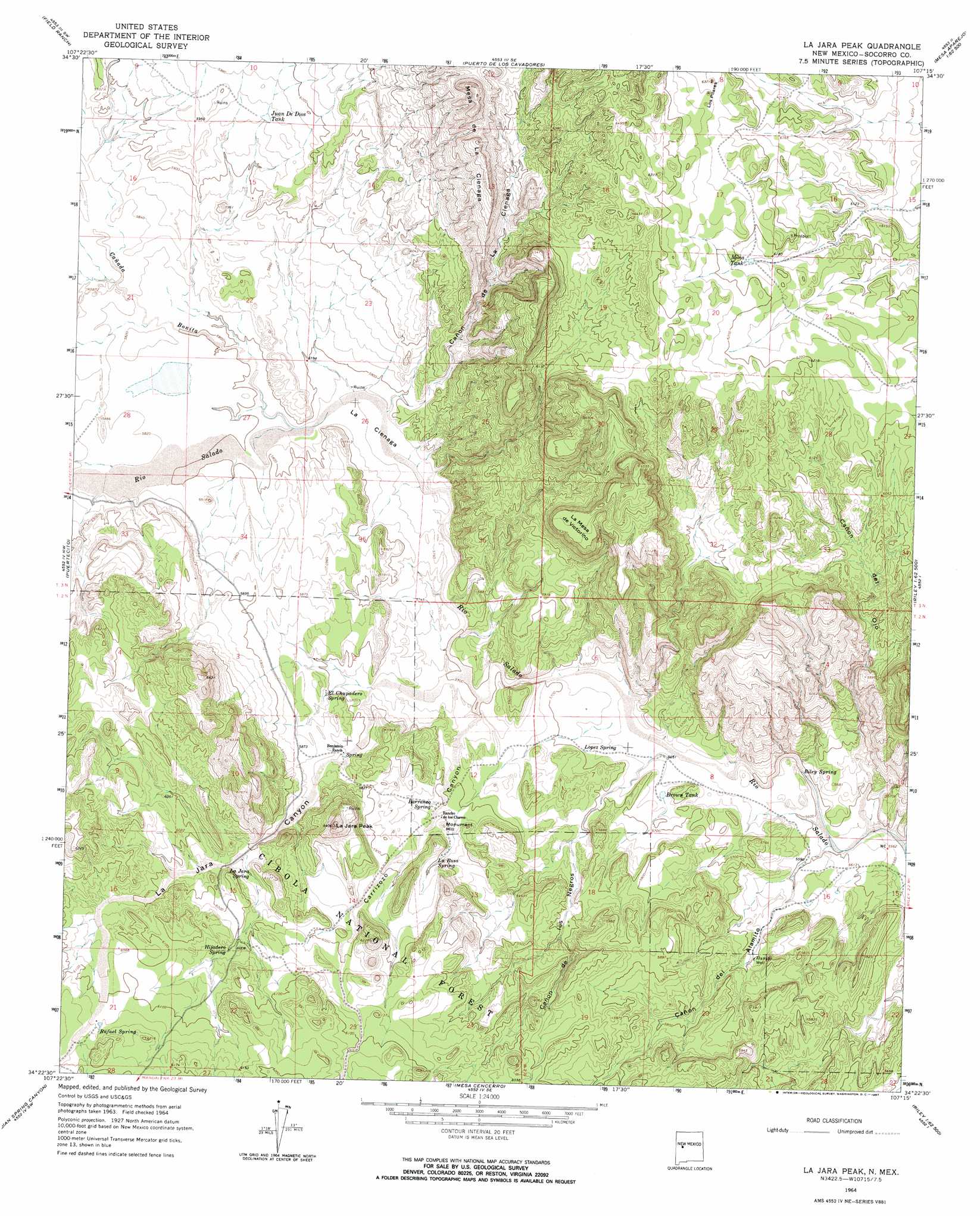
USGS Topo Quad 34107d3 - 1:24,000 scale
| Topo Map Name: | La Jara Peak |
| USGS Topo Quad ID: | 34107d3 |
| Print Size: | ca. 21 1/4" wide x 27" high |
| Southeast Coordinates: | 34.375° N latitude / 107.25° W longitude |
| Map Center Coordinates: | 34.4375° N latitude / 107.3125° W longitude |
| U.S. State: | NM |
| Filename: | o34107d3.jpg |
| Download Map JPG Image: | La Jara Peak topo map 1:24,000 scale |
| Map Type: | Topographic |
| Topo Series: | 7.5´ |
| Map Scale: | 1:24,000 |
| Source of Map Images: | United States Geological Survey (USGS) |
| Alternate Map Versions: |
La Jara Peak NM 1964, updated 1967 Download PDF Buy paper map La Jara Peak NM 1995, updated 1998 Download PDF Buy paper map La Jara Peak NM 2011 Download PDF Buy paper map La Jara Peak NM 2013 Download PDF Buy paper map La Jara Peak NM 2017 Download PDF Buy paper map |
| FStopo: | US Forest Service topo La Jara Peak is available: Download FStopo PDF Download FStopo TIF |
1:24,000 Topo Quads surrounding La Jara Peak
Broom Mountain |
Cerro Del Oro |
Chicken Mountain |
Mesa Gallina |
Mesas Mojinas |
Pueblo Viejo Mesa |
Field Ranch |
Puerto De Los Cavadores |
Mesa Sarca |
Comanche Ranch |
Table Mountain |
Puertecito |
La Jara Peak |
Riley |
Ladron Peak |
Indian Mesa |
Indian Spring Canyon |
Mesa Cencerro |
Carbon Springs |
Silver Creek |
Lion Mountain |
Gallinas Peak |
Silver Hill |
Granite Mountain |
San Lorenzo Spring |
> Back to 34107a1 at 1:100,000 scale
> Back to 34106a1 at 1:250,000 scale
> Back to U.S. Topo Maps home
La Jara Peak topo map: Gazetteer
La Jara Peak: Arroyos
Cañada Bonita elevation 1762m 5780′La Jara Peak: Benches
La Mesa de Victorino elevation 1933m 6341′La Jara Peak: Flats
La Cienaga elevation 1756m 5761′La Jara Peak: Mines
Helen elevation 1789m 5869′Katherine elevation 1774m 5820′
Romero elevation 1851m 6072′
La Jara Peak: Pillars
Los Pilares elevation 1909m 6263′La Jara Peak: Reservoirs
Brown Tank elevation 1729m 5672′Bull Tank elevation 1844m 6049′
Juan De Dios Tank elevation 1814m 5951′
Mina Tank elevation 1880m 6167′
La Jara Peak: Springs
Barranco Spring elevation 1773m 5816′El Chupadero Spring elevation 1775m 5823′
Hijadero Spring elevation 1832m 6010′
La Jara Spring elevation 1805m 5921′
La Rosa Spring elevation 1800m 5905′
Lopez Spring elevation 1738m 5702′
Rafael Spring elevation 1871m 6138′
Riley Spring elevation 1705m 5593′
La Jara Peak: Summits
La Jara Peak elevation 1914m 6279′Monument Hill elevation 1798m 5898′
La Jara Peak: Valleys
Cañon de la Cienaga elevation 1754m 5754′Cañon de los Negros elevation 1720m 5643′
Cañon de Ojo elevation 1697m 5567′
Cañon del Alamito elevation 1700m 5577′
Carrizozo Canyon elevation 1737m 5698′
La Jara Canyon elevation 1738m 5702′
La Jara Peak: Wells
Alamito Well elevation 1741m 5711′La Jara Peak digital topo map on disk
Buy this La Jara Peak topo map showing relief, roads, GPS coordinates and other geographical features, as a high-resolution digital map file on DVD: