Comanche Ranch Topo Map New Mexico
To zoom in, hover over the map of Comanche Ranch
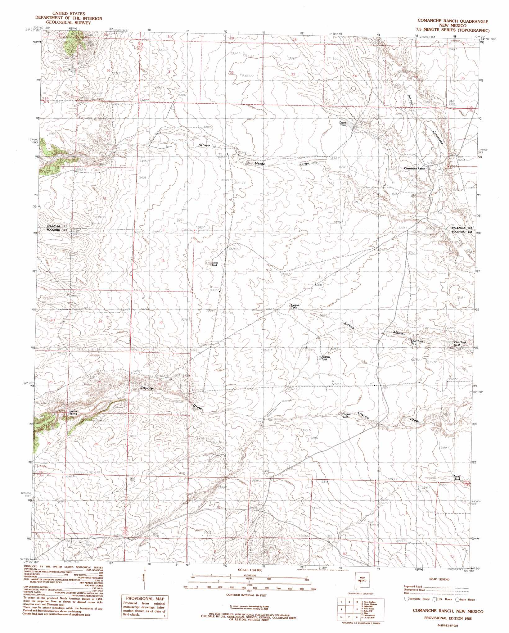
USGS Topo Quad 34107e1 - 1:24,000 scale
| Topo Map Name: | Comanche Ranch |
| USGS Topo Quad ID: | 34107e1 |
| Print Size: | ca. 21 1/4" wide x 27" high |
| Southeast Coordinates: | 34.5° N latitude / 107° W longitude |
| Map Center Coordinates: | 34.5625° N latitude / 107.0625° W longitude |
| U.S. State: | NM |
| Filename: | o34107e1.jpg |
| Download Map JPG Image: | Comanche Ranch topo map 1:24,000 scale |
| Map Type: | Topographic |
| Topo Series: | 7.5´ |
| Map Scale: | 1:24,000 |
| Source of Map Images: | United States Geological Survey (USGS) |
| Alternate Map Versions: |
Comanche Ranch NM 1985, updated 1985 Download PDF Buy paper map Comanche Ranch NM 2010 Download PDF Buy paper map Comanche Ranch NM 2013 Download PDF Buy paper map Comanche Ranch NM 2017 Download PDF Buy paper map |
1:24,000 Topo Quads surrounding Comanche Ranch
Cerro Verde |
White Ridge |
South Garcia Se |
Rio Puerco |
Dalies |
Chicken Mountain |
Mesa Gallina |
Mesas Mojinas |
Belen Nw |
Belen |
Puerto De Los Cavadores |
Mesa Sarca |
Comanche Ranch |
Belen Sw |
Veguita |
La Jara Peak |
Riley |
Ladron Peak |
La Joya Nw |
Abeytas |
Mesa Cencerro |
Carbon Springs |
Silver Creek |
San Acacia |
La Joya |
> Back to 34107e1 at 1:100,000 scale
> Back to 34106a1 at 1:250,000 scale
> Back to U.S. Topo Maps home
Comanche Ranch topo map: Gazetteer
Comanche Ranch: Dams
Indio Loco Detention Dam elevation 1689m 5541′Loco Retention Dam elevation 1578m 5177′
Comanche Ranch: Reservoirs
Andrew Tank elevation 1606m 5269′Bryce Tank elevation 1625m 5331′
Clequa Tank elevation 1607m 5272′
Click Tank Number 2 elevation 1575m 5167′
Click Tank Number 7 elevation 1583m 5193′
Coyote Tank elevation 1601m 5252′
Diego Tank elevation 1613m 5291′
East Tank elevation 1693m 5554′
Heredura Tank elevation 1613m 5291′
Lost Spring Tank elevation 1571m 5154′
Middle Tank elevation 1628m 5341′
Monte Largo Tank elevation 1651m 5416′
Tacho Tank elevation 1576m 5170′
Comanche Ranch: Springs
Coyote Spring elevation 1664m 5459′Comanche Ranch: Streams
Arroyo Monte Largo elevation 1583m 5193′Arroyo Pato elevation 1677m 5501′
Comanche Ranch digital topo map on disk
Buy this Comanche Ranch topo map showing relief, roads, GPS coordinates and other geographical features, as a high-resolution digital map file on DVD: