Puerto De Los Cavadores Topo Map New Mexico
To zoom in, hover over the map of Puerto De Los Cavadores
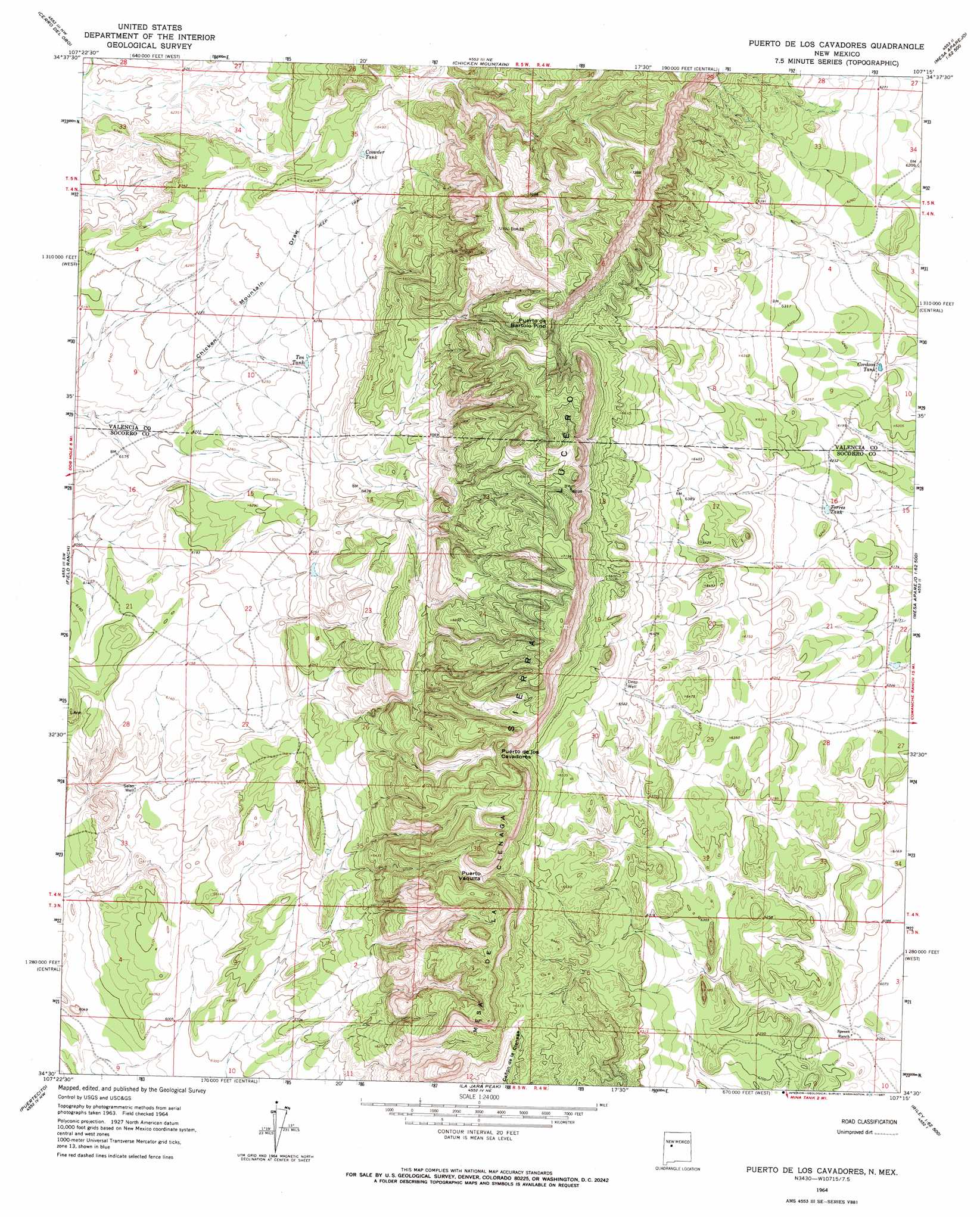
USGS Topo Quad 34107e3 - 1:24,000 scale
| Topo Map Name: | Puerto De Los Cavadores |
| USGS Topo Quad ID: | 34107e3 |
| Print Size: | ca. 21 1/4" wide x 27" high |
| Southeast Coordinates: | 34.5° N latitude / 107.25° W longitude |
| Map Center Coordinates: | 34.5625° N latitude / 107.3125° W longitude |
| U.S. State: | NM |
| Filename: | o34107e3.jpg |
| Download Map JPG Image: | Puerto De Los Cavadores topo map 1:24,000 scale |
| Map Type: | Topographic |
| Topo Series: | 7.5´ |
| Map Scale: | 1:24,000 |
| Source of Map Images: | United States Geological Survey (USGS) |
| Alternate Map Versions: |
Puerto De Los Cavadores NM 1964, updated 1967 Download PDF Buy paper map Puerto De Los Cavadores NM 2010 Download PDF Buy paper map Puerto De Los Cavadores NM 2013 Download PDF Buy paper map Puerto De Los Cavadores NM 2017 Download PDF Buy paper map |
1:24,000 Topo Quads surrounding Puerto De Los Cavadores
East Mesa |
Marmon Ranch |
Cerro Verde |
White Ridge |
South Garcia Se |
Broom Mountain |
Cerro Del Oro |
Chicken Mountain |
Mesa Gallina |
Mesas Mojinas |
Pueblo Viejo Mesa |
Field Ranch |
Puerto De Los Cavadores |
Mesa Sarca |
Comanche Ranch |
Table Mountain |
Puertecito |
La Jara Peak |
Riley |
Ladron Peak |
Indian Mesa |
Indian Spring Canyon |
Mesa Cencerro |
Carbon Springs |
Silver Creek |
> Back to 34107e1 at 1:100,000 scale
> Back to 34106a1 at 1:250,000 scale
> Back to U.S. Topo Maps home
Puerto De Los Cavadores topo map: Gazetteer
Puerto De Los Cavadores: Gaps
Puerto de Bartolo Pino elevation 2138m 7014′Puerto de los Cavadores elevation 2078m 6817′
Puerto Vaquita elevation 2043m 6702′
Puerto De Los Cavadores: Reservoirs
Cordova Tank elevation 1889m 6197′Crowder Tank elevation 1960m 6430′
Ten Tank elevation 1913m 6276′
Torres Tank elevation 1891m 6204′
Puerto De Los Cavadores: Summits
Mesa de la Cienaga elevation 2107m 6912′Puerto De Los Cavadores: Wells
Deep Well elevation 1989m 6525′Selso Well elevation 1851m 6072′
Puerto De Los Cavadores digital topo map on disk
Buy this Puerto De Los Cavadores topo map showing relief, roads, GPS coordinates and other geographical features, as a high-resolution digital map file on DVD: