Field Ranch Topo Map New Mexico
To zoom in, hover over the map of Field Ranch
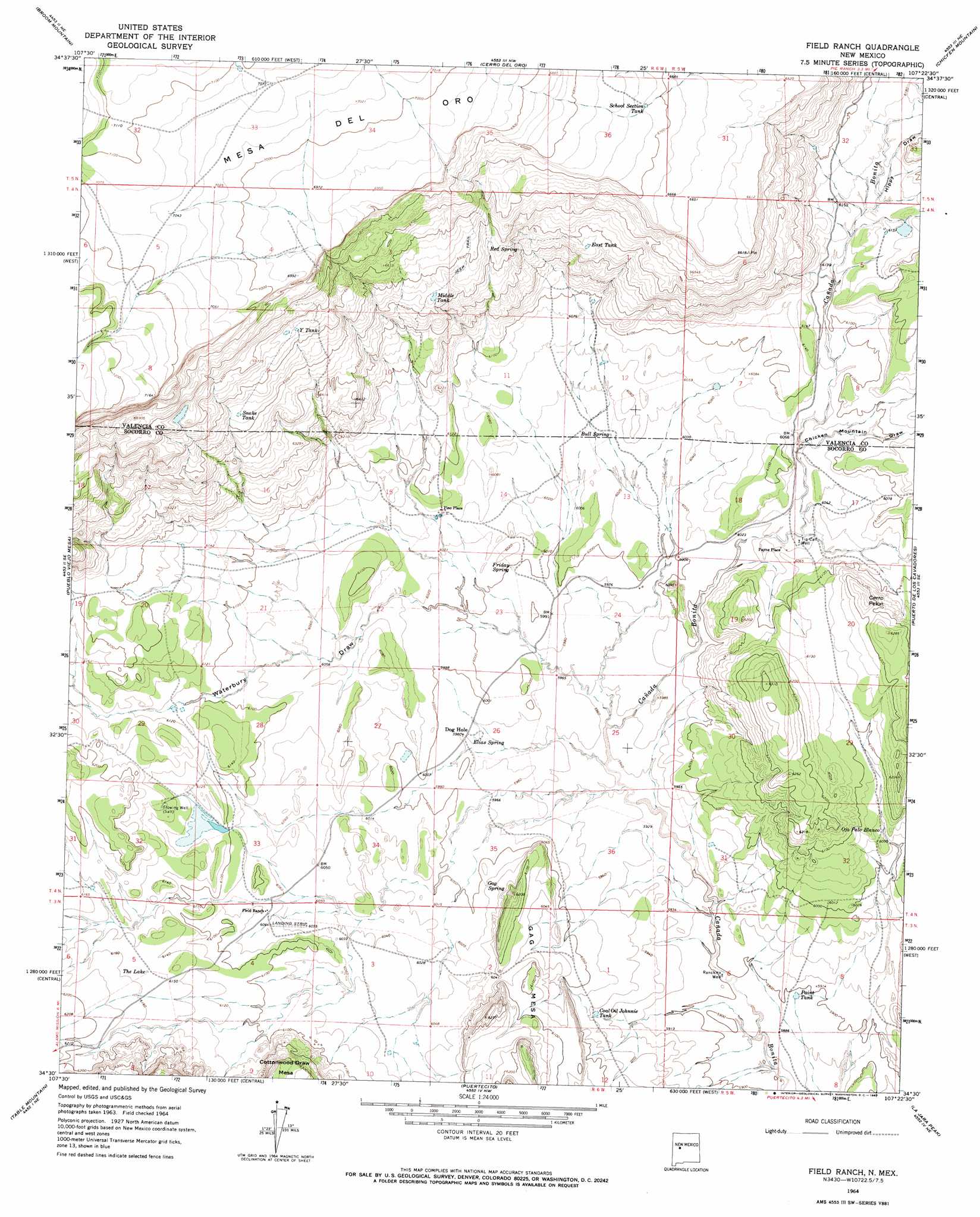
USGS Topo Quad 34107e4 - 1:24,000 scale
| Topo Map Name: | Field Ranch |
| USGS Topo Quad ID: | 34107e4 |
| Print Size: | ca. 21 1/4" wide x 27" high |
| Southeast Coordinates: | 34.5° N latitude / 107.375° W longitude |
| Map Center Coordinates: | 34.5625° N latitude / 107.4375° W longitude |
| U.S. State: | NM |
| Filename: | o34107e4.jpg |
| Download Map JPG Image: | Field Ranch topo map 1:24,000 scale |
| Map Type: | Topographic |
| Topo Series: | 7.5´ |
| Map Scale: | 1:24,000 |
| Source of Map Images: | United States Geological Survey (USGS) |
| Alternate Map Versions: |
Field Ranch NM 1964, updated 1967 Download PDF Buy paper map Field Ranch NM 2010 Download PDF Buy paper map Field Ranch NM 2013 Download PDF Buy paper map Field Ranch NM 2017 Download PDF Buy paper map |
1:24,000 Topo Quads surrounding Field Ranch
Blue Mesa |
East Mesa |
Marmon Ranch |
Cerro Verde |
White Ridge |
Mecate Meadow |
Broom Mountain |
Cerro Del Oro |
Chicken Mountain |
Mesa Gallina |
Wiley Mesa |
Pueblo Viejo Mesa |
Field Ranch |
Puerto De Los Cavadores |
Mesa Sarca |
D Cross Mountain |
Table Mountain |
Puertecito |
La Jara Peak |
Riley |
Dog Springs |
Indian Mesa |
Indian Spring Canyon |
Mesa Cencerro |
Carbon Springs |
> Back to 34107e1 at 1:100,000 scale
> Back to 34106a1 at 1:250,000 scale
> Back to U.S. Topo Maps home
Field Ranch topo map: Gazetteer
Field Ranch: Lakes
The Lake elevation 1877m 6158′Field Ranch: Populated Places
Payne Place elevation 1844m 6049′Pino Place elevation 1846m 6056′
Field Ranch: Reservoirs
Coal Oil Johnnie Tank elevation 1816m 5958′East Tank elevation 1941m 6368′
Middle Tank elevation 1965m 6446′
Paint Tank elevation 1798m 5898′
School Section Tank elevation 2048m 6719′
Snake Tank elevation 1991m 6532′
Y Tank elevation 2026m 6646′
Field Ranch: Springs
Bull Spring elevation 1840m 6036′Elias Spring elevation 1824m 5984′
Friday Spring elevation 1829m 6000′
Gag Spring elevation 1835m 6020′
Ojo Palo Blanco elevation 1835m 6020′
Red Spring elevation 1928m 6325′
Field Ranch: Summits
Cerro Pelon elevation 1911m 6269′Gag Mesa elevation 1910m 6266′
Field Ranch: Valleys
Chicken Mountain Draw elevation 1842m 6043′Hippy Draw elevation 1872m 6141′
Waterbury Draw elevation 1811m 5941′
Field Ranch: Wells
Dog Hole Water Well elevation 1824m 5984′Flowing Water Well elevation 1879m 6164′
Ranchito Well elevation 1799m 5902′
Tin Can Water Well elevation 1839m 6033′
Tin Can Well elevation 1839m 6033′
Field Ranch digital topo map on disk
Buy this Field Ranch topo map showing relief, roads, GPS coordinates and other geographical features, as a high-resolution digital map file on DVD: