Chicken Mountain Topo Map New Mexico
To zoom in, hover over the map of Chicken Mountain
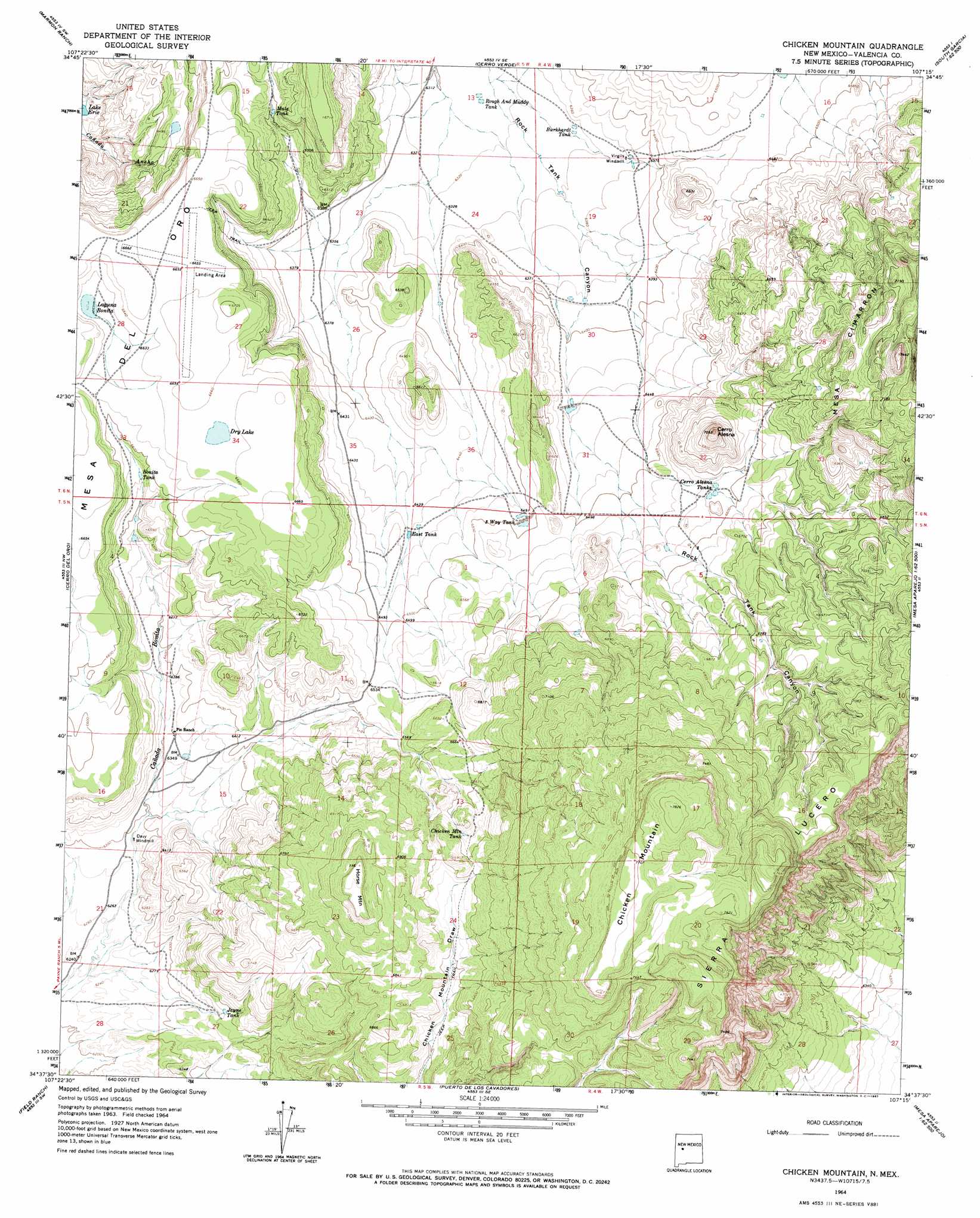
USGS Topo Quad 34107f3 - 1:24,000 scale
| Topo Map Name: | Chicken Mountain |
| USGS Topo Quad ID: | 34107f3 |
| Print Size: | ca. 21 1/4" wide x 27" high |
| Southeast Coordinates: | 34.625° N latitude / 107.25° W longitude |
| Map Center Coordinates: | 34.6875° N latitude / 107.3125° W longitude |
| U.S. State: | NM |
| Filename: | o34107f3.jpg |
| Download Map JPG Image: | Chicken Mountain topo map 1:24,000 scale |
| Map Type: | Topographic |
| Topo Series: | 7.5´ |
| Map Scale: | 1:24,000 |
| Source of Map Images: | United States Geological Survey (USGS) |
| Alternate Map Versions: |
Chicken Mountain NM 1964, updated 1967 Download PDF Buy paper map Chicken Mountain NM 2010 Download PDF Buy paper map Chicken Mountain NM 2013 Download PDF Buy paper map Chicken Mountain NM 2017 Download PDF Buy paper map |
1:24,000 Topo Quads surrounding Chicken Mountain
Acoma Pueblo |
South Butte |
Dough Mountain |
Correo |
South Garcia |
East Mesa |
Marmon Ranch |
Cerro Verde |
White Ridge |
South Garcia Se |
Broom Mountain |
Cerro Del Oro |
Chicken Mountain |
Mesa Gallina |
Mesas Mojinas |
Pueblo Viejo Mesa |
Field Ranch |
Puerto De Los Cavadores |
Mesa Sarca |
Comanche Ranch |
Table Mountain |
Puertecito |
La Jara Peak |
Riley |
Ladron Peak |
> Back to 34107e1 at 1:100,000 scale
> Back to 34106a1 at 1:250,000 scale
> Back to U.S. Topo Maps home
Chicken Mountain topo map: Gazetteer
Chicken Mountain: Dams
Pronto Detention Dam elevation 1978m 6489′T X Detention Dike Number 1 elevation 1946m 6384′
T X Diversion Dam Number Three elevation 1964m 6443′
Chicken Mountain: Lakes
Dry Lake elevation 2029m 6656′Laguna Bonita elevation 2014m 6607′
Chicken Mountain: Reservoirs
Bonita Tank elevation 1996m 6548′Burkhardt Tank elevation 1932m 6338′
Cerro Alesna Tanks elevation 2008m 6587′
Chicken Mountain Tank elevation 2058m 6751′
East Tank elevation 1965m 6446′
Jayne Tank elevation 1947m 6387′
Mule Tank elevation 1980m 6496′
Rough and Muddy Tank elevation 1924m 6312′
Three Way Tank elevation 1982m 6502′
Chicken Mountain: Ridges
Sierra Lucero elevation 2343m 7687′Chicken Mountain: Summits
Cerro Alesna elevation 2143m 7030′Chicken Mountain elevation 2319m 7608′
Horse Mountain elevation 2181m 7155′
Mesa Cimarron elevation 2264m 7427′
Chicken Mountain: Wells
Davy Water Well elevation 1915m 6282′Pie Ranch Water Well elevation 1941m 6368′
Chicken Mountain digital topo map on disk
Buy this Chicken Mountain topo map showing relief, roads, GPS coordinates and other geographical features, as a high-resolution digital map file on DVD: