Wallace Mesa Topo Map New Mexico
To zoom in, hover over the map of Wallace Mesa
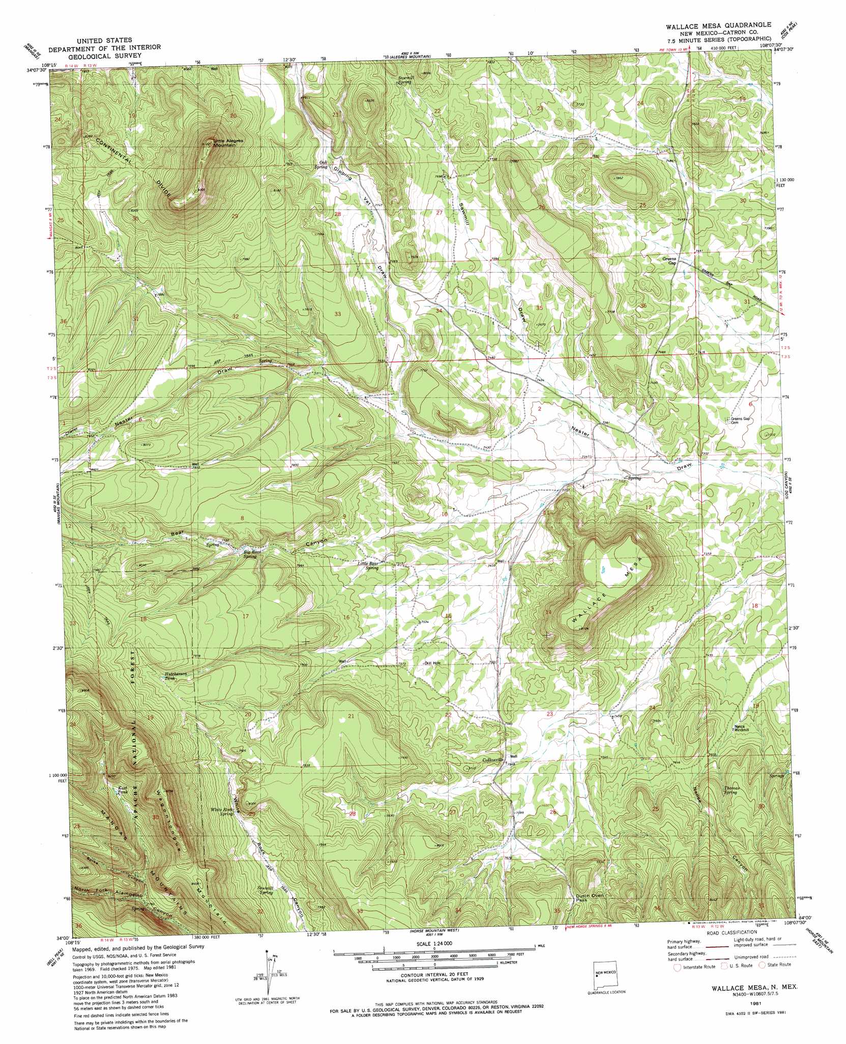
USGS Topo Quad 34108a2 - 1:24,000 scale
| Topo Map Name: | Wallace Mesa |
| USGS Topo Quad ID: | 34108a2 |
| Print Size: | ca. 21 1/4" wide x 27" high |
| Southeast Coordinates: | 34° N latitude / 108.125° W longitude |
| Map Center Coordinates: | 34.0625° N latitude / 108.1875° W longitude |
| U.S. State: | NM |
| Filename: | o34108a2.jpg |
| Download Map JPG Image: | Wallace Mesa topo map 1:24,000 scale |
| Map Type: | Topographic |
| Topo Series: | 7.5´ |
| Map Scale: | 1:24,000 |
| Source of Map Images: | United States Geological Survey (USGS) |
| Alternate Map Versions: |
Wallace Mesa NM 1981, updated 1981 Download PDF Buy paper map Wallace Mesa NM 1999, updated 2002 Download PDF Buy paper map Wallace Mesa NM 2011 Download PDF Buy paper map Wallace Mesa NM 2013 Download PDF Buy paper map Wallace Mesa NM 2017 Download PDF Buy paper map |
| FStopo: | US Forest Service topo Wallace Mesa is available: Download FStopo PDF Download FStopo TIF |
1:24,000 Topo Quads surrounding Wallace Mesa
Quemado |
Omega |
Pie Town |
Red Flats |
Madre Mountain |
Escondido Mountains |
Mangas |
Alegres Mountain |
Cox Peak |
Crosby Springs |
Slaughter Mesa |
Mangas Mountain |
Wallace Mesa |
Log Canyon |
Sugarloaf Mountain |
Tullarosa Canyon |
Bell Peak |
Horse Mountain West |
Horse Mountain East |
Luera Mountains Nw |
John Kerr Peak |
Rael Spring |
Fullerton |
Shaw Mountain |
Luera Mountains West |
> Back to 34108a1 at 1:100,000 scale
> Back to 34108a1 at 1:250,000 scale
> Back to U.S. Topo Maps home
Wallace Mesa topo map: Gazetteer
Wallace Mesa: Gaps
Dutch Oven Pass elevation 2374m 7788′Wallace Mesa: Populated Places
Greens Gap elevation 2271m 7450′Wallace Mesa: Post Offices
Greens Gap Post Office (historical) elevation 2345m 7693′Wallace Mesa: Reservoirs
East Tank elevation 2472m 8110′Hutcherson Tank elevation 2428m 7965′
Wallace Mesa: Springs
Big Bear Spring elevation 2342m 7683′Little Bear Spring elevation 2294m 7526′
Oak Spring elevation 2382m 7814′
Sawmill Spring elevation 2401m 7877′
Sawmill Spring elevation 2307m 7568′
Texas Spring elevation 2219m 7280′
Thomas Spring elevation 2340m 7677′
White Rock Spring elevation 2334m 7657′
Wallace Mesa: Summits
Little Alegres Mountain elevation 2779m 9117′Wagontongue Mountain elevation 2667m 8750′
Wallace Mesa elevation 2477m 8126′
Wallace Mesa: Valleys
Bear Canyon elevation 2223m 7293′Chavez Canyon elevation 2417m 7929′
Dipping Vat Draw elevation 2287m 7503′
Saw Mill Draw elevation 2218m 7276′
Spike Canyon elevation 2509m 8231′
Wallace Mesa digital topo map on disk
Buy this Wallace Mesa topo map showing relief, roads, GPS coordinates and other geographical features, as a high-resolution digital map file on DVD: