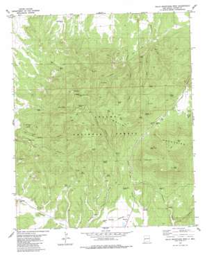
Gallo Mountains West Topo Map New Mexico
To zoom in, hover over the map of Gallo Mountains West
USGS Topo Quad 34108a6 - 1:24,000 scale
| Topo Map Name: | Gallo Mountains West |
| USGS Topo Quad ID: | 34108a6 |
| Print Size: | ca. 21 1/4" wide x 27" high |
| Southeast Coordinates: | 34° N latitude / 108.625° W longitude |
| Map Center Coordinates: | 34.0625° N latitude / 108.6875° W longitude |
| U.S. State: | NM |
| Filename: | o34108a6.jpg |
| Download Map JPG Image: | Gallo Mountains West topo map 1:24,000 scale |
| Map Type: | Topographic |
| Topo Series: | 7.5´ |
| Map Scale: | 1:24,000 |
| Source of Map Images: | United States Geological Survey (USGS) |
| Alternate Map Versions: |
Gallo Mountains West NM 1981, updated 1981 Download PDF Buy paper map Gallo Mountains West NM 1999, updated 2002 Download PDF Buy paper map Gallo Mountains West NM 2011 Download PDF Buy paper map Gallo Mountains West NM 2013 Download PDF Buy paper map Gallo Mountains West NM 2017 Download PDF Buy paper map |
| FStopo: | US Forest Service topo Gallo Mountains West is available: Download FStopo PDF Download FStopo TIF |
1:24,000 Topo Quads surrounding Gallo Mountains West
> Back to 34108a1 at 1:100,000 scale
> Back to 34108a1 at 1:250,000 scale
> Back to U.S. Topo Maps home
Gallo Mountains West topo map: Gazetteer
Gallo Mountains West: Airports
Jewett Mesa Airport elevation 2336m 7664′Gallo Mountains West: Flats
Elk Flat elevation 2715m 8907′Gallo Mountains West: Gaps
Jewett Gap elevation 2500m 8202′Gallo Mountains West: Reservoirs
Airstrip Tank elevation 2306m 7565′Corner Tank elevation 2563m 8408′
Elk Tank elevation 2703m 8868′
Fox Tank elevation 2552m 8372′
Gallo Peak Tank elevation 2642m 8667′
Gap Tank elevation 2481m 8139′
Grassy Tank elevation 2677m 8782′
Hardcastle Tank elevation 2308m 7572′
Headwater Tank elevation 2358m 7736′
Hidden Tank elevation 2660m 8727′
Mallet Tank elevation 2681m 8795′
Next Tank elevation 2330m 7644′
Oso Negro Tank elevation 2725m 8940′
Pit Tank elevation 2710m 8891′
Renfro Tank elevation 2385m 7824′
Road Canyon Tank elevation 2519m 8264′
Steel Tank elevation 2393m 7851′
Top Tank elevation 2714m 8904′
Willie Steel Tank elevation 2382m 7814′
Gallo Mountains West: Springs
Aspen Springs elevation 2540m 8333′Black Spring elevation 2406m 7893′
Brown Spring elevation 2489m 8166′
Brush Spring elevation 2420m 7939′
Cabin Spring elevation 2395m 7857′
Diaper Spring elevation 2515m 8251′
Elderberry Spring elevation 2678m 8786′
Fox Spring elevation 2534m 8313′
Headwaters Spring elevation 2306m 7565′
Lawson Spring elevation 2588m 8490′
Lost Spring elevation 2533m 8310′
Oak Spring elevation 2397m 7864′
Perry Canyon Spring elevation 2472m 8110′
Ruin Spring elevation 2361m 7746′
Turkey Roast Spring elevation 2336m 7664′
Turkey Roost Spring elevation 2342m 7683′
Valorie Spring elevation 2419m 7936′
Willie Steel Spring elevation 2432m 7979′
Gallo Mountains West: Streams
Demetrio Creek elevation 2305m 7562′Gallo Mountains West: Summits
Fox Mountain elevation 2782m 9127′Gallo Peak elevation 2818m 9245′
Jewett Mesa elevation 2335m 7660′
Gallo Mountains West: Valleys
Canon Blanco elevation 2330m 7644′Deep Canyon elevation 2468m 8097′
Gallo Canyon elevation 2276m 7467′
Gate Canyon elevation 2340m 7677′
Willie Steel Canyon elevation 2459m 8067′
Gallo Mountains West: Wells
Apache Well elevation 2467m 8093′Gallo Well elevation 2467m 8093′
Gallo Mountains West digital topo map on disk
Buy this Gallo Mountains West topo map showing relief, roads, GPS coordinates and other geographical features, as a high-resolution digital map file on DVD:


