Red Flats Topo Map New Mexico
To zoom in, hover over the map of Red Flats
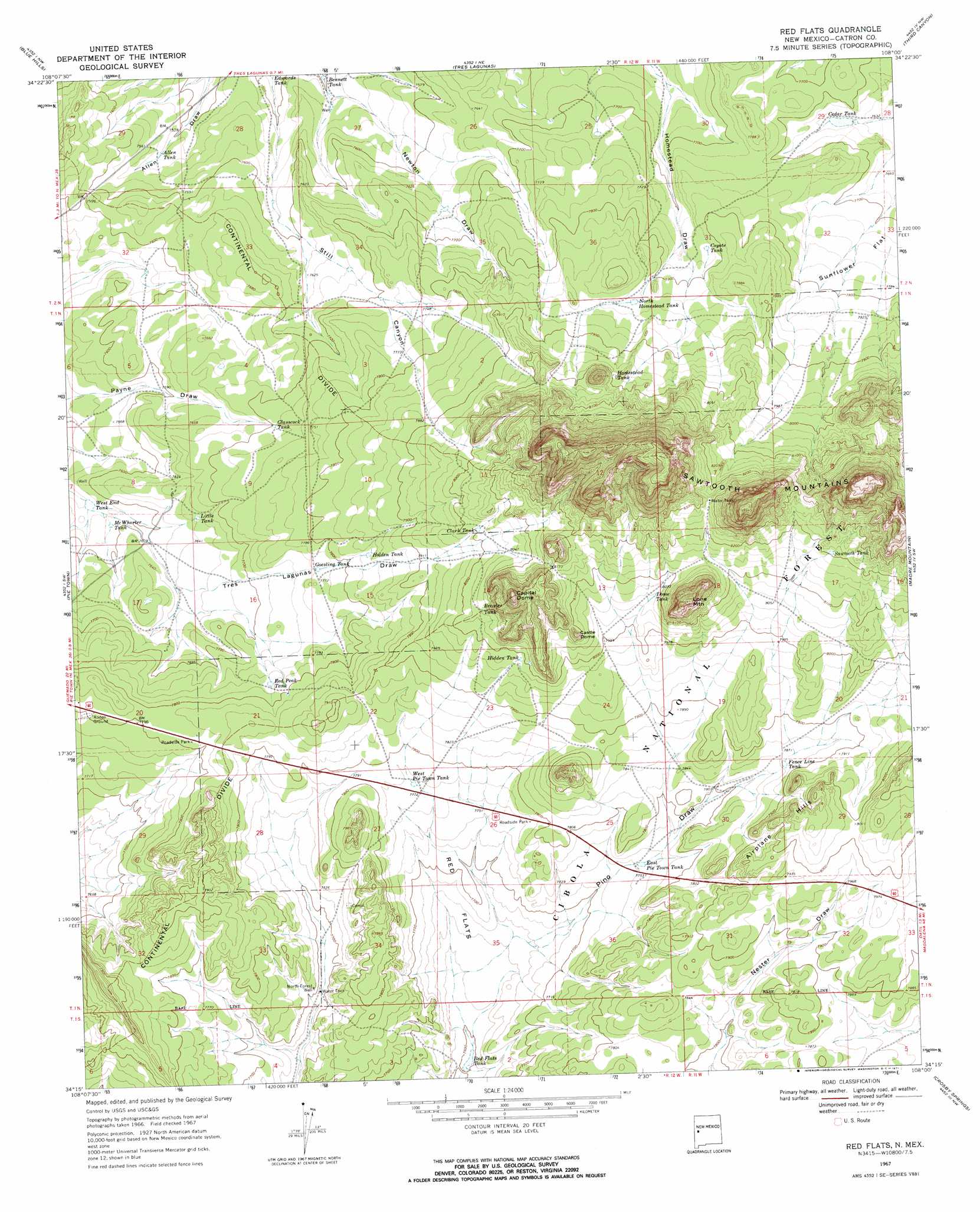
USGS Topo Quad 34108c1 - 1:24,000 scale
| Topo Map Name: | Red Flats |
| USGS Topo Quad ID: | 34108c1 |
| Print Size: | ca. 21 1/4" wide x 27" high |
| Southeast Coordinates: | 34.25° N latitude / 108° W longitude |
| Map Center Coordinates: | 34.3125° N latitude / 108.0625° W longitude |
| U.S. State: | NM |
| Filename: | o34108c1.jpg |
| Download Map JPG Image: | Red Flats topo map 1:24,000 scale |
| Map Type: | Topographic |
| Topo Series: | 7.5´ |
| Map Scale: | 1:24,000 |
| Source of Map Images: | United States Geological Survey (USGS) |
| Alternate Map Versions: |
Red Flats NM 1967, updated 1971 Download PDF Buy paper map Red Flats NM 1995, updated 1998 Download PDF Buy paper map Red Flats NM 2011 Download PDF Buy paper map Red Flats NM 2013 Download PDF Buy paper map Red Flats NM 2017 Download PDF Buy paper map |
| FStopo: | US Forest Service topo Red Flats is available: Download FStopo PDF Download FStopo TIF |
1:24,000 Topo Quads surrounding Red Flats
Veteado Mountain |
Trail Lake |
York Ranch Se |
Bonine Canyon |
Wild Horse Canyon |
Adams Diggings |
Blue Hills |
Tres Lagunas |
Third Canyon |
Pasture Canyon |
Omega |
Pie Town |
Red Flats |
Madre Mountain |
Cal Ship Mesa |
Mangas |
Alegres Mountain |
Cox Peak |
Crosby Springs |
Datil |
Mangas Mountain |
Wallace Mesa |
Log Canyon |
Sugarloaf Mountain |
Anderson Peak |
> Back to 34108a1 at 1:100,000 scale
> Back to 34108a1 at 1:250,000 scale
> Back to U.S. Topo Maps home
Red Flats topo map: Gazetteer
Red Flats: Flats
Red Flats elevation 2328m 7637′Sunflower Flat elevation 2363m 7752′
Red Flats: Reservoirs
Allen Tank elevation 2292m 7519′Bennett Tank elevation 2287m 7503′
Brasier Tank elevation 2454m 8051′
Cedar Tank elevation 2336m 7664′
Clark Tank elevation 2440m 8005′
Coyote Tank elevation 2371m 7778′
Dome Tank elevation 2456m 8057′
East Pie Town Tank elevation 2362m 7749′
Fence Line Tank elevation 2398m 7867′
Glasscock Tank elevation 2351m 7713′
Goesling Tank elevation 2368m 7769′
Hidden Tank elevation 2436m 7992′
Holden Tank elevation 2386m 7828′
Homestead Tank elevation 2437m 7995′
Little Tank elevation 2331m 7647′
McWhorter Tank elevation 2315m 7595′
North Homestead Tank elevation 2385m 7824′
Red Flats Tank elevation 2317m 7601′
Red Peak Tank elevation 2368m 7769′
Sawtooth Tank elevation 2502m 8208′
West End Tank elevation 2307m 7568′
West Pie Town Tank elevation 2371m 7778′
Red Flats: Ridges
Airplane Hills elevation 2464m 8083′Red Flats: Summits
Capital Dome elevation 2605m 8546′Castle Dome elevation 2511m 8238′
Lone Mountain elevation 2632m 8635′
Red Peak elevation 2410m 7906′
Red Flats: Wells
North Forest Well elevation 2354m 7723′West Sawtooth Well elevation 2493m 8179′
Red Flats digital topo map on disk
Buy this Red Flats topo map showing relief, roads, GPS coordinates and other geographical features, as a high-resolution digital map file on DVD: