Mariano Springs Topo Map New Mexico
To zoom in, hover over the map of Mariano Springs
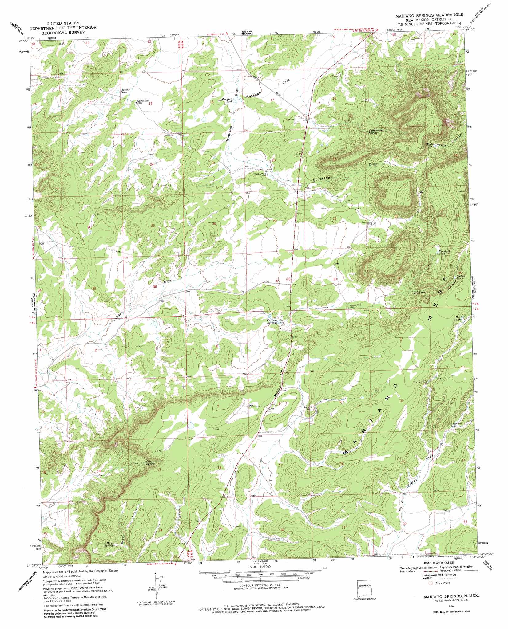
USGS Topo Quad 34108d4 - 1:24,000 scale
| Topo Map Name: | Mariano Springs |
| USGS Topo Quad ID: | 34108d4 |
| Print Size: | ca. 21 1/4" wide x 27" high |
| Southeast Coordinates: | 34.375° N latitude / 108.375° W longitude |
| Map Center Coordinates: | 34.4375° N latitude / 108.4375° W longitude |
| U.S. State: | NM |
| Filename: | o34108d4.jpg |
| Download Map JPG Image: | Mariano Springs topo map 1:24,000 scale |
| Map Type: | Topographic |
| Topo Series: | 7.5´ |
| Map Scale: | 1:24,000 |
| Source of Map Images: | United States Geological Survey (USGS) |
| Alternate Map Versions: |
Mariano Springs NM 1967, updated 1971 Download PDF Buy paper map Mariano Springs NM 1967, updated 1984 Download PDF Buy paper map Mariano Springs NM 2010 Download PDF Buy paper map Mariano Springs NM 2013 Download PDF Buy paper map Mariano Springs NM 2017 Download PDF Buy paper map |
1:24,000 Topo Quads surrounding Mariano Springs
Fence Lake |
The Dyke |
Chimney Hill |
Cerro Pomo |
La Rendija |
Fence Lake Sw |
Cerro Prieto |
Techado |
Veteado Mountain |
Trail Lake |
Lake Armijo |
Tejana Mesa |
Mariano Springs |
Adams Diggings |
Blue Hills |
Tejana Mesa Sw |
Armstrong Canyon |
Quemado |
Omega |
Pie Town |
Pondersoa Tank |
Largo Mesa |
Escondido Mountains |
Mangas |
Alegres Mountain |
> Back to 34108a1 at 1:100,000 scale
> Back to 34108a1 at 1:250,000 scale
> Back to U.S. Topo Maps home
Mariano Springs topo map: Gazetteer
Mariano Springs: Flats
Marshall Flat elevation 2139m 7017′Mariano Springs: Reservoirs
Balm Tank elevation 2364m 7755′Bell Tank elevation 2343m 7687′
Dudley Tank elevation 2338m 7670′
Franklin Tank elevation 2343m 7687′
Marshall Tank elevation 2132m 6994′
Stevens Tank elevation 2115m 6938′
Wyche Tank elevation 2307m 7568′
Mariano Springs: Springs
Baca Spring elevation 2224m 7296′Cole Spring elevation 2212m 7257′
Cottonwood Spring elevation 2227m 7306′
Mariano Springs elevation 2194m 7198′
Mariano Springs: Summits
Mariano Hill elevation 2236m 7335′Mariano Springs: Valleys
Dudley Canyon elevation 2235m 7332′Mariano Springs: Wells
Adobe Well elevation 2272m 7454′Crossman Well elevation 2243m 7358′
Gaines Well elevation 2115m 6938′
Jones Well elevation 2240m 7349′
Tarpley Well elevation 2303m 7555′
Webb Well elevation 2168m 7112′
Mariano Springs digital topo map on disk
Buy this Mariano Springs topo map showing relief, roads, GPS coordinates and other geographical features, as a high-resolution digital map file on DVD: