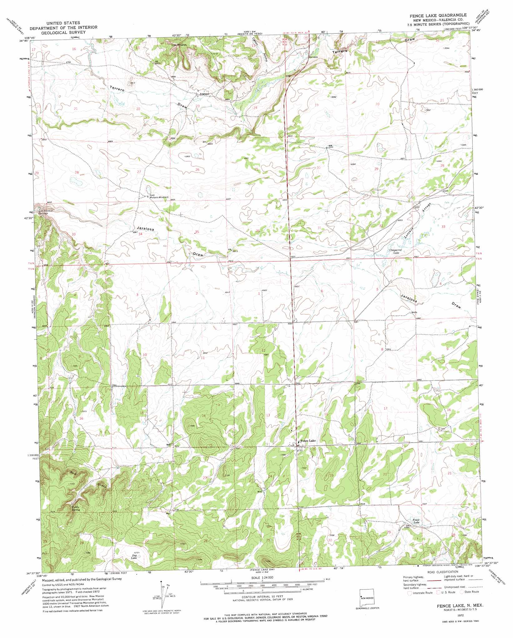
Fence Lake Topo Map New Mexico
To zoom in, hover over the map of Fence Lake
USGS Topo Quad 34108f6 - 1:24,000 scale
| Topo Map Name: | Fence Lake |
| USGS Topo Quad ID: | 34108f6 |
| Print Size: | ca. 21 1/4" wide x 27" high |
| Southeast Coordinates: | 34.625° N latitude / 108.625° W longitude |
| Map Center Coordinates: | 34.6875° N latitude / 108.6875° W longitude |
| U.S. State: | NM |
| Filename: | o34108f6.jpg |
| Download Map JPG Image: | Fence Lake topo map 1:24,000 scale |
| Map Type: | Topographic |
| Topo Series: | 7.5´ |
| Map Scale: | 1:24,000 |
| Source of Map Images: | United States Geological Survey (USGS) |
| Alternate Map Versions: |
Fence Lake NM 1972, updated 1976 Download PDF Buy paper map Fence Lake NM 2010 Download PDF Buy paper map Fence Lake NM 2013 Download PDF Buy paper map Fence Lake NM 2017 Download PDF Buy paper map |
1:24,000 Topo Quads surrounding Fence Lake
Ojo Caliente Reservoir |
Plumasano Basin |
Upper Galestina Canyon |
Shoemaker Canyon |
Nicoll Lake |
Venadito Camp |
Atarque Lake |
Mesita De Yeso |
Shoemaker Canyon Se |
Red Lake Mission |
Cantaralo Spring |
Rincon Hondo |
Fence Lake |
The Dyke |
Chimney Hill |
Twentytwo Spring |
Moreno Hill |
Fence Lake Sw |
Cerro Prieto |
Techado |
Salazar Canyon |
Zuni Salt Lake |
Lake Armijo |
Tejana Mesa |
Mariano Springs |
> Back to 34108e1 at 1:100,000 scale
> Back to 34108a1 at 1:250,000 scale
> Back to U.S. Topo Maps home
Fence Lake topo map: Gazetteer
Fence Lake: Cliffs
Red Cliffs elevation 2222m 7290′Fence Lake: Lakes
Chaparral Lake elevation 2114m 6935′Dog Lake elevation 2220m 7283′
Fence Lake elevation 2131m 6991′
Fence Lake: Populated Places
Atarque elevation 2071m 6794′Fence Lake elevation 2156m 7073′
Fence Lake: Post Offices
Atarque Post Office (historical) elevation 2071m 6794′Fence Lake Post Office elevation 2156m 7073′
Fence Lake: Springs
Cabin Spring elevation 2240m 7349′Los Alamos Springs elevation 2053m 6735′
Fence Lake: Streams
Lorenzo Arroyo elevation 2115m 6938′Fence Lake: Summits
Los Pilares elevation 2106m 6909′Fence Lake: Valleys
Cañon Ancho elevation 2076m 6811′Fence Lake: Wells
Jacobine Water Well elevation 2134m 7001′Fence Lake digital topo map on disk
Buy this Fence Lake topo map showing relief, roads, GPS coordinates and other geographical features, as a high-resolution digital map file on DVD: