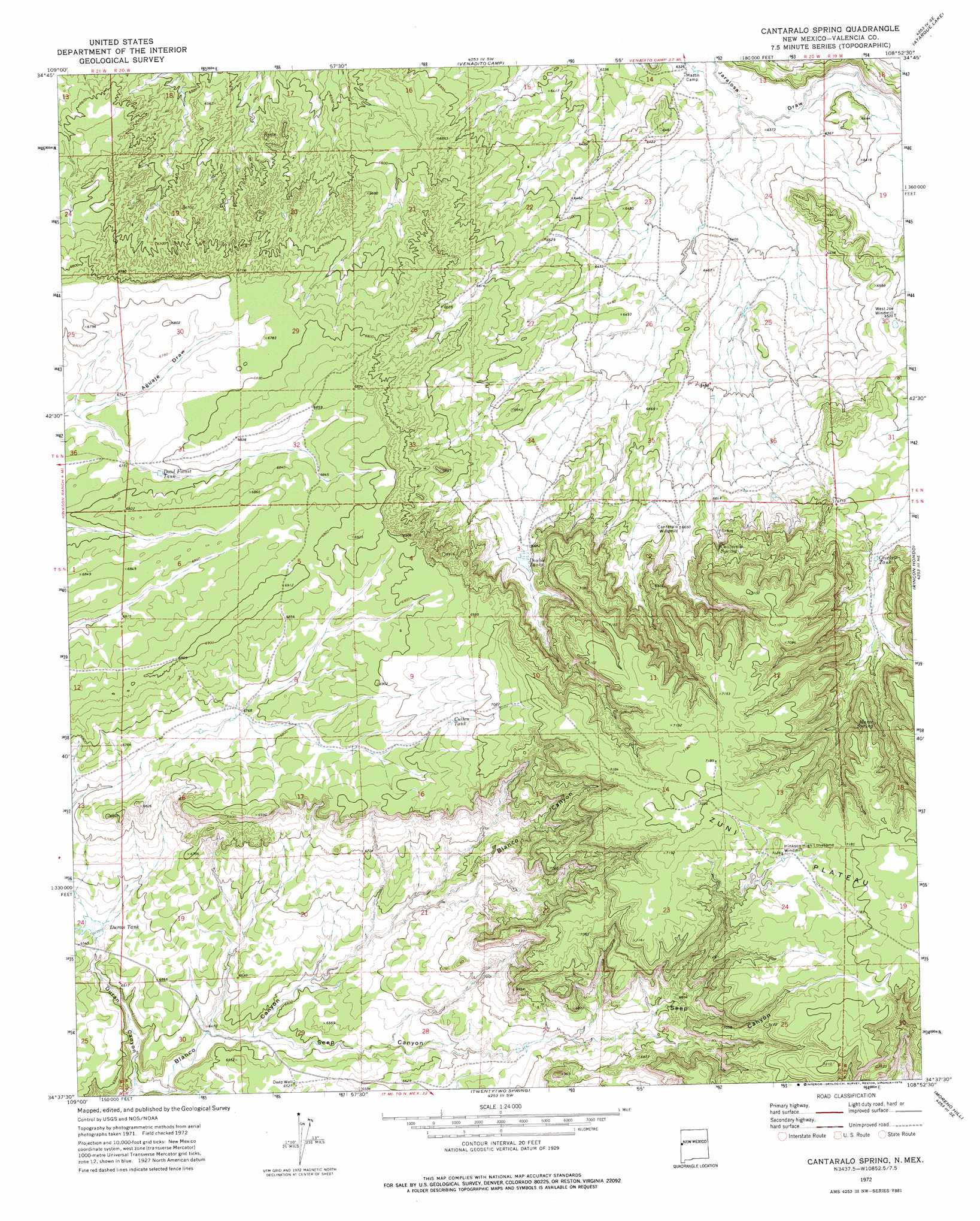
Cantaralo Spring Topo Map New Mexico
To zoom in, hover over the map of Cantaralo Spring
USGS Topo Quad 34108f8 - 1:24,000 scale
| Topo Map Name: | Cantaralo Spring |
| USGS Topo Quad ID: | 34108f8 |
| Print Size: | ca. 21 1/4" wide x 27" high |
| Southeast Coordinates: | 34.625° N latitude / 108.875° W longitude |
| Map Center Coordinates: | 34.6875° N latitude / 108.9375° W longitude |
| U.S. State: | NM |
| Filename: | o34108f8.jpg |
| Download Map JPG Image: | Cantaralo Spring topo map 1:24,000 scale |
| Map Type: | Topographic |
| Topo Series: | 7.5´ |
| Map Scale: | 1:24,000 |
| Source of Map Images: | United States Geological Survey (USGS) |
| Alternate Map Versions: |
Cantaralo Spring NM 1972, updated 1976 Download PDF Buy paper map Cantaralo Spring NM 2010 Download PDF Buy paper map Cantaralo Spring NM 2013 Download PDF Buy paper map Cantaralo Spring NM 2017 Download PDF Buy paper map |
1:24,000 Topo Quads surrounding Cantaralo Spring
Wild Cow Lake |
Barth Well |
Ojo Caliente Reservoir |
Plumasano Basin |
Upper Galestina Canyon |
Ceadro Spring |
Ceadro Spring Se |
Venadito Camp |
Atarque Lake |
Mesita De Yeso |
Valle Bonito |
Valle Bonito Ne |
Cantaralo Spring |
Rincon Hondo |
Fence Lake |
Kearn Lake |
Carrisito Spring |
Twentytwo Spring |
Moreno Hill |
Fence Lake Sw |
Mesa Parada Nw |
Mesa Parada |
Salazar Canyon |
Zuni Salt Lake |
Lake Armijo |
> Back to 34108e1 at 1:100,000 scale
> Back to 34108a1 at 1:250,000 scale
> Back to U.S. Topo Maps home
Cantaralo Spring topo map: Gazetteer
Cantaralo Spring: Areas
Zuñi Plateau elevation 2199m 7214′Cantaralo Spring: Reservoirs
Crockett Tank elevation 2042m 6699′Cullen Tank elevation 2117m 6945′
Dead Forest Tank elevation 2062m 6765′
Double Tanks elevation 2041m 6696′
Duran Tank elevation 1994m 6541′
Cantaralo Spring: Springs
Cantaralo Spring elevation 2082m 6830′Marez Spring elevation 2124m 6968′
Cantaralo Spring: Valleys
Duran Canyon elevation 1944m 6377′Seep Canyon elevation 1968m 6456′
Cantaralo Spring: Wells
Barth High Water Well elevation 2192m 7191′Deep Well elevation 1988m 6522′
Hinkson Hi Water Well elevation 2177m 7142′
Mazon Water Well elevation 1939m 6361′
West Joe Water Well elevation 1994m 6541′
Cantaralo Spring digital topo map on disk
Buy this Cantaralo Spring topo map showing relief, roads, GPS coordinates and other geographical features, as a high-resolution digital map file on DVD: