Cerro Hueco Topo Map New Mexico
To zoom in, hover over the map of Cerro Hueco
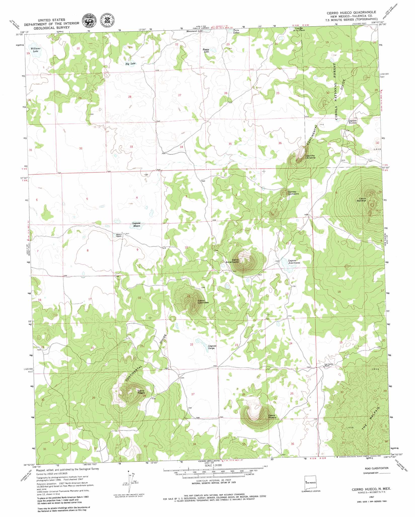
USGS Topo Quad 34108h2 - 1:24,000 scale
| Topo Map Name: | Cerro Hueco |
| USGS Topo Quad ID: | 34108h2 |
| Print Size: | ca. 21 1/4" wide x 27" high |
| Southeast Coordinates: | 34.875° N latitude / 108.125° W longitude |
| Map Center Coordinates: | 34.9375° N latitude / 108.1875° W longitude |
| U.S. State: | NM |
| Filename: | o34108h2.jpg |
| Download Map JPG Image: | Cerro Hueco topo map 1:24,000 scale |
| Map Type: | Topographic |
| Topo Series: | 7.5´ |
| Map Scale: | 1:24,000 |
| Source of Map Images: | United States Geological Survey (USGS) |
| Alternate Map Versions: |
Cerro Hueco NM 1967, updated 1971 Download PDF Buy paper map Cerro Hueco NM 1967, updated 1980 Download PDF Buy paper map Cerro Hueco NM 1995, updated 1998 Download PDF Buy paper map Cerro Hueco NM 2011 Download PDF Buy paper map Cerro Hueco NM 2013 Download PDF Buy paper map Cerro Hueco NM 2017 Download PDF Buy paper map |
| FStopo: | US Forest Service topo Cerro Hueco is available: Download FStopo PDF Download FStopo TIF |
1:24,000 Topo Quads surrounding Cerro Hueco
Ramah |
Kettner Canyon |
Post Office Flat |
Mount Sedgwick |
Milan |
Togeye Lake |
El Morro |
Valle Largo |
Paxton Springs |
San Rafael |
Nicoll Lake |
Goat Hill |
Cerro Hueco |
Ice Caves |
Arrosa Ranch |
Red Lake Mission |
Cerro Alto |
Cerro Brilliante |
Ice Caves Se |
North Pasture |
Chimney Hill |
Cerro Pomo |
La Rendija |
York Ranch |
Sand Canyon |
> Back to 34108e1 at 1:100,000 scale
> Back to 34108a1 at 1:250,000 scale
> Back to U.S. Topo Maps home
Cerro Hueco topo map: Gazetteer
Cerro Hueco: Lakes
Big Lake elevation 2292m 7519′Boggy Lake elevation 2330m 7644′
Laguna Americana elevation 2308m 7572′
Laguna Juan Garcia elevation 2358m 7736′
Laguna Larga elevation 2304m 7559′
Laguna Mason elevation 2279m 7477′
Laguna Tarrito elevation 2353m 7719′
Twin Lakes elevation 2324m 7624′
Williams Lake elevation 2250m 7381′
Cerro Hueco: Summits
Cerrito Arizona elevation 2359m 7739′Cerrito Comadre elevation 2359m 7739′
Cerro Americano elevation 2455m 8054′
Cerro Hueco elevation 2419m 7936′
Cerro Leonides elevation 2416m 7926′
Cerro Negro elevation 2490m 8169′
Cerro Rendija elevation 2487m 8159′
Jacks Peak elevation 2312m 7585′
Cerro Hueco digital topo map on disk
Buy this Cerro Hueco topo map showing relief, roads, GPS coordinates and other geographical features, as a high-resolution digital map file on DVD: