Greens Peak Topo Map Arizona
To zoom in, hover over the map of Greens Peak
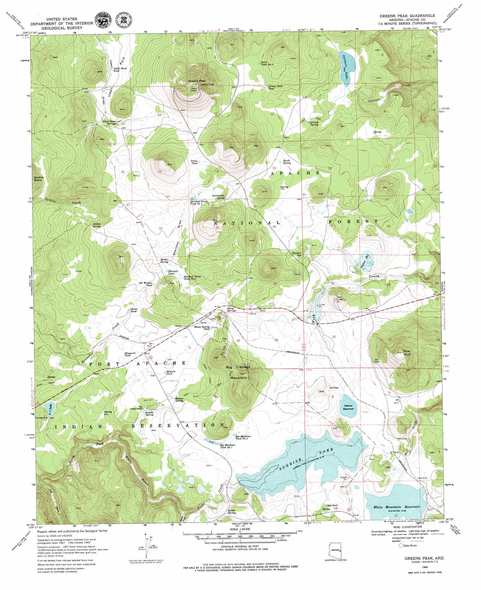
USGS Topo Quad 34109a5 - 1:24,000 scale
| Topo Map Name: | Greens Peak |
| USGS Topo Quad ID: | 34109a5 |
| Print Size: | ca. 21 1/4" wide x 27" high |
| Southeast Coordinates: | 34° N latitude / 109.5° W longitude |
| Map Center Coordinates: | 34.0625° N latitude / 109.5625° W longitude |
| U.S. State: | AZ |
| Filename: | o34109a5.jpg |
| Download Map JPG Image: | Greens Peak topo map 1:24,000 scale |
| Map Type: | Topographic |
| Topo Series: | 7.5´ |
| Map Scale: | 1:24,000 |
| Source of Map Images: | United States Geological Survey (USGS) |
| Alternate Map Versions: |
Greens Peak AZ 1969, updated 1972 Download PDF Buy paper map Greens Peak AZ 1969, updated 1979 Download PDF Buy paper map Greens Peak AZ 1975, updated 1977 Download PDF Buy paper map Greens Peak AZ 1997, updated 2000 Download PDF Buy paper map Greens Peak AZ 2011 Download PDF Buy paper map Greens Peak AZ 2014 Download PDF Buy paper map |
| FStopo: | US Forest Service topo Greens Peak is available: Download FStopo PDF Download FStopo TIF |
1:24,000 Topo Quads surrounding Greens Peak
Ortega Mountain |
Vernon |
Cerro Hueco |
Lyman Lake Sw |
Lyman Lake |
Sponseller Mountain |
Boundary Butte |
Whiting Knoll |
Springerville Nw |
Springerville |
Mcnary |
Horseshoe Cienega |
Greens Peak |
Greer |
Eagar |
Hawley Lake West |
Hawley Lake East |
Mount Baldy |
Big Lake North |
Rudd Knoll |
Corn Creek Plateau |
Marshall Butte |
Bonito Rock |
Big Lake South |
Buffalo Crossing |
> Back to 34109a1 at 1:100,000 scale
> Back to 34108a1 at 1:250,000 scale
> Back to U.S. Topo Maps home
Greens Peak topo map: Gazetteer
Greens Peak: Arroyos
Horse Camp Draw elevation 2792m 9160′Greens Peak: Basins
Border Sink elevation 2737m 8979′Gadwell Sink elevation 2793m 9163′
Loop Sink Number One elevation 2760m 9055′
Loop Sink Number Two elevation 2760m 9055′
Pothole Sink elevation 2756m 9041′
Teal Sink elevation 2799m 9183′
Greens Peak: Dams
A One Dam elevation 2698m 8851′Norton Dam elevation 2750m 9022′
Sheep Springs Dam elevation 2783m 9130′
Sunnyside Dam elevation 2771m 9091′
Sunrise Dam elevation 2774m 9101′
White Mountain Dam elevation 2794m 9166′
Greens Peak: Flats
Udall Park elevation 2804m 9199′Greens Peak: Lakes
Carnero Lake elevation 2755m 9038′Greens Peak: Parks
Sunrise Park elevation 2794m 9166′Greens Peak: Reservoirs
A One Lake elevation 2696m 8845′Aspen Tank elevation 2855m 9366′
Bear Wallow Tank elevation 2824m 9265′
Big Meadows Tank Number One elevation 2778m 9114′
Big Meadows Tank Number Two elevation 2786m 9140′
Bighole Tank elevation 2576m 8451′
Carnero Tank elevation 2576m 8451′
Draw Tank elevation 2828m 9278′
Draw Tank elevation 2775m 9104′
Dry Tank elevation 2816m 9238′
Ed Walker Tank elevation 2817m 9242′
Fence Tank elevation 2914m 9560′
Fish Tank elevation 2753m 9032′
Geneva Reservoir elevation 2783m 9130′
Grassy Tank elevation 2840m 9317′
Green Tank elevation 2778m 9114′
Greens Peak Tank elevation 2816m 9238′
Halls Tank Number Three elevation 2824m 9265′
Little Stock Tank elevation 2846m 9337′
Little Tank elevation 2863m 9393′
Natural Tank elevation 2871m 9419′
North Spring Tank elevation 2825m 9268′
Norton Reservoir elevation 2750m 9022′
Pasture Tank elevation 2774m 9101′
Railroad Tank elevation 2792m 9160′
Roadside Tank elevation 2860m 9383′
Seep Tank elevation 2896m 9501′
Sheep Spring Tank elevation 2789m 9150′
Sheep Tank elevation 2799m 9183′
Sherlock Draw Tank Number One elevation 2888m 9475′
Sherlock Draw Tank Number Two elevation 2828m 9278′
Sherlock Tank elevation 2823m 9261′
Shipyard Tank elevation 2766m 9074′
Snake Creek Tank Number One elevation 2780m 9120′
Struck Tank elevation 2896m 9501′
Sunnyside Reservoir elevation 2771m 9091′
Sunrise Lake elevation 2786m 9140′
Swinbourne Tank elevation 2860m 9383′
Udall Park Tank elevation 2800m 9186′
Udall Park Tanks elevation 2807m 9209′
White Mountain Reservoir elevation 2794m 9166′
Wooly Tank elevation 2823m 9261′
Greens Peak: Springs
117 C Spring elevation 2776m 9107′Apache Spring elevation 2747m 9012′
Becker Spring elevation 2836m 9304′
Beehive Spring elevation 2791m 9156′
Beehive Spring Number Two elevation 2769m 9084′
Carnero Spring elevation 2773m 9097′
CC Hall Spring elevation 2816m 9238′
Horse Camp Draw Springs elevation 2792m 9160′
Kessay Spring elevation 2774m 9101′
Lost Spring elevation 2775m 9104′
Mac Spring elevation 2774m 9101′
Middle Spring elevation 2559m 8395′
North Spring elevation 2822m 9258′
Sheep Camp Spring elevation 2793m 9163′
Sheep Spring elevation 2792m 9160′
Snake Spring elevation 2773m 9097′
Soldier Spring elevation 2806m 9206′
Swinborne Spring elevation 2865m 9399′
Twin Spring elevation 2542m 8339′
Udall Draw Spring Number 1 elevation 2839m 9314′
Udall Draw Springs elevation 2835m 9301′
Udall Park Spring elevation 2855m 9366′
Udall Park Spring Number 1 elevation 2834m 9297′
Upper Spring elevation 2554m 8379′
Greens Peak: Streams
Becker Creek elevation 2724m 8937′Ord Creek elevation 2590m 8497′
Smith Creek elevation 2630m 8628′
Snake Creek elevation 2724m 8937′
Greens Peak: Summits
Big Cienega Mountain elevation 2928m 9606′Greens Peak elevation 3089m 10134′
Pole Knoll elevation 2983m 9786′
Greens Peak: Valleys
Sherlock Draw elevation 2822m 9258′Greens Peak digital topo map on disk
Buy this Greens Peak topo map showing relief, roads, GPS coordinates and other geographical features, as a high-resolution digital map file on DVD: