Sponseller Mountain Topo Map Arizona
To zoom in, hover over the map of Sponseller Mountain
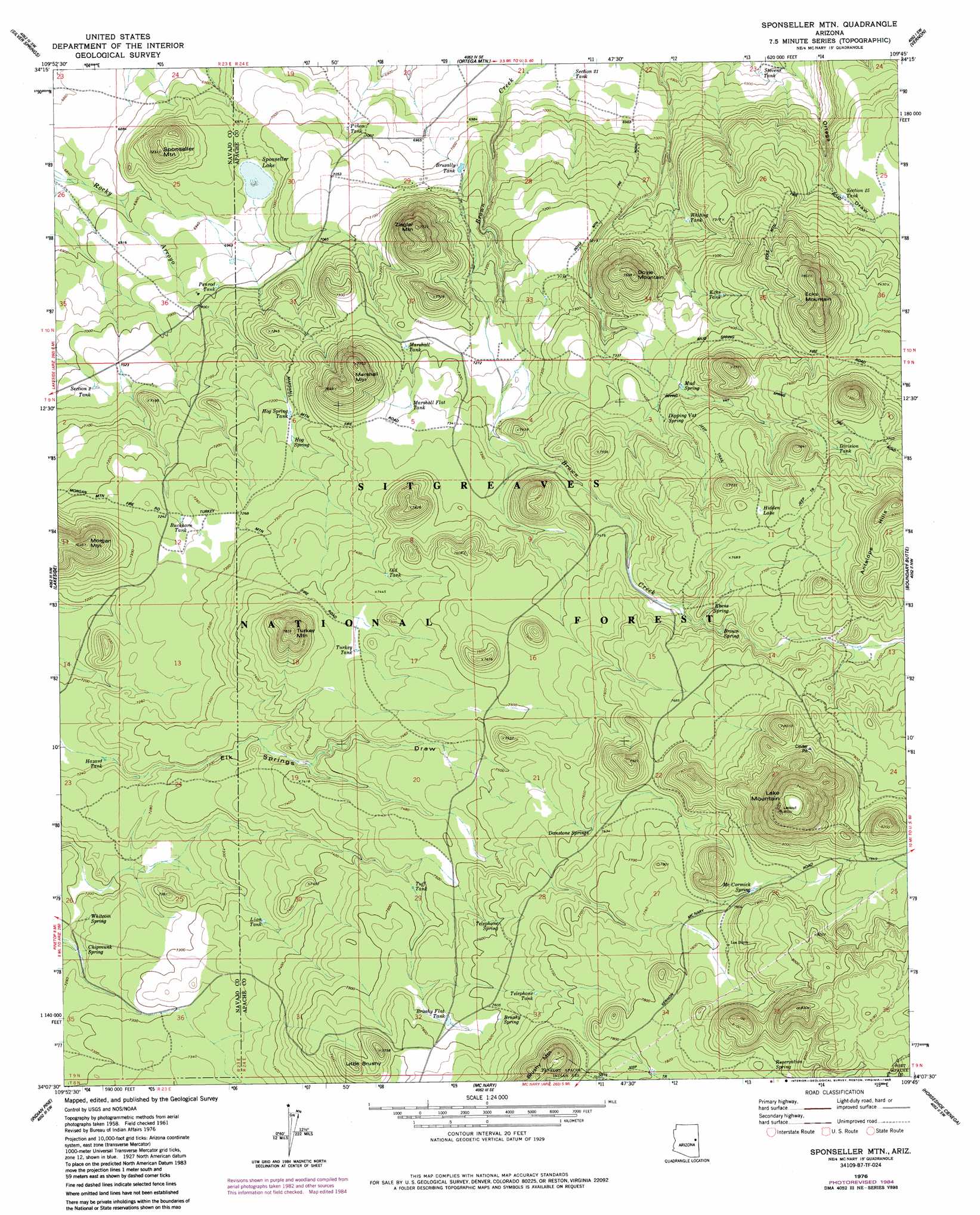
USGS Topo Quad 34109b7 - 1:24,000 scale
| Topo Map Name: | Sponseller Mountain |
| USGS Topo Quad ID: | 34109b7 |
| Print Size: | ca. 21 1/4" wide x 27" high |
| Southeast Coordinates: | 34.125° N latitude / 109.75° W longitude |
| Map Center Coordinates: | 34.1875° N latitude / 109.8125° W longitude |
| U.S. State: | AZ |
| Filename: | o34109b7.jpg |
| Download Map JPG Image: | Sponseller Mountain topo map 1:24,000 scale |
| Map Type: | Topographic |
| Topo Series: | 7.5´ |
| Map Scale: | 1:24,000 |
| Source of Map Images: | United States Geological Survey (USGS) |
| Alternate Map Versions: |
Sponseller Mtn. AZ 1976, updated 1985 Download PDF Buy paper map Sponseller Mtn. AZ 1976, updated 1985 Download PDF Buy paper map Sponseller Mtn. AZ 1977, updated 1978 Download PDF Buy paper map Sponseller Mountain AZ 1998, updated 2001 Download PDF Buy paper map Sponseller Mountain AZ 2011 Download PDF Buy paper map Sponseller Mountain AZ 2014 Download PDF Buy paper map |
| FStopo: | US Forest Service topo Sponseller Mountain is available: Download FStopo PDF Download FStopo TIF |
1:24,000 Topo Quads surrounding Sponseller Mountain
Taylor |
Mesa Redonda Nw |
Mesa Redonda |
Concho Lake |
Concho |
Show Low North |
Silver Springs |
Ortega Mountain |
Vernon |
Cerro Hueco |
Show Low South |
Lakeside |
Sponseller Mountain |
Boundary Butte |
Whiting Knoll |
Faught Ridge |
Indian Pine |
Mcnary |
Horseshoe Cienega |
Greens Peak |
Round Top Mountain |
Alchesay Flat |
Hawley Lake West |
Hawley Lake East |
Mount Baldy |
> Back to 34109a1 at 1:100,000 scale
> Back to 34108a1 at 1:250,000 scale
> Back to U.S. Topo Maps home
Sponseller Mountain topo map: Gazetteer
Sponseller Mountain: Lakes
Hidden Lake elevation 2344m 7690′Sponseller Lake elevation 2122m 6961′
Sponseller Mountain: Populated Places
Los Burros elevation 2385m 7824′Sponseller Mountain: Reservoirs
Apprentice Tank elevation 2263m 7424′Bear Wallow Tank elevation 2481m 8139′
Brusally Tank elevation 2141m 7024′
Brushy Flat Tank elevation 2311m 7582′
Brushy Mountain Tank elevation 2239m 7345′
Buckhorn Tank elevation 2207m 7240′
Division Tank elevation 2335m 7660′
Division Tank elevation 2425m 7956′
Dougout Tanks elevation 2128m 6981′
Ecks Tank elevation 2243m 7358′
Fantasia Tank elevation 2214m 7263′
Fleming Tank elevation 2145m 7037′
Gandale Tank elevation 2220m 7283′
Hazard Tank elevation 2199m 7214′
Hog Spring Tank elevation 2199m 7214′
Homestead Tank elevation 2107m 6912′
Liegler Tank elevation 2156m 7073′
Lion Tank elevation 2236m 7335′
Marshall Flat Tank elevation 2238m 7342′
Marshall Tank elevation 2218m 7276′
Merlyn Tank elevation 2219m 7280′
Mortimer Tank elevation 2238m 7342′
Nancy Tanks elevation 2131m 6991′
Old Tank elevation 2263m 7424′
Penrod Number One Tank elevation 2123m 6965′
Penrod Tank elevation 2132m 6994′
Piñon Tank elevation 2126m 6975′
Reservation Tank elevation 2379m 7805′
Section Twenty Three Tank elevation 2095m 6873′
Section Twentyfive Tank elevation 2199m 7214′
Section Twentyone Tank elevation 2109m 6919′
Section Two Tank elevation 2141m 7024′
Stevens Tank elevation 2098m 6883′
Telephone Tank elevation 2333m 7654′
Trap Tank elevation 2343m 7687′
Tuff Tank elevation 2277m 7470′
Turkey Tank elevation 2266m 7434′
Whiting Tank elevation 2173m 7129′
Sponseller Mountain: Springs
Brown Spring elevation 2310m 7578′Brushy Spring elevation 2319m 7608′
Chipmunk Spring elevation 2209m 7247′
Danstone Springs elevation 2320m 7611′
Dipping Vat Spring elevation 2264m 7427′
Ebens Spring elevation 2315m 7595′
Hog Spring elevation 2207m 7240′
Los Burros Spring elevation 2388m 7834′
McCormick Spring elevation 2382m 7814′
Mud Spring elevation 2257m 7404′
Reservation Spring elevation 2408m 7900′
Telephone Spring elevation 2317m 7601′
Whitcom Spring elevation 2207m 7240′
Sponseller Mountain: Summits
Doyle Mountain elevation 2330m 7644′Ecks Mountain elevation 2397m 7864′
Lake Mountain elevation 2588m 8490′
Little Brushy elevation 2360m 7742′
Marshall Mountain elevation 2348m 7703′
McCormick Knoll elevation 2434m 7985′
Morgan Mountain elevation 2331m 7647′
Mud Spring Knoll elevation 2363m 7752′
Pulp Burn Knoll elevation 2508m 8228′
Sponseller Mountain elevation 2203m 7227′
Turkey Mountain elevation 2385m 7824′
Ziegler Mountain elevation 2345m 7693′
Sponseller Mountain digital topo map on disk
Buy this Sponseller Mountain topo map showing relief, roads, GPS coordinates and other geographical features, as a high-resolution digital map file on DVD: