Vernon Topo Map Arizona
To zoom in, hover over the map of Vernon
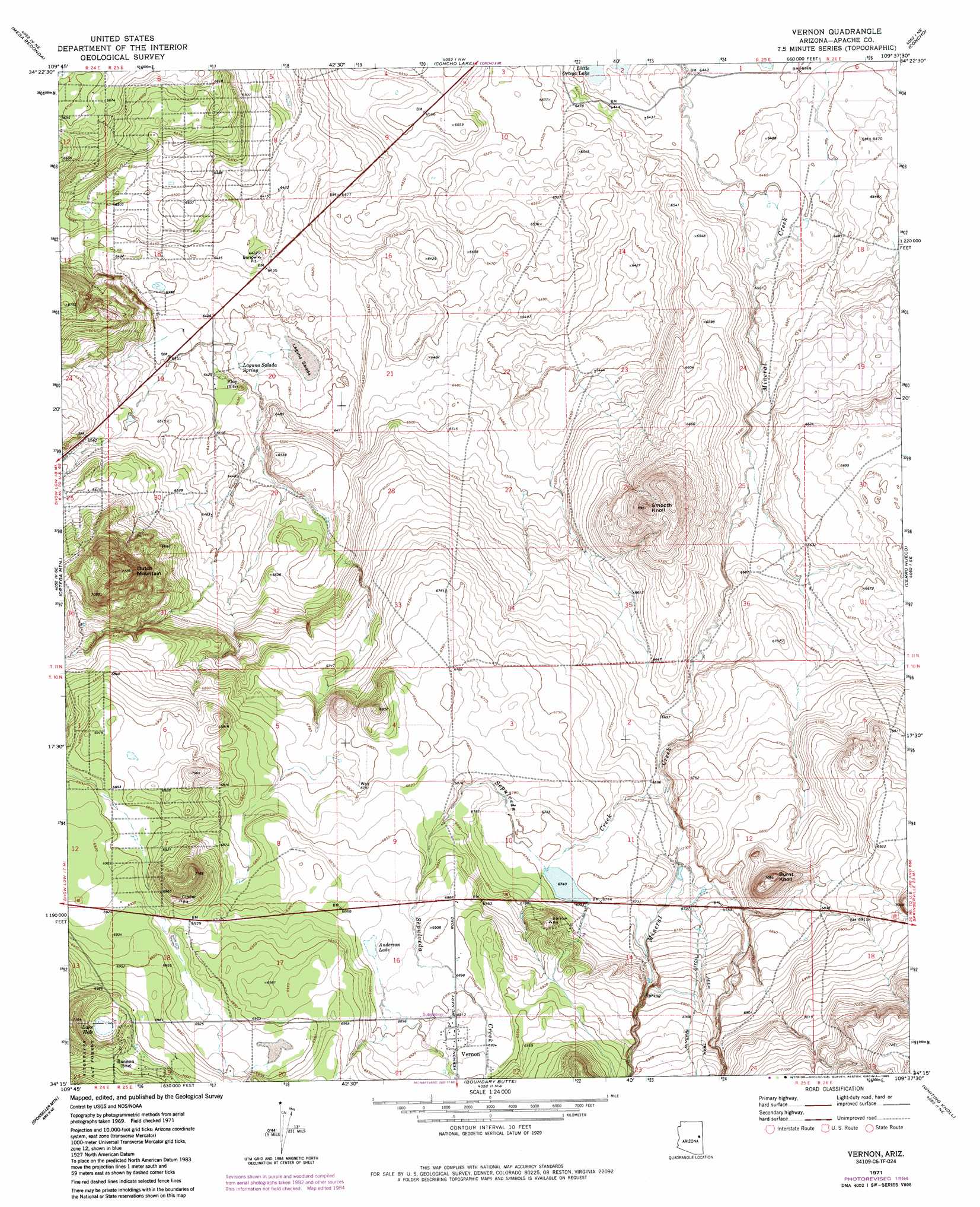
USGS Topo Quad 34109c6 - 1:24,000 scale
| Topo Map Name: | Vernon |
| USGS Topo Quad ID: | 34109c6 |
| Print Size: | ca. 21 1/4" wide x 27" high |
| Southeast Coordinates: | 34.25° N latitude / 109.625° W longitude |
| Map Center Coordinates: | 34.3125° N latitude / 109.6875° W longitude |
| U.S. State: | AZ |
| Filename: | o34109c6.jpg |
| Download Map JPG Image: | Vernon topo map 1:24,000 scale |
| Map Type: | Topographic |
| Topo Series: | 7.5´ |
| Map Scale: | 1:24,000 |
| Source of Map Images: | United States Geological Survey (USGS) |
| Alternate Map Versions: |
Vernon AZ 1971, updated 1973 Download PDF Buy paper map Vernon AZ 1971, updated 1985 Download PDF Buy paper map Vernon AZ 1971, updated 1985 Download PDF Buy paper map Vernon AZ 1998, updated 2000 Download PDF Buy paper map Vernon AZ 2011 Download PDF Buy paper map Vernon AZ 2014 Download PDF Buy paper map |
| FStopo: | US Forest Service topo Vernon is available: Download FStopo PDF Download FStopo TIF |
1:24,000 Topo Quads surrounding Vernon
Point Of The Mountain |
Manuel Seep |
Hunt |
Stinking Springs |
Zion Reservoir |
Mesa Redonda Nw |
Mesa Redonda |
Concho Lake |
Concho |
Salado |
Silver Springs |
Ortega Mountain |
Vernon |
Cerro Hueco |
Lyman Lake Sw |
Lakeside |
Sponseller Mountain |
Boundary Butte |
Whiting Knoll |
Springerville Nw |
Indian Pine |
Mcnary |
Horseshoe Cienega |
Greens Peak |
Greer |
> Back to 34109a1 at 1:100,000 scale
> Back to 34108a1 at 1:250,000 scale
> Back to U.S. Topo Maps home
Vernon topo map: Gazetteer
Vernon: Lakes
Anderson Lake elevation 2101m 6893′Laguna Salada elevation 1945m 6381′
Lake Hole elevation 2125m 6971′
Vernon: Populated Places
Vernon elevation 2107m 6912′Vernon: Post Offices
Vernon Post Office (historical) elevation 2107m 6912′Vernon: Springs
Laguna Salada Spring elevation 1948m 6391′Vernon: Streams
Sepulveda Creek elevation 2034m 6673′Vernon: Summits
Burnt Knoll elevation 2154m 7066′Dutch Mountain elevation 2146m 7040′
Smooth Knoll elevation 2118m 6948′
Vernon: Valleys
Whiting Wash elevation 2044m 6706′Vernon digital topo map on disk
Buy this Vernon topo map showing relief, roads, GPS coordinates and other geographical features, as a high-resolution digital map file on DVD: