Padilla Tank Topo Map Arizona
To zoom in, hover over the map of Padilla Tank
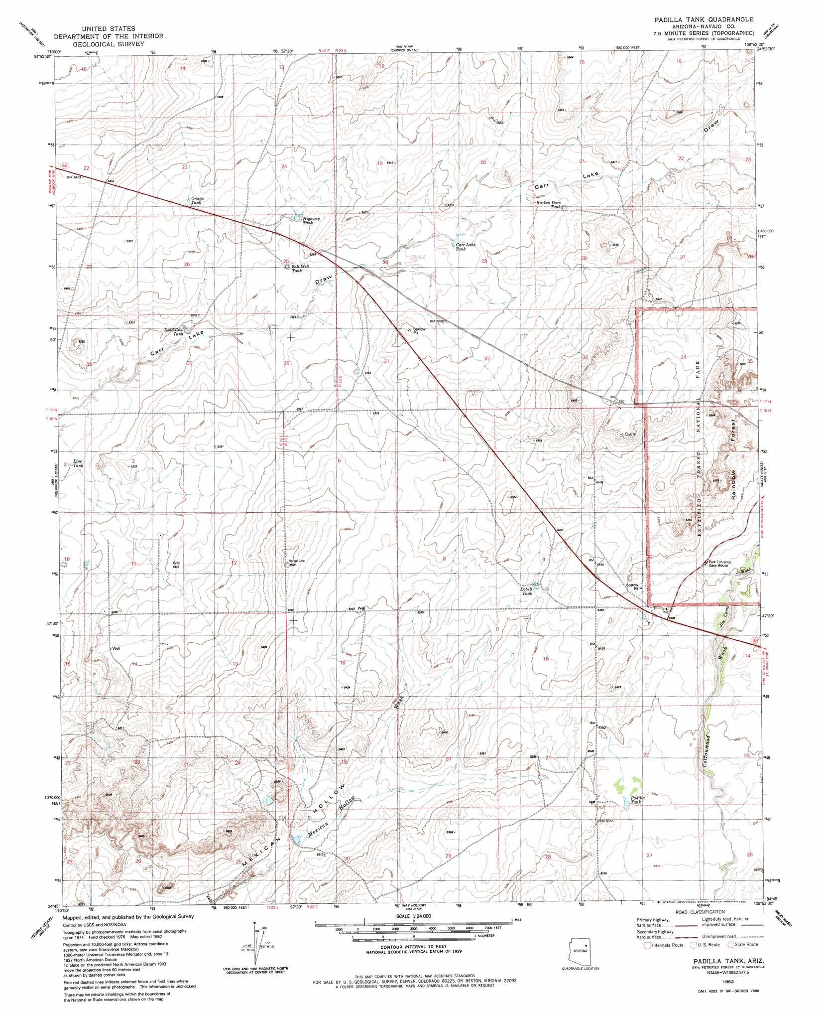
USGS Topo Quad 34109g8 - 1:24,000 scale
| Topo Map Name: | Padilla Tank |
| USGS Topo Quad ID: | 34109g8 |
| Print Size: | ca. 21 1/4" wide x 27" high |
| Southeast Coordinates: | 34.75° N latitude / 109.875° W longitude |
| Map Center Coordinates: | 34.8125° N latitude / 109.9375° W longitude |
| U.S. State: | AZ |
| Filename: | o34109g8.jpg |
| Download Map JPG Image: | Padilla Tank topo map 1:24,000 scale |
| Map Type: | Topographic |
| Topo Series: | 7.5´ |
| Map Scale: | 1:24,000 |
| Source of Map Images: | United States Geological Survey (USGS) |
| Alternate Map Versions: |
Padilla Tank AZ 1982, updated 1983 Download PDF Buy paper map Padilla Tank AZ 2011 Download PDF Buy paper map Padilla Tank AZ 2014 Download PDF Buy paper map |
1:24,000 Topo Quads surrounding Padilla Tank
Lee Mountain |
Hennessy Buttes |
Little Lithodendron Tank |
Kachina Point |
Pinta |
Holbrook |
Sun Valley |
Carrizo Butte |
Adamana |
Sorrel Horse Mesa |
Porter Canyon |
Woodruff |
Padilla Tank |
Agate House |
Milky Ranch |
Flattop Hill |
Tenmile Cedars |
Hay Hollow |
Little Milky Wash |
Potter Mesa Tank |
Second Knolls |
Snowflake |
Point Of The Mountain |
Manuel Seep |
Hunt |
> Back to 34109e1 at 1:100,000 scale
> Back to 34108a1 at 1:250,000 scale
> Back to U.S. Topo Maps home
Padilla Tank topo map: Gazetteer
Padilla Tank: Areas
Rainbow Forest elevation 1659m 5442′Padilla Tank: Lakes
Carr Lake elevation 1639m 5377′Padilla Tank: Reservoirs
Broken Dam Tank elevation 1651m 5416′Carr Lake Tank elevation 1638m 5374′
Dead Cow Tank elevation 1616m 5301′
Dobell Tank elevation 1653m 5423′
Higway Tank elevation 1632m 5354′
Line Tank elevation 1610m 5282′
Ortega Tank elevation 1640m 5380′
Padilla Tank elevation 1626m 5334′
Salt Well Tank elevation 1625m 5331′
Padilla Tank: Streams
Jim Camp Wash elevation 1641m 5383′Padilla Tank: Wells
Salt Well elevation 0m 0′Padilla Tank digital topo map on disk
Buy this Padilla Tank topo map showing relief, roads, GPS coordinates and other geographical features, as a high-resolution digital map file on DVD: