Gentry Mountain Topo Map Arizona
To zoom in, hover over the map of Gentry Mountain
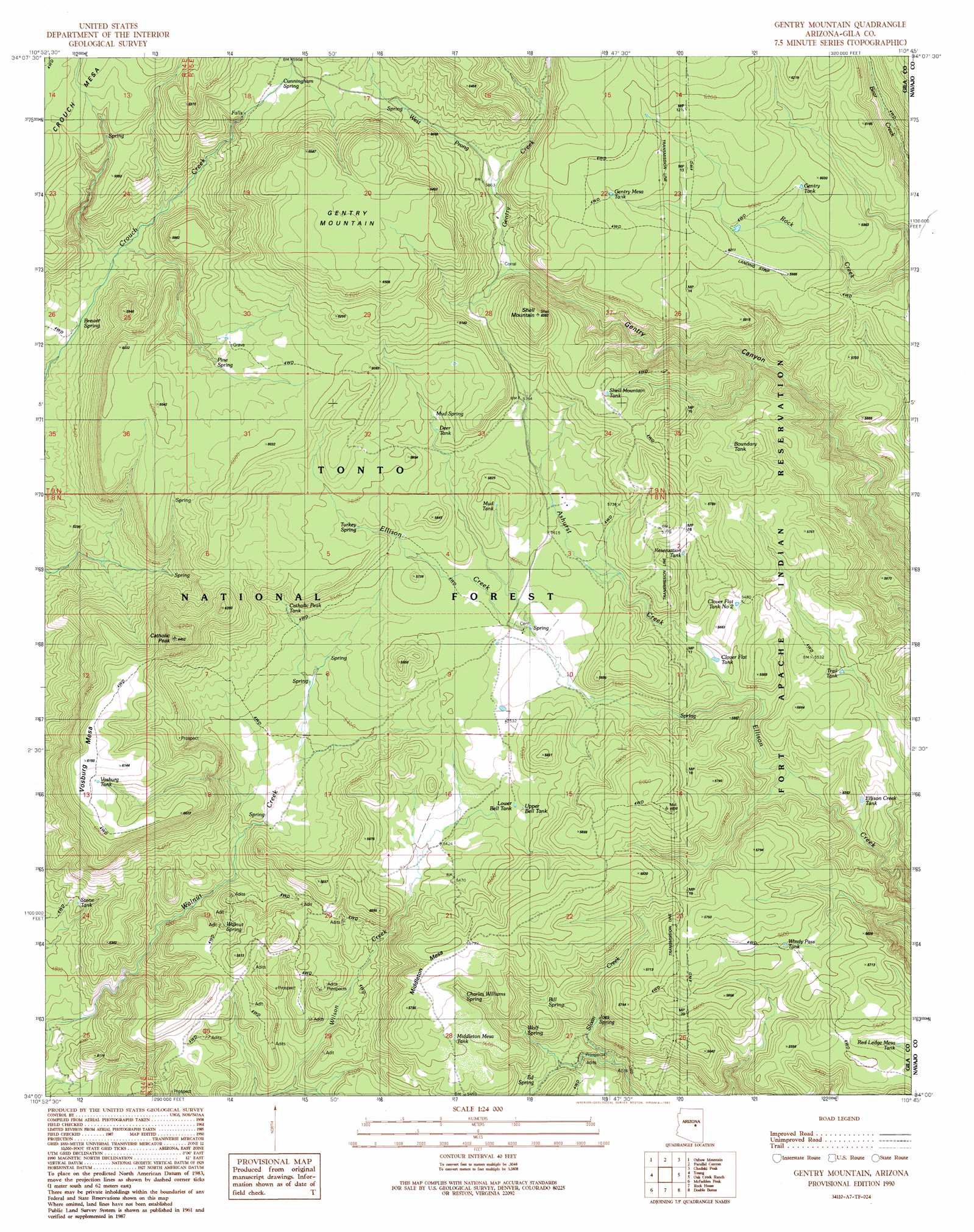
USGS Topo Quad 34110a7 - 1:24,000 scale
| Topo Map Name: | Gentry Mountain |
| USGS Topo Quad ID: | 34110a7 |
| Print Size: | ca. 21 1/4" wide x 27" high |
| Southeast Coordinates: | 34° N latitude / 110.75° W longitude |
| Map Center Coordinates: | 34.0625° N latitude / 110.8125° W longitude |
| U.S. State: | AZ |
| Filename: | o34110a7.jpg |
| Download Map JPG Image: | Gentry Mountain topo map 1:24,000 scale |
| Map Type: | Topographic |
| Topo Series: | 7.5´ |
| Map Scale: | 1:24,000 |
| Source of Map Images: | United States Geological Survey (USGS) |
| Alternate Map Versions: |
Gentry Mountain AZ 1990, updated 1991 Download PDF Buy paper map Gentry Mountain AZ 2004, updated 2006 Download PDF Buy paper map Gentry Mountain AZ 2011 Download PDF Buy paper map Gentry Mountain AZ 2014 Download PDF Buy paper map |
| FStopo: | US Forest Service topo Gentry Mountain is available: Download FStopo PDF Download FStopo TIF |
1:24,000 Topo Quads surrounding Gentry Mountain
Promontory Butte |
Woods Canyon |
O W Point |
Brookbank Point |
Outlaw Draw |
Diamond Butte |
Oxbow Mountain |
Parallel Canyon |
Chediski Peak |
Pepper Canyon |
Buzzard Roost Mesa |
Young |
Gentry Mountain |
Oak Creek Ranch |
Spotted Mountain |
Copper Mountain |
Mcfadden Peak |
Rock House |
Double Buttes |
Blue House Mountain |
Armer Mountain |
Aztec Peak |
Sombrero Peak |
Picacho Colorado |
Mule Hoof Bend |
> Back to 34110a1 at 1:100,000 scale
> Back to 34110a1 at 1:250,000 scale
> Back to U.S. Topo Maps home
Gentry Mountain topo map: Gazetteer
Gentry Mountain: Reservoirs
Allen Tank elevation 1715m 5626′Boundary Tank elevation 1792m 5879′
Catholic Peak Tank elevation 1696m 5564′
Clover Flat Tank elevation 1647m 5403′
Clover Flat Tank Number 2 elevation 1676m 5498′
Deer Tank elevation 1754m 5754′
Ellison Creek Tank elevation 1571m 5154′
Gentry Mesa Tank elevation 1866m 6122′
Gentry Tank elevation 1821m 5974′
Gentry Tank elevation 1950m 6397′
Lower Bell Tank elevation 1683m 5521′
Maxwell Tank elevation 1600m 5249′
Middleton Mesa Tank elevation 1709m 5606′
Mud Tank elevation 1719m 5639′
Red Ledge Mesa Tank elevation 1665m 5462′
Reservation Tank elevation 1700m 5577′
Shell Mountain Tank elevation 1827m 5994′
Stone Tank elevation 1535m 5036′
Trail Tank elevation 1645m 5396′
Upper Bell Tank elevation 1695m 5561′
Vosburg Tank elevation 1843m 6046′
Whiskey Tank elevation 1703m 5587′
Windy Pass Tank elevation 1695m 5561′
Gentry Mountain: Springs
Bill Spring elevation 1692m 5551′Brewer Spring elevation 1597m 5239′
Charles Williams Spring elevation 1663m 5456′
Cunningham Spring elevation 1809m 5935′
Ed Spring elevation 1604m 5262′
Gentry Canyon Spring elevation 1675m 5495′
Joes Spring elevation 1594m 5229′
Mud Spring elevation 1756m 5761′
Pine Spring elevation 1755m 5757′
Pine Spring elevation 1736m 5695′
Turkey Spring elevation 1745m 5725′
Walnut Spring elevation 1544m 5065′
Wolf Spring elevation 1659m 5442′
Gentry Mountain: Streams
Ashurst Creek elevation 1630m 5347′Gentry Creek elevation 1751m 5744′
West Prong Gentry Creek elevation 1781m 5843′
Gentry Mountain: Summits
Catholic Peak elevation 1957m 6420′Gentry Mountain elevation 2001m 6564′
Middleton Mesa elevation 1765m 5790′
Shell Mountain elevation 1943m 6374′
Vosburg Mesa elevation 1865m 6118′
Gentry Mountain digital topo map on disk
Buy this Gentry Mountain topo map showing relief, roads, GPS coordinates and other geographical features, as a high-resolution digital map file on DVD: