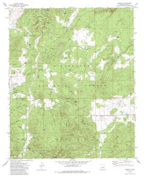
Pinedale Topo Map Arizona
To zoom in, hover over the map of Pinedale
USGS Topo Quad 34110c2 - 1:24,000 scale
| Topo Map Name: | Pinedale |
| USGS Topo Quad ID: | 34110c2 |
| Print Size: | ca. 21 1/4" wide x 27" high |
| Southeast Coordinates: | 34.25° N latitude / 110.125° W longitude |
| Map Center Coordinates: | 34.3125° N latitude / 110.1875° W longitude |
| U.S. State: | AZ |
| Filename: | o34110c2.jpg |
| Download Map JPG Image: | Pinedale topo map 1:24,000 scale |
| Map Type: | Topographic |
| Topo Series: | 7.5´ |
| Map Scale: | 1:24,000 |
| Source of Map Images: | United States Geological Survey (USGS) |
| Alternate Map Versions: |
Pinedale AZ 1970, updated 1973 Download PDF Buy paper map Pinedale AZ 1970, updated 1985 Download PDF Buy paper map Pinedale AZ 1998, updated 2000 Download PDF Buy paper map Pinedale AZ 2011 Download PDF Buy paper map Pinedale AZ 2014 Download PDF Buy paper map |
| FStopo: | US Forest Service topo Pinedale is available: Download FStopo PDF Download FStopo TIF |
1:24,000 Topo Quads surrounding Pinedale
> Back to 34110a1 at 1:100,000 scale
> Back to 34110a1 at 1:250,000 scale
> Back to U.S. Topo Maps home
Pinedale topo map: Gazetteer
Pinedale: Arroyos
Mortensen Wash elevation 1916m 6286′Pinedale: Lakes
Turkey Lake elevation 1860m 6102′Pinedale: Populated Places
Burton elevation 1862m 6108′Linden elevation 1918m 6292′
Pinedale: Post Offices
Pinedale Post Office elevation 1970m 6463′Pinedale: Reservoirs
Bagley Tank elevation 1897m 6223′Bear Tank elevation 2028m 6653′
Bluegrass Tank elevation 1903m 6243′
Brittenham Tank elevation 1927m 6322′
Capps Tank elevation 1930m 6332′
Carlisle Tank elevation 1891m 6204′
Colbath Tank elevation 2011m 6597′
Colbath Wash Tank elevation 2026m 6646′
Community Tank elevation 1927m 6322′
Draw Tank elevation 1884m 6181′
Germ Tank elevation 2006m 6581′
Halfway Tank elevation 1912m 6272′
Henrys Tank elevation 1944m 6377′
Hunt Tank elevation 1915m 6282′
Ironwood Tank elevation 1865m 6118′
Juniper Tank elevation 2048m 6719′
Little VD Tank elevation 1951m 6400′
Lons Tank elevation 1976m 6482′
Lost Tank elevation 1971m 6466′
Louis Tank elevation 1946m 6384′
Malone Tank elevation 1891m 6204′
Mudhole Tank elevation 1940m 6364′
Owens Tank elevation 1920m 6299′
Pasture Tank elevation 1958m 6423′
Paticho Lake elevation 1905m 6250′
Perkins Tank elevation 1926m 6318′
Petersen Tank elevation 1911m 6269′
Peterson Rank Tank elevation 1990m 6528′
Peterson Tank elevation 2011m 6597′
Pine Tank elevation 1935m 6348′
Polson Tank elevation 1977m 6486′
Pothole Tank elevation 1943m 6374′
Railroad Tank elevation 1903m 6243′
Ridge Tank elevation 1910m 6266′
Road Tank elevation 1999m 6558′
Ruddle Tank elevation 1943m 6374′
Sand Tank elevation 1927m 6322′
Section Thirty Tank elevation 1976m 6482′
Silt Tank elevation 1914m 6279′
Smith Tank elevation 1959m 6427′
Thistle Tank elevation 1851m 6072′
Town Tank elevation 1950m 6397′
Turkey Lake Tank elevation 1860m 6102′
Turkey Tank elevation 1955m 6414′
Upper Ironwood Tank elevation 1866m 6122′
VD Tank elevation 1952m 6404′
West Tank elevation 1922m 6305′
Whiting Tank elevation 1979m 6492′
Windmill Tank elevation 1937m 6354′
Pinedale: Ridges
Joe Tank Ridge elevation 2001m 6564′Juniper Ridge elevation 2076m 6811′
Pinedale: Springs
Pinedale Spring elevation 1952m 6404′Pinedale: Streams
Colbath Wash elevation 1918m 6292′Pinedale Wash elevation 1925m 6315′
Pinedale: Summits
Juniper Point elevation 2046m 6712′Pinedale: Valleys
Bear Canyon elevation 1988m 6522′Danish Hollow elevation 1946m 6384′
Lewis Canyon elevation 1958m 6423′
Lons Canyon elevation 1979m 6492′
Main Canyon elevation 1974m 6476′
Thomas Draw elevation 1909m 6263′
Water Canyon elevation 1994m 6541′
Pinedale: Wells
Thistle Well elevation 1861m 6105′Pinedale digital topo map on disk
Buy this Pinedale topo map showing relief, roads, GPS coordinates and other geographical features, as a high-resolution digital map file on DVD:


