Aripine Topo Map Arizona
To zoom in, hover over the map of Aripine
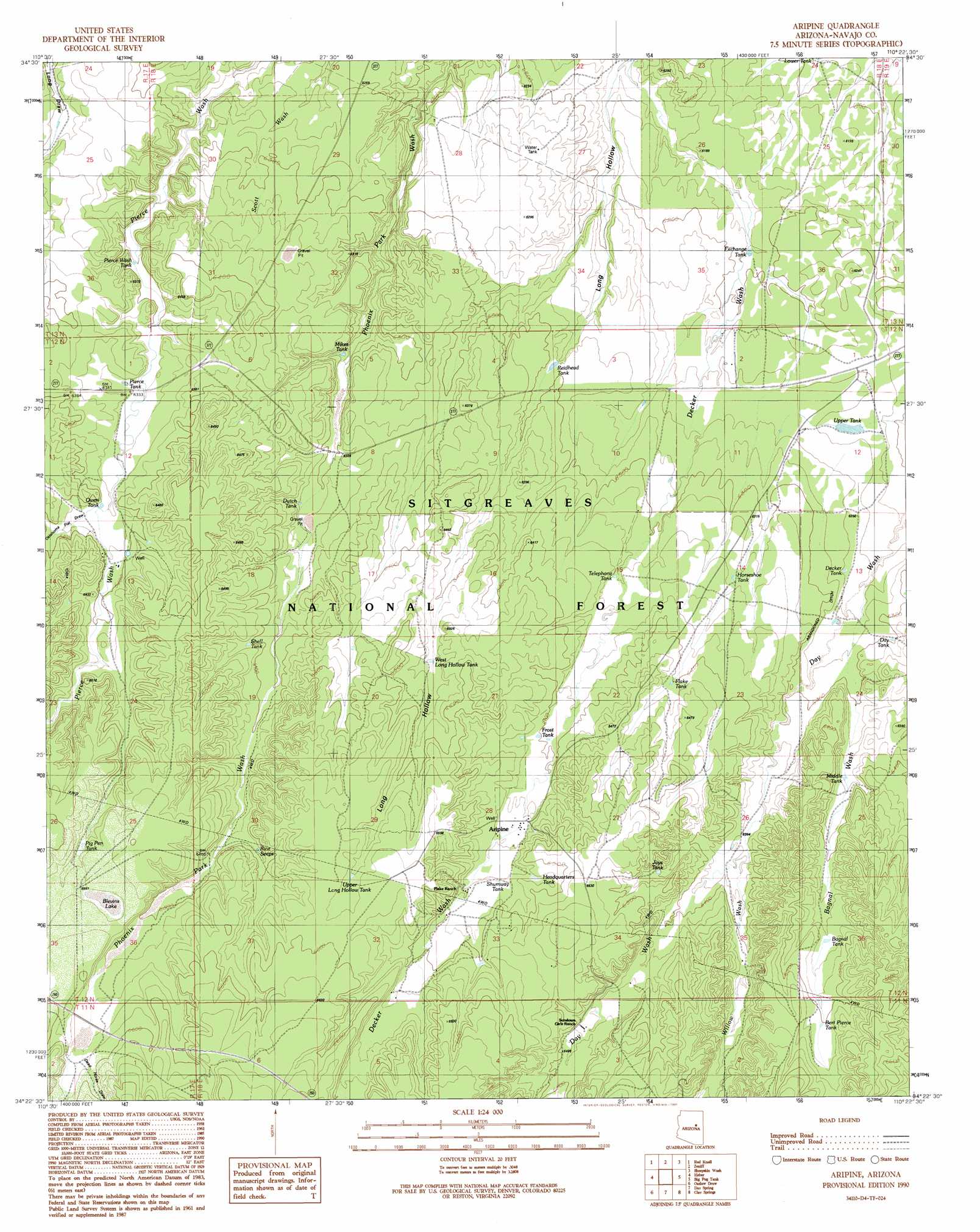
USGS Topo Quad 34110d4 - 1:24,000 scale
| Topo Map Name: | Aripine |
| USGS Topo Quad ID: | 34110d4 |
| Print Size: | ca. 21 1/4" wide x 27" high |
| Southeast Coordinates: | 34.375° N latitude / 110.375° W longitude |
| Map Center Coordinates: | 34.4375° N latitude / 110.4375° W longitude |
| U.S. State: | AZ |
| Filename: | o34110d4.jpg |
| Download Map JPG Image: | Aripine topo map 1:24,000 scale |
| Map Type: | Topographic |
| Topo Series: | 7.5´ |
| Map Scale: | 1:24,000 |
| Source of Map Images: | United States Geological Survey (USGS) |
| Alternate Map Versions: |
Aripine AZ 1990, updated 1991 Download PDF Buy paper map Aripine AZ 1998, updated 2000 Download PDF Buy paper map Aripine AZ 2011 Download PDF Buy paper map Aripine AZ 2014 Download PDF Buy paper map |
| FStopo: | US Forest Service topo Aripine is available: Download FStopo PDF Download FStopo TIF |
1:24,000 Topo Quads surrounding Aripine
Potato Wash North |
Potato Wash Ne |
Dry Lake Nw |
Dry Lake Ne |
Flattop Hill |
Potato Wash South |
Red Knoll |
Zeniff |
Sheepskin Wash |
Second Knolls |
Hanks Draw |
Heber |
Aripine |
Big Pug Tank |
Cactus Flat |
Brookbank Point |
Outlaw Draw |
Day Spring |
Clay Springs |
Pinedale |
Chediski Peak |
Pepper Canyon |
Bear Ridge |
Limestone Canyon North |
Red Top Mountain |
> Back to 34110a1 at 1:100,000 scale
> Back to 34110a1 at 1:250,000 scale
> Back to U.S. Topo Maps home
Aripine topo map: Gazetteer
Aripine: Lakes
Blevins Lake elevation 2000m 6561′Aripine: Populated Places
Aripine elevation 1959m 6427′Aripine: Reservoirs
Bagnal Tank elevation 1968m 6456′Bert Pierre Tank elevation 1984m 6509′
Day Tank elevation 1934m 6345′
Decker Tank elevation 1909m 6263′
Dutchs Tank elevation 1927m 6322′
Exchange Tank elevation 1885m 6184′
Flake Tank elevation 1951m 6400′
Frost Tank elevation 1956m 6417′
Headquarters Tank elevation 1964m 6443′
Horseshoe Tank elevation 1933m 6341′
Jays Tank elevation 1966m 6450′
Lower Tank elevation 1854m 6082′
Middle Tank elevation 1938m 6358′
Mikes Tank elevation 1913m 6276′
Owens Tank elevation 1944m 6377′
Pierce Tank elevation 1927m 6322′
Pierce Wash Tank elevation 1917m 6289′
Pig Pen Tank elevation 1992m 6535′
Reidhead Tank elevation 1921m 6302′
Shell Tank elevation 1954m 6410′
Shumway Tank elevation 1976m 6482′
Telephone Tank elevation 1932m 6338′
Upper Long Hollow Tank elevation 2001m 6564′
Upper Tank elevation 1902m 6240′
West Long Hollow Tank elevation 1964m 6443′
Aripine: Springs
Rice Seeps elevation 1975m 6479′Aripine: Streams
Bagnal Wash elevation 1909m 6263′Willow Wash elevation 1939m 6361′
Aripine: Valleys
Dead Horse Draw elevation 2007m 6584′Long Hollow elevation 1870m 6135′
Oklahoma Flat Draw elevation 1942m 6371′
Aripine: Wells
Park Well elevation 1908m 6259′Aripine digital topo map on disk
Buy this Aripine topo map showing relief, roads, GPS coordinates and other geographical features, as a high-resolution digital map file on DVD: