Table Mountain Topo Map Arizona
To zoom in, hover over the map of Table Mountain
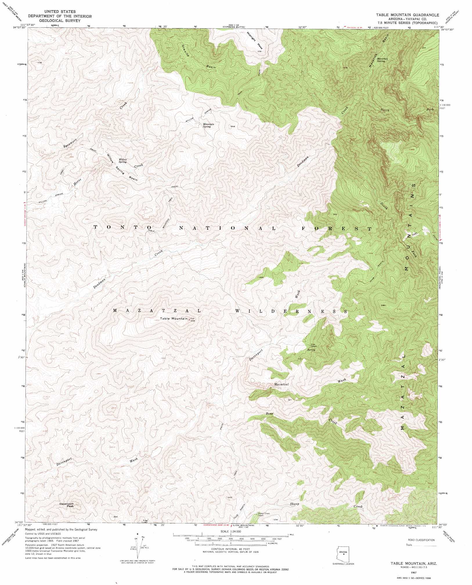
USGS Topo Quad 34111a5 - 1:24,000 scale
| Topo Map Name: | Table Mountain |
| USGS Topo Quad ID: | 34111a5 |
| Print Size: | ca. 21 1/4" wide x 27" high |
| Southeast Coordinates: | 34° N latitude / 111.5° W longitude |
| Map Center Coordinates: | 34.0625° N latitude / 111.5625° W longitude |
| U.S. State: | AZ |
| Filename: | o34111a5.jpg |
| Download Map JPG Image: | Table Mountain topo map 1:24,000 scale |
| Map Type: | Topographic |
| Topo Series: | 7.5´ |
| Map Scale: | 1:24,000 |
| Source of Map Images: | United States Geological Survey (USGS) |
| Alternate Map Versions: |
Table Mountain AZ 1967, updated 1968 Download PDF Buy paper map Table Mountain AZ 1967, updated 1976 Download PDF Buy paper map Table Mountain AZ 2004, updated 2006 Download PDF Buy paper map Table Mountain AZ 2011 Download PDF Buy paper map Table Mountain AZ 2014 Download PDF Buy paper map |
| FStopo: | US Forest Service topo Table Mountain is available: Download FStopo PDF Download FStopo TIF |
1:24,000 Topo Quads surrounding Table Mountain
Tule Mesa |
Verde Hot Springs |
Cane Springs Mountain |
Buckhead Mesa |
Payson North |
Bloody Basin |
Wet Bottom Mesa |
Cypress Butte |
North Peak |
Payson South |
Rover Peak |
Chalk Mountain |
Table Mountain |
Mazatzal Peak |
Gisela |
Humboldt Mountain |
Horseshoe Dam |
Lion Mountain |
Reno Pass |
Kayler Butte |
Wildcat Hill |
Bartlett Dam |
Maverick Mountain |
Boulder Mountain |
Tonto Basin |
> Back to 34111a1 at 1:100,000 scale
> Back to 34110a1 at 1:250,000 scale
> Back to U.S. Topo Maps home
Table Mountain topo map: Gazetteer
Table Mountain: Basins
Granite Basin elevation 1392m 4566′Maverick Basin elevation 1451m 4760′
Willow Spring Basin elevation 1147m 3763′
Table Mountain: Springs
Divide Spring elevation 1511m 4957′Dog Spring elevation 1060m 3477′
Lost Spring elevation 1492m 4895′
Maverick Spring elevation 1366m 4481′
Mesquite Spring elevation 1207m 3959′
Midway Spring elevation 931m 3054′
Mountain Spring elevation 1476m 4842′
Red Rock Spring elevation 1320m 4330′
Rock Spring elevation 1079m 3540′
Round Spring elevation 1186m 3891′
Wash Spring elevation 850m 2788′
Willow Spring elevation 1108m 3635′
Table Mountain: Streams
Bear Creek elevation 875m 2870′Mazatzal Wash elevation 939m 3080′
North Fork Deadman Creek elevation 1233m 4045′
South Fork Deadman Creek elevation 1118m 3667′
Table Mountain: Summits
Davenport Peak elevation 1209m 3966′Table Mountain elevation 1642m 5387′
Table Mountain: Trails
Club Ranch Trail elevation 1198m 3930′Table Mountain Trail elevation 1176m 3858′
Willow Spring Trail elevation 1636m 5367′
Table Mountain digital topo map on disk
Buy this Table Mountain topo map showing relief, roads, GPS coordinates and other geographical features, as a high-resolution digital map file on DVD: