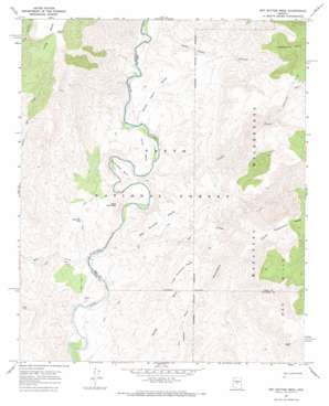
Wet Bottom Mesa Topo Map Arizona
To zoom in, hover over the map of Wet Bottom Mesa
USGS Topo Quad 34111b6 - 1:24,000 scale
| Topo Map Name: | Wet Bottom Mesa |
| USGS Topo Quad ID: | 34111b6 |
| Print Size: | ca. 21 1/4" wide x 27" high |
| Southeast Coordinates: | 34.125° N latitude / 111.625° W longitude |
| Map Center Coordinates: | 34.1875° N latitude / 111.6875° W longitude |
| U.S. State: | AZ |
| Filename: | o34111b6.jpg |
| Download Map JPG Image: | Wet Bottom Mesa topo map 1:24,000 scale |
| Map Type: | Topographic |
| Topo Series: | 7.5´ |
| Map Scale: | 1:24,000 |
| Source of Map Images: | United States Geological Survey (USGS) |
| Alternate Map Versions: |
Wet Bottom Mesa AZ 1967, updated 1968 Download PDF Buy paper map Wet Bottom Mesa AZ 2004, updated 2007 Download PDF Buy paper map Wet Bottom Mesa AZ 2011 Download PDF Buy paper map Wet Bottom Mesa AZ 2014 Download PDF Buy paper map |
| FStopo: | US Forest Service topo Wet Bottom Mesa is available: Download FStopo PDF Download FStopo TIF |
1:24,000 Topo Quads surrounding Wet Bottom Mesa
> Back to 34111a1 at 1:100,000 scale
> Back to 34110a1 at 1:250,000 scale
> Back to U.S. Topo Maps home
Wet Bottom Mesa topo map: Gazetteer
Wet Bottom Mesa: Bends
Mule Shoe Bend elevation 747m 2450′Wet Bottom Mesa: Rapids
Red Creek Rapids elevation 666m 2185′Wet Bottom Mesa: Reservoirs
Peach Tank elevation 1292m 4238′Table Mountain Tank elevation 748m 2454′
Wet Bottom Mesa: Ridges
Razorback elevation 1271m 4169′Wet Bottom Mesa: Springs
Marie Spring elevation 951m 3120′Petes Spring elevation 857m 2811′
Rock Tank Spring elevation 898m 2946′
Wet Bottom Mesa: Streams
Canyon Creek elevation 697m 2286′Clover Creek elevation 1268m 4160′
Cottonwood Creek elevation 1116m 3661′
Goat Camp Creek elevation 728m 2388′
Wet Bottom Creek elevation 664m 2178′
Wet Bottom Mesa: Summits
Canoe Mesa elevation 803m 2634′Lower Racetrack Mesa elevation 1050m 3444′
Petes Cabin Mesa elevation 783m 2568′
Red Hills elevation 1236m 4055′
Table Mountain elevation 880m 2887′
Upper Racetrack Mesa elevation 1479m 4852′
Wet Bottom Mesa elevation 969m 3179′
Wet Bottom Mesa: Valleys
Goat Camp Canyon elevation 743m 2437′Wet Bottom Mesa digital topo map on disk
Buy this Wet Bottom Mesa topo map showing relief, roads, GPS coordinates and other geographical features, as a high-resolution digital map file on DVD:


