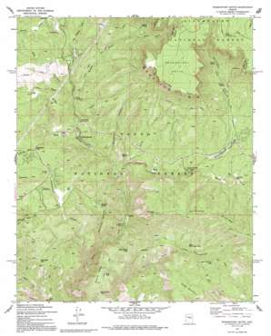
Promontory Butte Topo Map Arizona
To zoom in, hover over the map of Promontory Butte
USGS Topo Quad 34111c1 - 1:24,000 scale
| Topo Map Name: | Promontory Butte |
| USGS Topo Quad ID: | 34111c1 |
| Print Size: | ca. 21 1/4" wide x 27" high |
| Southeast Coordinates: | 34.25° N latitude / 111° W longitude |
| Map Center Coordinates: | 34.3125° N latitude / 111.0625° W longitude |
| U.S. State: | AZ |
| Filename: | o34111c1.jpg |
| Download Map JPG Image: | Promontory Butte topo map 1:24,000 scale |
| Map Type: | Topographic |
| Topo Series: | 7.5´ |
| Map Scale: | 1:24,000 |
| Source of Map Images: | United States Geological Survey (USGS) |
| Alternate Map Versions: |
Promontory Butte AZ 1973, updated 1975 Download PDF Buy paper map Promontory Butte AZ 1973, updated 1986 Download PDF Buy paper map Promontory Butte AZ 1973, updated 1991 Download PDF Buy paper map Promontory Butte AZ 1973, updated 1991 Download PDF Buy paper map Promontory Butte AZ 1998, updated 2001 Download PDF Buy paper map Promontory Butte AZ 2011 Download PDF Buy paper map Promontory Butte AZ 2014 Download PDF Buy paper map |
| FStopo: | US Forest Service topo Promontory Butte is available: Download FStopo PDF Download FStopo TIF |
1:24,000 Topo Quads surrounding Promontory Butte
> Back to 34111a1 at 1:100,000 scale
> Back to 34110a1 at 1:250,000 scale
> Back to U.S. Topo Maps home
Promontory Butte topo map: Gazetteer
Promontory Butte: Cliffs
Promontory Butte elevation 2391m 7844′Promontory Butte: Flats
Bear Flat elevation 1511m 4957′Promontory Butte: Populated Places
Bear Flat elevation 1513m 4963′Christopher Creek elevation 1768m 5800′
Christopher Creek elevation 1791m 5875′
Hunter Creek Ranch elevation 1786m 5859′
Kohls Ranch elevation 1633m 5357′
Mountain Meadow elevation 1817m 5961′
Mountain Meadows elevation 1829m 6000′
See Canyon Summer Homes elevation 1831m 6007′
Thompson Draw Summer Homes Unit One elevation 1781m 5843′
Thompson Draw Summer Homes Unit Two elevation 1731m 5679′
Tonto Estate elevation 1755m 5757′
Promontory Butte: Post Offices
Kohls Ranch Post Office (historical) elevation 1633m 5357′Promontory Butte: Reservoirs
Bear Flat Trail Tank elevation 1827m 5994′Boy Tank elevation 1688m 5538′
Bull Tank elevation 1633m 5357′
Cabin Tank elevation 1636m 5367′
Christopher Tank elevation 1997m 6551′
Horse Pasture Tank elevation 1666m 5465′
King Ridge Tank elevation 1738m 5702′
King Tank Number Three elevation 1587m 5206′
Mescal Ridge Tank Number One elevation 1649m 5410′
Mescal Ridge Tank Number Two elevation 1716m 5629′
Schoolhouse Tank elevation 1731m 5679′
Scout Tank elevation 1682m 5518′
Twenty Tank elevation 1759m 5770′
Upper Bull Canyon Tank elevation 1748m 5734′
Promontory Butte: Ridges
Christopher Mountain elevation 2042m 6699′King Ridge elevation 1757m 5764′
Mescal Ridge elevation 1716m 5629′
Turkey Ridge elevation 1806m 5925′
Promontory Butte: Springs
Bearhide Spring elevation 1630m 5347′Bootleg Spring elevation 1633m 5357′
Herman Spring elevation 1927m 6322′
Horton Spring elevation 2054m 6738′
Nappa Spring elevation 2021m 6630′
See Spring elevation 2024m 6640′
Promontory Butte: Streams
Christopher Creek elevation 1561m 5121′Dick Williams Creek elevation 1755m 5757′
East Fork Horton Creek elevation 1924m 6312′
Horton Creek elevation 1665m 5462′
Hunter Creek elevation 1745m 5725′
Spring Creek elevation 1586m 5203′
Promontory Butte: Summits
Horse Mountain elevation 1951m 6400′Kushs Mountain elevation 1778m 5833′
Promontory Butte: Trails
Bear Flat Pleasant Valley Trail elevation 1719m 5639′Derrick Trail elevation 1810m 5938′
Horton Creek Trail elevation 1772m 5813′
Promontory Butte: Valleys
Bearhide Canyon elevation 1472m 4829′Big Canyon elevation 1658m 5439′
Box Canyon elevation 1572m 5157′
Cabin Draw elevation 1681m 5515′
Doubtful Canyon elevation 1584m 5196′
See Canyon elevation 1729m 5672′
Thompson Draw elevation 1412m 4632′
Promontory Butte digital topo map on disk
Buy this Promontory Butte topo map showing relief, roads, GPS coordinates and other geographical features, as a high-resolution digital map file on DVD:


