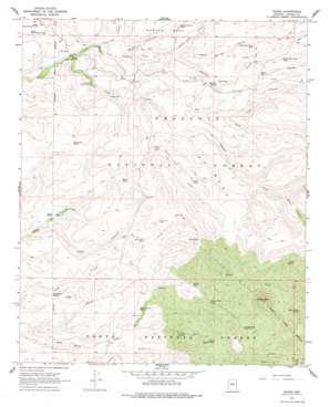
Dugas Topo Map Arizona
To zoom in, hover over the map of Dugas
USGS Topo Quad 34111c8 - 1:24,000 scale
| Topo Map Name: | Dugas |
| USGS Topo Quad ID: | 34111c8 |
| Print Size: | ca. 21 1/4" wide x 27" high |
| Southeast Coordinates: | 34.25° N latitude / 111.875° W longitude |
| Map Center Coordinates: | 34.3125° N latitude / 111.9375° W longitude |
| U.S. State: | AZ |
| Filename: | o34111c8.jpg |
| Download Map JPG Image: | Dugas topo map 1:24,000 scale |
| Map Type: | Topographic |
| Topo Series: | 7.5´ |
| Map Scale: | 1:24,000 |
| Source of Map Images: | United States Geological Survey (USGS) |
| Alternate Map Versions: |
Dugas AZ 1967, updated 1968 Download PDF Buy paper map Dugas AZ 1967, updated 1978 Download PDF Buy paper map Dugas AZ 1967, updated 1978 Download PDF Buy paper map Dugas AZ 2012 Download PDF Buy paper map Dugas AZ 2014 Download PDF Buy paper map |
| FStopo: | US Forest Service topo Dugas is available: Download FStopo PDF Download FStopo TIF |
1:24,000 Topo Quads surrounding Dugas
> Back to 34111a1 at 1:100,000 scale
> Back to 34110a1 at 1:250,000 scale
> Back to U.S. Topo Maps home
Dugas topo map: Gazetteer
Dugas: Dams
Blue Rock Dam elevation 1504m 4934′Dugas: Populated Places
Dugas elevation 1200m 3937′Dugas: Reservoirs
Blue Rock Tank elevation 1504m 4934′Burmister Tank elevation 1303m 4274′
Granite Mountain Tank elevation 1336m 4383′
Granite Mountain Tank Number Two elevation 1439m 4721′
Holdin Pasture Tank elevation 1332m 4370′
Jacks Tank elevation 1473m 4832′
Long Gulch Tank elevation 1293m 4242′
Lower Dry Pasture Tank elevation 1231m 4038′
McRae Tank elevation 1300m 4265′
Mesa Tank elevation 1386m 4547′
North Bishop Tank elevation 1424m 4671′
Pot Hole Tank elevation 1531m 5022′
Rock Spring Draw Tank elevation 1424m 4671′
Silver Creek Tank elevation 1236m 4055′
South Tank elevation 1244m 4081′
Upper Dry Pasture Tank elevation 1247m 4091′
Willow Spring Wash Tank elevation 1465m 4806′
Dugas: Springs
Cabin Spring elevation 1527m 5009′Canyon Water elevation 1292m 4238′
Dry Creek Spring Number One elevation 1265m 4150′
Dry Creek Spring Number Two elevation 1348m 4422′
Dry Creek Water elevation 1438m 4717′
Graveyard Spring elevation 1296m 4251′
Hidden Spring elevation 1572m 5157′
Highball Spring elevation 1364m 4475′
Indian Creek Trail Spring elevation 1172m 3845′
Long Gulch Spring elevation 1183m 3881′
Lower Water elevation 1172m 3845′
Middle Water elevation 1255m 4117′
Mud Spring elevation 1441m 4727′
Reno Spring elevation 1292m 4238′
Rock Seep elevation 1375m 4511′
Rock Spring elevation 1466m 4809′
Silver Creek Spring elevation 1510m 4954′
Tule Creek Seep Number One elevation 1394m 4573′
Tule Number Two Water elevation 1481m 4858′
Twenty Two Mesa Seep elevation 1366m 4481′
Upper Water elevation 1301m 4268′
Willow Spring elevation 1439m 4721′
Dugas: Streams
Dry Creek elevation 1254m 4114′Little Sycamore Creek elevation 1192m 3910′
South Prong Sycamore Creek elevation 1398m 4586′
Dugas: Summits
22 Mesa elevation 1597m 5239′22 Mesa elevation 1595m 5232′
Granite Peak elevation 1732m 5682′
Marlow Mesa elevation 1392m 4566′
Rice Peak elevation 1587m 5206′
Dugas: Valleys
Chalk Tank Canyon elevation 1291m 4235′Clays Well Canyon elevation 1228m 4028′
Cow Canyon elevation 1158m 3799′
Reno Canyon elevation 1240m 4068′
Rock Spring Draw elevation 1292m 4238′
Tule Canyon elevation 1365m 4478′
Willow Spring Gulch elevation 1291m 4235′
Dugas: Wells
Grapevine Well elevation 1339m 4393′Dugas digital topo map on disk
Buy this Dugas topo map showing relief, roads, GPS coordinates and other geographical features, as a high-resolution digital map file on DVD:


