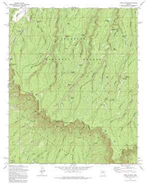
Dane Canyon Topo Map Arizona
To zoom in, hover over the map of Dane Canyon
USGS Topo Quad 34111d2 - 1:24,000 scale
| Topo Map Name: | Dane Canyon |
| USGS Topo Quad ID: | 34111d2 |
| Print Size: | ca. 21 1/4" wide x 27" high |
| Southeast Coordinates: | 34.375° N latitude / 111.125° W longitude |
| Map Center Coordinates: | 34.4375° N latitude / 111.1875° W longitude |
| U.S. State: | AZ |
| Filename: | o34111d2.jpg |
| Download Map JPG Image: | Dane Canyon topo map 1:24,000 scale |
| Map Type: | Topographic |
| Topo Series: | 7.5´ |
| Map Scale: | 1:24,000 |
| Source of Map Images: | United States Geological Survey (USGS) |
| Alternate Map Versions: |
Dane Canyon AZ 1972, updated 1974 Download PDF Buy paper map Dane Canyon AZ 1972, updated 1982 Download PDF Buy paper map Dane Canyon AZ 1972, updated 1982 Download PDF Buy paper map Dane Canyon AZ 2004, updated 2006 Download PDF Buy paper map Dane Canyon AZ 2011 Download PDF Buy paper map Dane Canyon AZ 2014 Download PDF Buy paper map |
| FStopo: | US Forest Service topo Dane Canyon is available: Download FStopo PDF Download FStopo TIF |
1:24,000 Topo Quads surrounding Dane Canyon
> Back to 34111a1 at 1:100,000 scale
> Back to 34110a1 at 1:250,000 scale
> Back to U.S. Topo Maps home
Dane Canyon topo map: Gazetteer
Dane Canyon: Cliffs
Burnt Point elevation 2288m 7506′Dane Canyon: Lakes
Dude Lake elevation 2329m 7641′Lost Lake elevation 2402m 7880′
Myrtle Lake elevation 2391m 7844′
Dane Canyon: Populated Places
Bonita Creek Estates elevation 1803m 5915′Dane Canyon: Reservoirs
Backhoe Tank Number Six elevation 2230m 7316′Nonsuitable Tank elevation 2315m 7595′
Yeager Tank elevation 2332m 7650′
Dane Canyon: Ridges
Buck Springs Ridge elevation 2234m 7329′Dane Ridge elevation 2209m 7247′
Dick Hart Ridge elevation 2289m 7509′
Fred Haught Ridge elevation 2233m 7326′
Hospital Ridge elevation 2323m 7621′
McClintock Ridge elevation 2273m 7457′
Dane Canyon: Springs
Aspen Spring elevation 2195m 7201′Barbershop Spring elevation 2292m 7519′
Coyote Spring elevation 2281m 7483′
Crackerbox Spring elevation 2164m 7099′
Dane Spring elevation 2246m 7368′
Drift Fence Spring elevation 2170m 7119′
Floyd Spring elevation 2232m 7322′
Fred Haught Spring elevation 2132m 6994′
Lower Buck Spring elevation 2284m 7493′
McClintock Spring elevation 2208m 7244′
McFarland Spring elevation 2233m 7326′
Merritt Spring elevation 2273m 7457′
Middle Leonard Number Four Spring elevation 2365m 7759′
Middle Leonard Number Two Spring elevation 2404m 7887′
Moonshine Spring elevation 2229m 7312′
Pinchot Spring elevation 2179m 7148′
Schneider Spring elevation 2223m 7293′
Turkey Spring elevation 2321m 7614′
Upper Buck Spring elevation 2313m 7588′
West Moonshine Spring elevation 2220m 7283′
Whistling Spring elevation 2295m 7529′
Dane Canyon: Trails
Myrtle Trail elevation 2260m 7414′Dane Canyon: Valleys
Bill McClintock Draw elevation 2205m 7234′Box Canyon elevation 2133m 6998′
East Bear Canyon elevation 2167m 7109′
Fred Haught Canyon elevation 2130m 6988′
Maverick Canyon elevation 2180m 7152′
Merritt Draw elevation 2123m 6965′
Moonshine Draw elevation 2144m 7034′
West Bear Canyon elevation 2182m 7158′
West Moonshine Draw elevation 2195m 7201′
Dane Canyon digital topo map on disk
Buy this Dane Canyon topo map showing relief, roads, GPS coordinates and other geographical features, as a high-resolution digital map file on DVD:


