Leonard Canyon Topo Map Arizona
To zoom in, hover over the map of Leonard Canyon
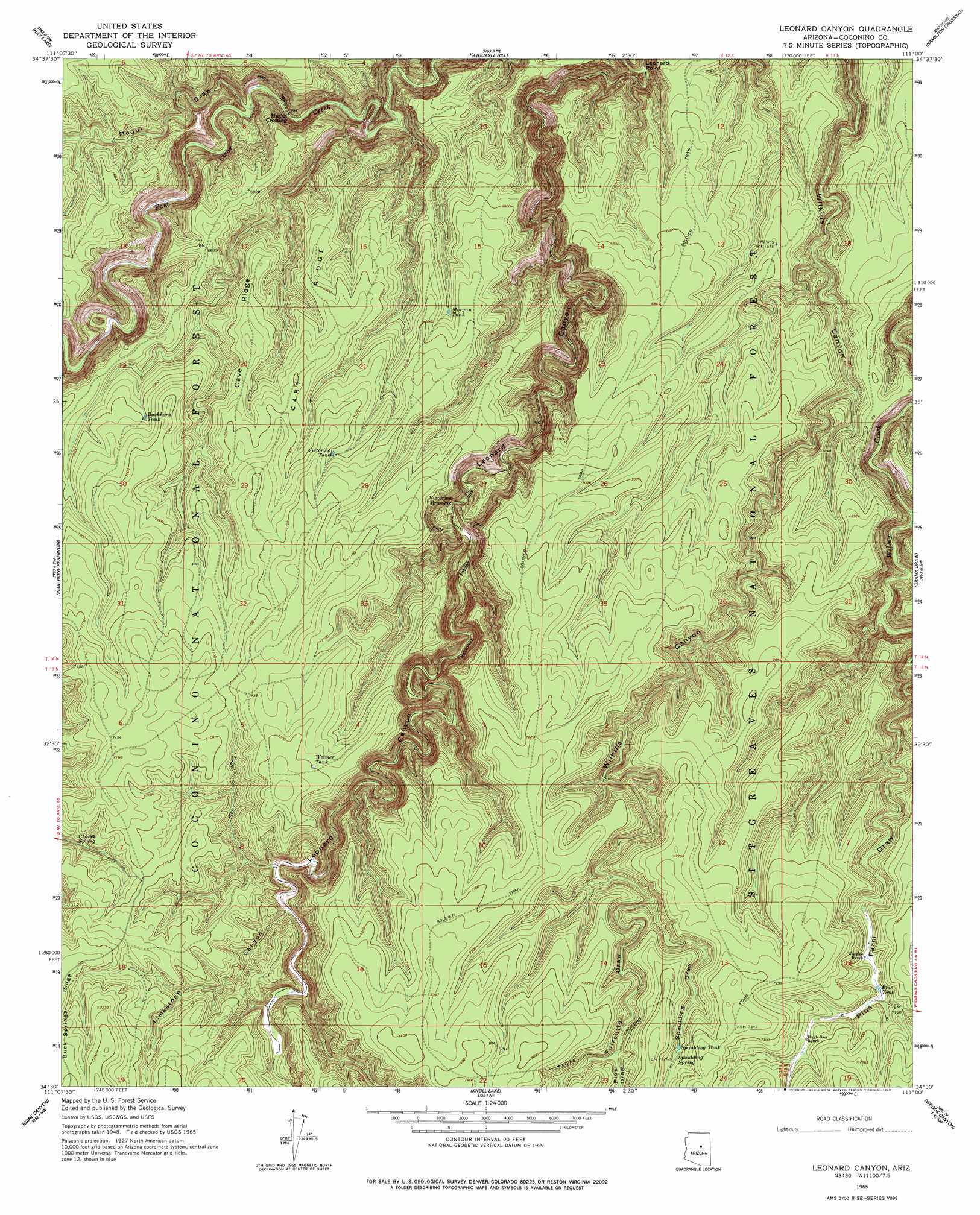
USGS Topo Quad 34111e1 - 1:24,000 scale
| Topo Map Name: | Leonard Canyon |
| USGS Topo Quad ID: | 34111e1 |
| Print Size: | ca. 21 1/4" wide x 27" high |
| Southeast Coordinates: | 34.5° N latitude / 111° W longitude |
| Map Center Coordinates: | 34.5625° N latitude / 111.0625° W longitude |
| U.S. State: | AZ |
| Filename: | o34111e1.jpg |
| Download Map JPG Image: | Leonard Canyon topo map 1:24,000 scale |
| Map Type: | Topographic |
| Topo Series: | 7.5´ |
| Map Scale: | 1:24,000 |
| Source of Map Images: | United States Geological Survey (USGS) |
| Alternate Map Versions: |
Leonard Canyon AZ 1965, updated 1967 Download PDF Buy paper map Leonard Canyon AZ 1965, updated 1978 Download PDF Buy paper map Leonard Canyon AZ 1998, updated 2000 Download PDF Buy paper map Leonard Canyon AZ 2011 Download PDF Buy paper map Leonard Canyon AZ 2014 Download PDF Buy paper map |
| FStopo: | US Forest Service topo Leonard Canyon is available: Download FStopo PDF Download FStopo TIF |
1:24,000 Topo Quads surrounding Leonard Canyon
Jaycox Mountain |
Chavez Mountain West |
Chavez Mountain East |
Sunset Pass |
Pump Ranch Tank |
Turkey Mountain |
Hay Lake |
Quayle Hill |
Hamilton Crossing |
Chevelon Butte |
Long Valley |
Blue Ridge Reservoir |
Leonard Canyon |
Grama Draw |
Chevelon Crossing |
Kehl Ridge |
Dane Canyon |
Knoll Lake |
Porcupine Ridge |
Weimer Point |
Payson North |
Diamond Point |
Promontory Butte |
Woods Canyon |
O W Point |
> Back to 34111e1 at 1:100,000 scale
> Back to 34110a1 at 1:250,000 scale
> Back to U.S. Topo Maps home
Leonard Canyon topo map: Gazetteer
Leonard Canyon: Cliffs
Leonard Point elevation 1906m 6253′Leonard Canyon: Populated Places
Macks Crossing elevation 1907m 6256′Victorine Crossing elevation 2001m 6564′
Leonard Canyon: Reservoirs
Buckhorn Tank elevation 2104m 6902′Elkhorn Tank elevation 2169m 7116′
Fork Tank elevation 2094m 6870′
Kevin Tank elevation 2160m 7086′
Middle Tank elevation 2111m 6925′
Morgan Tank elevation 2074m 6804′
Pius Tank elevation 2159m 7083′
Saltground Tank elevation 2123m 6965′
Second Chance Tank elevation 2139m 7017′
Spaulding Tank elevation 2196m 7204′
Victorine Tank elevation 2132m 6994′
Weimer Tank elevation 2193m 7194′
Wilkins Trick Tank elevation 2067m 6781′
Leonard Canyon: Ridges
Cart Ridge elevation 2118m 6948′Cave Ridge elevation 2116m 6942′
Leonard Canyon: Springs
Chavez Spring elevation 2125m 6971′Limestone Spring elevation 2183m 7162′
Spaulding Spring elevation 2199m 7214′
Leonard Canyon: Streams
East Clear Creek elevation 1893m 6210′Leonard Canyon: Trails
Soldier Trail elevation 2160m 7086′Leonard Canyon: Valleys
Fairchild Draw elevation 2151m 7057′Leonard Canyon elevation 1870m 6135′
Limestone Canyon elevation 2093m 6866′
Moqui Draw elevation 1917m 6289′
Pius Draw elevation 2182m 7158′
Pius Farm Draw elevation 2004m 6574′
Spaulding Draw elevation 2148m 7047′
Leonard Canyon digital topo map on disk
Buy this Leonard Canyon topo map showing relief, roads, GPS coordinates and other geographical features, as a high-resolution digital map file on DVD: